
| Birth | : | 29 Aug 1819 Oldwick, Hunterdon County, New Jersey, USA |
| Death | : | 10 May 1883 Burlingame, Osage County, Kansas, USA |
| Burial | : | Howsham Churchyard, Howsham, Ryedale District, England |
| Coordinate | : | 54.0565520, -0.8755670 |
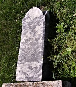
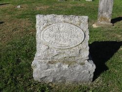
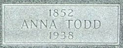
| Description | : | Ann Barbara Gulick was born on 29 August 1819, in Oldwick, Hunterdon, New Jersey, United States, her father, Joachim Gulick, was 34 and her mother, Elizabeth Genther, was 33. She married Henry Todd on 6 August 1842, in Somerset, New Jersey. They were the parents of at 2 sons and 2 daughters. She lived in Superior Township, Osage, Kansas, for about 5 years and Dragoon Township, Osage, Kansas, for about 5 years. She died on 10 May 1883, in Burlingame, Osage, Kansas, at the age of 63, and was buried in Burlingame City Cemetery, Burlingame, Osage, Kansas. |
frequently asked questions (FAQ):
-
Where is Ann Barbara Gulick Todd's memorial?
Ann Barbara Gulick Todd's memorial is located at: Howsham Churchyard, Howsham, Ryedale District, England.
-
When did Ann Barbara Gulick Todd death?
Ann Barbara Gulick Todd death on 10 May 1883 in Burlingame, Osage County, Kansas, USA
-
Where are the coordinates of the Ann Barbara Gulick Todd's memorial?
Latitude: 54.0565520
Longitude: -0.8755670
Family Members:
Spouse
Children
Flowers:


Nearby Cemetories:
1. Howsham Churchyard
Howsham, Ryedale District, England
Coordinate: 54.0565520, -0.8755670
2. St Michael Churchyard
Crambe, Ryedale District, England
Coordinate: 54.0744550, -0.8809390
3. St Peter and St Paul Churchyard
Scrayingham, Ryedale District, England
Coordinate: 54.0342510, -0.8826130
4. St Botolph Churchyard
Bossall, Ryedale District, England
Coordinate: 54.0375570, -0.9047540
5. Kirkham Priory
Kirkham, Ryedale District, England
Coordinate: 54.0826180, -0.8768470
6. St. Mary's Churchyard
Westow, Ryedale District, England
Coordinate: 54.0846190, -0.8406850
7. All Saints Churchyard
Foston, Ryedale District, England
Coordinate: 54.0775719, -0.9331510
8. St John the Evangelist Churchyard
Buttercrambe, Ryedale District, England
Coordinate: 54.0137300, -0.8812900
9. St John the Baptist
Acklam, Ryedale District, England
Coordinate: 54.0451010, -0.8006330
10. St John the Evangelist Churchyard
Welburn (Malton), Ryedale District, England
Coordinate: 54.1008850, -0.8985440
11. Burythorpe Churchyard
Burythorpe, Ryedale District, England
Coordinate: 54.0752951, -0.7955984
12. St Lawrence Churchyard
Flaxton, Ryedale District, England
Coordinate: 54.0508680, -0.9624500
13. St. Margaret's Churchyard
Huttons Ambo, Ryedale District, England
Coordinate: 54.1066490, -0.8490640
14. St. Mary's Churchyard
Sand Hutton, Ryedale District, England
Coordinate: 54.0183800, -0.9410700
15. St Martin Churchyard
Bulmer, Ryedale District, England
Coordinate: 54.0997510, -0.9317700
16. St Andrew Churchyard
Bugthorpe, East Riding of Yorkshire Unitary Authority, England
Coordinate: 54.0108100, -0.8226900
17. Castle Howard Mausoleum
Castle Howard, Ryedale District, England
Coordinate: 54.1173870, -0.8886900
18. St Peter Churchyard
Upper Helmsley, Ryedale District, England
Coordinate: 54.0044650, -0.9409770
19. St Andrew Churchyard
Langton, Ryedale District, England
Coordinate: 54.0934510, -0.7834680
20. St Mary Churchyard
Full Sutton, East Riding of Yorkshire Unitary Authority, England
Coordinate: 53.9897620, -0.8613700
21. All Saints Churchyard
Kirby Underdale, East Riding of Yorkshire Unitary Authority, England
Coordinate: 54.0166200, -0.7677100
22. Coneysthorpe Cemetery
Coneysthorpe, Ryedale District, England
Coordinate: 54.1308750, -0.9042820
23. St Mary Churchyard
Birdsall, Ryedale District, England
Coordinate: 54.0780000, -0.7508000
24. St Helen and the Holy Cross Churchyard
Sheriff Hutton, Ryedale District, England
Coordinate: 54.0882280, -0.9965280