
| Birth | : | 15 Jul 1905 Iowa, USA |
| Death | : | 30 May 1980 Riceville, Mitchell County, Iowa, USA |
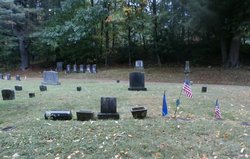
| Burial | : | Nether Stowey Cemetery, Nether Stowey, Sedgemoor District, England |
| Coordinate | : | 51.1498667, -3.1530087 |
| Description | : | ANNA UTESCH July 15, 1905 - May 31, 1980 Anna Augusta Ring was born on July 15, 1905 in Howard County to her parents, August and Minnie (Kleim) Ring. On August 9, 1927 she married Carl Frederick Utesch. They farmed near Perryville, Missouri, for three years. In 1930 they moved to Riceville and farmed for 36 years. In 1974, together with their son Dick, they began the A and D Greenhouse in Riceville. Anna was very active in the St. Peter's Lutheran Church ladies Aid. Mrs. Utesch suffered a stroke on Tuesday, May 27 and was taken to the Mitchell... Read More |
frequently asked questions (FAQ):
-
Where is Anna Augusta Ring Utesch's memorial?
Anna Augusta Ring Utesch's memorial is located at: Nether Stowey Cemetery, Nether Stowey, Sedgemoor District, England.
-
When did Anna Augusta Ring Utesch death?
Anna Augusta Ring Utesch death on 30 May 1980 in Riceville, Mitchell County, Iowa, USA
-
Where are the coordinates of the Anna Augusta Ring Utesch's memorial?
Latitude: 51.1498667
Longitude: -3.1530087
Family Members:
Parent

Spouse
Siblings
Children
Flowers:


Nearby Cemetories:
1. Nether Stowey Cemetery
Nether Stowey, Sedgemoor District, England
Coordinate: 51.1498667, -3.1530087
2. St. Mary's Churchyard
Nether Stowey, Sedgemoor District, England
Coordinate: 51.1502280, -3.1494270
3. Over Stowey Cemetery
Over Stowey, Sedgemoor District, England
Coordinate: 51.1404020, -3.1661850
4. St Peter and St Paul Churchyard
Over Stowey, Sedgemoor District, England
Coordinate: 51.1399680, -3.1656040
5. St. Martin's Churchyard
Fiddington, Sedgemoor District, England
Coordinate: 51.1591640, -3.1229530
6. All Saints Churchyard
Dodington, West Somerset District, England
Coordinate: 51.1583770, -3.1854620
7. St. Mary's Churchyard
Stringston, West Somerset District, England
Coordinate: 51.1748960, -3.1795460
8. Stogursey Extension Cemetery
Stogursey, West Somerset District, England
Coordinate: 51.1793740, -3.1398040
9. St Andrew Churchyard
Stogursey, West Somerset District, England
Coordinate: 51.1795900, -3.1392800
10. All Saints Churchyard
Aisholt, Sedgemoor District, England
Coordinate: 51.1142070, -3.1532890
11. Saint Margaret's Churchyard
Spaxton, Sedgemoor District, England
Coordinate: 51.1273090, -3.1087000
12. Spaxton Extension Cemetery
Spaxton, Sedgemoor District, England
Coordinate: 51.1267650, -3.1082920
13. St. Mary's Churchyard
Holford, West Somerset District, England
Coordinate: 51.1627900, -3.2074238
14. Burton Baptist Chapel
Stogursey, West Somerset District, England
Coordinate: 51.1910560, -3.1560340
15. Charlynch Church of Saint Mary
Spaxton, Sedgemoor District, England
Coordinate: 51.1342600, -3.0879100
16. St. Nicholas's Churchyard
Holford, West Somerset District, England
Coordinate: 51.1902700, -3.1949170
17. Cannington Cemetery
Cannington, Sedgemoor District, England
Coordinate: 51.1500620, -3.0697070
18. St. Andrew's Churchyard
Lilstock, West Somerset District, England
Coordinate: 51.1971070, -3.1936420
19. St.Mary Magdalene
Stockland Bristol, Sedgemoor District, England
Coordinate: 51.1867260, -3.0886950
20. Holy Ghost Churchyard
Crowcombe, West Somerset District, England
Coordinate: 51.1232260, -3.2293260
21. St. Michael's Churchyard
Enmore, Sedgemoor District, England
Coordinate: 51.1110830, -3.0872790
22. All Saints Churchyard
Otterhampton, Sedgemoor District, England
Coordinate: 51.1829540, -3.0796420
23. Otterhampton Extension Cemetery
Otterhampton, Sedgemoor District, England
Coordinate: 51.1828490, -3.0791630
24. Blessed Virgin Mary Churchyard
Cannington, Sedgemoor District, England
Coordinate: 51.1500970, -3.0622850