
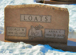

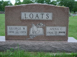
Anna Christina DeWall Loats
| Birth | : | 12 May 1906 |
| Death | : | 31 Mar 2005 |
| Burial | : | Humboldt Cemetery, Humboldt, Richardson County, USA |
| Coordinate | : | 40.1610985, -95.9578018 |
| Description | : | B: Dempster, SD. D: Watertown, SD. Buried: 04/04/05. Preceded by husb., George W. Loats 04/23/1973. They were married on 10/15/1924 in Wheaton, MN. |
frequently asked questions (FAQ):
-
Where is Anna Christina DeWall Loats's memorial?
Anna Christina DeWall Loats's memorial is located at: Humboldt Cemetery, Humboldt, Richardson County, USA.
-
When did Anna Christina DeWall Loats death?
Anna Christina DeWall Loats death on 31 Mar 2005 in
-
Where are the coordinates of the Anna Christina DeWall Loats's memorial?
Latitude: 40.1610985
Longitude: -95.9578018
Family Members:
Parent


Spouse
Siblings


Flowers:


Nearby Cemetories:
1. Humboldt Cemetery
Humboldt, Richardson County, USA
Coordinate: 40.1610985, -95.9578018
2. Longbranch Cemetery
Humboldt, Richardson County, USA
Coordinate: 40.1996000, -95.9740000
3. Lynchburg Cemetery
Humboldt, Richardson County, USA
Coordinate: 40.1306000, -95.9068985
4. Standerford Cemetery
Humboldt, Richardson County, USA
Coordinate: 40.2110000, -95.9656000
5. Dry Branch Pioneer Cemetery
Richardson County, USA
Coordinate: 40.1292000, -96.0100021
6. Bohemian Cemetery
Richardson County, USA
Coordinate: 40.1175003, -95.9955978
7. Bohemian Cemetery
Table Rock, Pawnee County, USA
Coordinate: 40.1786003, -96.0374985
8. Starr Cemetery
Dawson, Richardson County, USA
Coordinate: 40.1464005, -95.8692017
9. Mound Cemetery
Humboldt, Richardson County, USA
Coordinate: 40.1960983, -95.8602982
10. Saint Marys Cemetery
Dawson, Richardson County, USA
Coordinate: 40.1307983, -95.8414001
11. Heim Cemetery
Dawson, Richardson County, USA
Coordinate: 40.1380997, -95.8328018
12. Saint Johns Cemetery
Table Rock, Pawnee County, USA
Coordinate: 40.2148000, -96.0657000
13. East Amish Cemetery
Table Rock, Pawnee County, USA
Coordinate: 40.1310000, -96.0854000
14. Four Mile Cemetery
Humboldt, Richardson County, USA
Coordinate: 40.0589000, -95.9455000
15. Pleasant View Cemetery
Auburn, Nemaha County, USA
Coordinate: 40.2681007, -95.9163971
16. Table Rock Cemetery
Table Rock, Pawnee County, USA
Coordinate: 40.1791400, -96.1037400
17. Iliff Cemetery
Dawson, Richardson County, USA
Coordinate: 40.1241989, -95.8127975
18. Athens Cemetery
Richardson County, USA
Coordinate: 40.0449982, -95.9852982
19. Pleasant Hill Cemetery
Richardson County, USA
Coordinate: 40.0471992, -95.9075012
20. Mount Zion Cemetery
Nemaha County, USA
Coordinate: 40.2761002, -96.0113983
21. Saint James Lutheran Cemetery
Nemaha County, USA
Coordinate: 40.2757500, -96.0161500
22. Liberty Township Cemetery
Verdon, Richardson County, USA
Coordinate: 40.1597200, -95.7664100
23. Trinity Lutheran Cemetery
Nemaha County, USA
Coordinate: 40.3058014, -96.0093994
24. Clear Creek Cemetery
Table Rock, Pawnee County, USA
Coordinate: 40.2193985, -96.1391983