
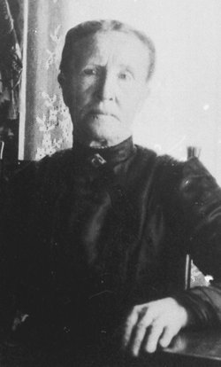
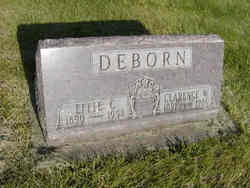
Anna Christina Kröner Deburn
| Birth | : | 6 Dec 1845 Kassel, Stadtkreis Kassel, Hessen, Germany |
| Death | : | 24 Aug 1922 Bonaparte, Van Buren County, Iowa, USA |
| Burial | : | Blessed Virgin Mary Churchyard, Charlcombe, Bath and North East Somerset Unitary Authority, England |
| Coordinate | : | 51.4046040, -2.3629440 |
| Plot | : | Section III |
| Description | : | Third wife to Frederick Gilbert Deborn. Anna, daughter of Mr. and Mrs. Kröner, who was born in Germany, Dec. 6, 1845, died in Bonaparte Iowa, Aug. 25, 1922, aged 76 years 8 months and 18 days. In company with her brothers she came to America at the close of the civil war and made her home in Ottumwa, Iowa, changing the spelling of her last name to Kraner. She was married to Mr. Adolph Kaiser, to which union was born one child which passed away in infancy. After the death of her husband she was married again to Mr. Gilbert Deborn, May... Read More |
frequently asked questions (FAQ):
-
Where is Anna Christina Kröner Deburn's memorial?
Anna Christina Kröner Deburn's memorial is located at: Blessed Virgin Mary Churchyard, Charlcombe, Bath and North East Somerset Unitary Authority, England.
-
When did Anna Christina Kröner Deburn death?
Anna Christina Kröner Deburn death on 24 Aug 1922 in Bonaparte, Van Buren County, Iowa, USA
-
Where are the coordinates of the Anna Christina Kröner Deburn's memorial?
Latitude: 51.4046040
Longitude: -2.3629440
Family Members:
Spouse
Children
Flowers:


Nearby Cemetories:
1. Lansdown Cemetery
Lansdown, Bath and North East Somerset Unitary Authority, England
Coordinate: 51.4063620, -2.3780520
2. All Saints Churchyard
Woolley, Bath and North East Somerset Unitary Authority, England
Coordinate: 51.4149600, -2.3612130
3. St. Mary the Blessed Virgin Churchyard
Swainswick, Bath and North East Somerset Unitary Authority, England
Coordinate: 51.4142080, -2.3514370
4. Independent Burial Ground Argyle Chapel
Bath, Bath and North East Somerset Unitary Authority, England
Coordinate: 51.3925420, -2.3536920
5. St Saviour's Church Crypt
Larkhall, Bath and North East Somerset Unitary Authority, England
Coordinate: 51.3956300, -2.3465100
6. Walcot Methodist Chapel Burial Ground
Bath, Bath and North East Somerset Unitary Authority, England
Coordinate: 51.3897080, -2.3579610
7. St. Swithin Churchyard
Bath, Bath and North East Somerset Unitary Authority, England
Coordinate: 51.3885480, -2.3594500
8. St. John the Baptist Churchyard
Bathwick, Bath and North East Somerset Unitary Authority, England
Coordinate: 51.3886890, -2.3547030
9. St. Mary's Churchyard
Bathwick, Bath and North East Somerset Unitary Authority, England
Coordinate: 51.3876120, -2.3543540
10. All Saints Churchyard
Weston, Bath and North East Somerset Unitary Authority, England
Coordinate: 51.3956850, -2.3881320
11. Moravian Burial Ground
Bath, Bath and North East Somerset Unitary Authority, England
Coordinate: 51.3894150, -2.3798150
12. Countess of Huntingdon's Chapel
Walcot, Bath and North East Somerset Unitary Authority, England
Coordinate: 51.3967020, -2.3907434
13. St. Michael's Burial Ground
Bath, Bath and North East Somerset Unitary Authority, England
Coordinate: 51.3838810, -2.3594090
14. St Mary Magdalene
Langridge, Bath and North East Somerset Unitary Authority, England
Coordinate: 51.4242860, -2.3750640
15. Ss Michael & Paul Churchyard
Bath, Bath and North East Somerset Unitary Authority, England
Coordinate: 51.3834970, -2.3596980
16. St Mary's Chapel, Queens Square
Bath, Bath and North East Somerset Unitary Authority, England
Coordinate: 51.3827790, -2.3649790
17. St. Michael's Cemetery
Bath, Bath and North East Somerset Unitary Authority, England
Coordinate: 51.3859700, -2.3814500
18. Bath General Hospital Burial Ground
Bath and North East Somerset Unitary Authority, England
Coordinate: 51.3824715, -2.3614742
19. Quaker Meeting House
Bath, Bath and North East Somerset Unitary Authority, England
Coordinate: 51.3823280, -2.3604380
20. Locksbrook St Saviour's Cemetery
Bath and North East Somerset Unitary Authority, England
Coordinate: 51.3867880, -2.3863380
21. Bath Abbey
Bath, Bath and North East Somerset Unitary Authority, England
Coordinate: 51.3815310, -2.3586640
22. St. Mary de Stall Churchyard (Defunct)
Bath, Bath and North East Somerset Unitary Authority, England
Coordinate: 51.3813350, -2.3600353
23. Locksbrook Cemetery
Lower Weston, Bath and North East Somerset Unitary Authority, England
Coordinate: 51.3845180, -2.3850300
24. Old Orchard Street Catholic Burial Vault
Bath, Bath and North East Somerset Unitary Authority, England
Coordinate: 51.3800370, -2.3579910