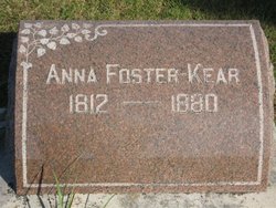
Anna Johnson Kear
| Birth | : | 1812 Ohio, USA |
| Death | : | 17 Sep 1880 Syracuse, Otoe County, Nebraska, USA |
| Burial | : | South Lawn Cemetery, Coshocton, Coshocton County, USA |
| Coordinate | : | 40.2560997, -81.8597031 |
| Plot | : | Lot 359 |
| Description | : | Daughter of Joel Johnson and Elizabeth Cornelius Anna married Samuel Foster 27 Jan 1831 in Harrison County, Ohio. Anna and Samuel were the parents of Joel, Rachel, Mary, Martha, and Samuel. Anna married William Reed Kear between 1861 & 1865. They had no children together. Syracuse Journal - 24 Sep 1880 Mrs. Anne Kear, wife of W.R. Kear, died at her home in Syracuse last Friday night the 17th inst., from paralysis. Mrs. Kear had been afflicted with poor health for seven or eight years past and was very sick for about three weeks previous to her death.... Read More |
frequently asked questions (FAQ):
-
Where is Anna Johnson Kear's memorial?
Anna Johnson Kear's memorial is located at: South Lawn Cemetery, Coshocton, Coshocton County, USA.
-
When did Anna Johnson Kear death?
Anna Johnson Kear death on 17 Sep 1880 in Syracuse, Otoe County, Nebraska, USA
-
Where are the coordinates of the Anna Johnson Kear's memorial?
Latitude: 40.2560997
Longitude: -81.8597031
Family Members:
Parent
Spouse
Siblings
Flowers:
Nearby Cemetories:
1. Oak Ridge Cemetery
Coshocton, Coshocton County, USA
Coordinate: 40.2780991, -81.8610992
2. Caldersburg Cemetery
Roscoe, Coshocton County, USA
Coordinate: 40.2755390, -81.8798700
3. Unidentified Cemetery #1
Coshocton, Coshocton County, USA
Coordinate: 40.2753080, -81.8803050
4. Roscoe Cemetery
Coshocton, Coshocton County, USA
Coordinate: 40.2821000, -81.8841000
5. Coshocton County Infirmary Cemetery
Coshocton, Coshocton County, USA
Coordinate: 40.2694450, -81.8166500
6. Warner Methodist Cemetery
Conesville, Coshocton County, USA
Coordinate: 40.2389520, -81.9109620
7. Tyndall Cemetery
Coshocton County, USA
Coordinate: 40.2167015, -81.8843994
8. Davis Cemetery
Conesville, Coshocton County, USA
Coordinate: 40.2154312, -81.8808899
9. Mount Zion Cemetery
Coshocton, Coshocton County, USA
Coordinate: 40.2344017, -81.8035965
10. Canal Lewisville Cemetery
Canal Lewisville, Coshocton County, USA
Coordinate: 40.3012500, -81.8357100
11. Saint Pauls Cemetery
Coshocton County, USA
Coordinate: 40.2103004, -81.8208008
12. Franklin Cemetery
Franklin, Coshocton County, USA
Coordinate: 40.2000008, -81.8460999
13. Christian Chapel Cemetery
Coshocton County, USA
Coordinate: 40.2271470, -81.9263480
14. Littick Cemetery
Franklin, Coshocton County, USA
Coordinate: 40.1991870, -81.8416490
15. Prairie Chapel Church Cemetery
Coshocton, Coshocton County, USA
Coordinate: 40.3049000, -81.9124000
16. Oak Grove Cemetery
Coshocton County, USA
Coordinate: 40.3032990, -81.8005981
17. Reamer Cemetery
Coshocton County, USA
Coordinate: 40.3194008, -81.8317032
18. Pleasant Hill Baptist Cemetery
Coshocton, Coshocton County, USA
Coordinate: 40.2547380, -81.9496810
19. Bethany Cemetery
Wills Creek, Coshocton County, USA
Coordinate: 40.1852989, -81.8591995
20. Coshocton County Memory Gardens
Coshocton, Coshocton County, USA
Coordinate: 40.3234825, -81.8310089
21. Royers Chapel Cemetery
Wills Creek, Coshocton County, USA
Coordinate: 40.1850014, -81.8319016
22. Machpelahs Burial Acres
Keene, Coshocton County, USA
Coordinate: 40.3208950, -81.9126210
23. Saint Johns Lutheran Church Cemetery
Coshocton, Coshocton County, USA
Coordinate: 40.2103200, -81.7796000
24. Our Lady of Lourdes Cemetery
Wills Creek, Coshocton County, USA
Coordinate: 40.1909870, -81.8048660


