
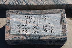
Anna Marie Louise “Lizzie” Stork Dahlkoetter
| Birth | : | 30 Dec 1872 |
| Death | : | 26 Apr 1966 |
| Burial | : | Trinity Lutheran Cemetery, Grant, Perkins County, USA |
| Coordinate | : | 40.9605000, -101.7478000 |
| Description | : | Mrs. Dahlkoetter was the daughter of Elizabine and Wm. Stork, born Dec 30, 1872, near Arlington, Nebraska, and passed away on April 26, 2966 at the Perkins County Hospital in Grant at the age of 93, 3 months and 26 days. Lizzie, as she was affectionately called, attended St. Paul's Lutheran Church and school of Arlington. Mrs. Dahlkoetter was confirmed in the Lutheran faith on April 28, 1887. Her confirmation verse, Isaiah 41:10, has been a beacon and guide in her life. "Fear thou not, for I am with thee; be not dismayed; For I am thy God; I will strengthen... Read More |
frequently asked questions (FAQ):
-
Where is Anna Marie Louise “Lizzie” Stork Dahlkoetter's memorial?
Anna Marie Louise “Lizzie” Stork Dahlkoetter's memorial is located at: Trinity Lutheran Cemetery, Grant, Perkins County, USA.
-
When did Anna Marie Louise “Lizzie” Stork Dahlkoetter death?
Anna Marie Louise “Lizzie” Stork Dahlkoetter death on 26 Apr 1966 in
-
Where are the coordinates of the Anna Marie Louise “Lizzie” Stork Dahlkoetter's memorial?
Latitude: 40.9605000
Longitude: -101.7478000
Family Members:
Parent

Spouse
Siblings
Children
Flowers:


Nearby Cemetories:
1. Trinity Lutheran Cemetery
Grant, Perkins County, USA
Coordinate: 40.9605000, -101.7478000
2. Fairview Cemetery
Grant, Perkins County, USA
Coordinate: 40.8372002, -101.7391968
3. Saint John's Lutheran Church Cemetery
Ogallala, Keith County, USA
Coordinate: 41.0617000, -101.5983000
4. Ogallala Cemetery
Ogallala, Keith County, USA
Coordinate: 41.1286011, -101.7472000
5. Boot Hill Cemetery
Ogallala, Keith County, USA
Coordinate: 41.1324997, -101.7256012
6. Brule Cemetery
Brule, Keith County, USA
Coordinate: 41.1060982, -101.8822021
7. Madrid Cemetery
Madrid, Perkins County, USA
Coordinate: 40.8371510, -101.5380900
8. Pickard Cemetery
Keith County, USA
Coordinate: 41.0482240, -101.4809320
9. Big Springs Cemetery
Big Springs, Deuel County, USA
Coordinate: 41.0592003, -102.0931015
10. Venango Cemetery
Venango, Perkins County, USA
Coordinate: 40.7416992, -102.0175018
11. Elsie Cemetery
Elsie, Perkins County, USA
Coordinate: 40.8499050, -101.3666140
12. Walpole Cemetery
Perkins County, USA
Coordinate: 40.9157982, -101.3422012
13. Lemoyne Cemetery
Lemoyne, Keith County, USA
Coordinate: 41.2723000, -101.8123000
14. Paxton Cemetery
Paxton, Keith County, USA
Coordinate: 41.1088982, -101.3569031
15. Blanche Cemetery
Chase County, USA
Coordinate: 40.6841900, -101.4390900
16. Zion Cemetery
Deuel County, USA
Coordinate: 41.1641998, -102.1530991
17. Day Cemetery
Deuel County, USA
Coordinate: 41.1921997, -102.1331024
18. Hillside Cemetery
Julesburg, Sedgwick County, USA
Coordinate: 40.9692001, -102.2406006
19. Green Cemetery
Julesburg, Sedgwick County, USA
Coordinate: 40.8650000, -102.2284090
20. Frontier Cemetery
Sutherland, Lincoln County, USA
Coordinate: 41.0912000, -101.2531000
21. Amherst Cemetery
Phillips County, USA
Coordinate: 40.7056007, -102.1603012
22. Chase Cemetery
Chase, Chase County, USA
Coordinate: 40.5525017, -101.8078003
23. Dunkard Cemetery
Amherst, Phillips County, USA
Coordinate: 40.6438000, -102.1356400
24. Mount Hope Cemetery
Imperial, Chase County, USA
Coordinate: 40.5297012, -101.6607971