
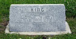
Anna Smith King
| Birth | : | 4 Aug 1863 Congerville, Woodford County, Illinois, USA |
| Death | : | 25 Nov 1949 Newton, Harvey County, Kansas, USA |
| Burial | : | Saint Mary Cemetery, Union County, USA |
| Coordinate | : | 42.8520584, -96.7877502 |
| Plot | : | 102-2 |
| Description | : | King, -- Anna, daughter of Peter and Barbara (Neuhauser) Smith, was born near Congerville, Ill., Aug. 4, 1863; passed away at the Bethel Hospital, Newton, Kans., Nov. 25, 1949; aged 86 y. 3 m. 21 d. In 1885 she was married to Samuel B. King and moved from Illinois to Kansas, where they found their home near Larned. Ten years later they located on a farm near Hesston, which was their home until the time of her husband's death in 1942, after which she lived with her daughter (Mrs. Ephraim Risser). Funeral services were conducted at the home by O.... Read More |
frequently asked questions (FAQ):
-
Where is Anna Smith King's memorial?
Anna Smith King's memorial is located at: Saint Mary Cemetery, Union County, USA.
-
When did Anna Smith King death?
Anna Smith King death on 25 Nov 1949 in Newton, Harvey County, Kansas, USA
-
Where are the coordinates of the Anna Smith King's memorial?
Latitude: 42.8520584
Longitude: -96.7877502
Family Members:
Parent
Spouse

Siblings
Children
Flowers:


Nearby Cemetories:
1. Saint Mary Cemetery
Union County, USA
Coordinate: 42.8520584, -96.7877502
2. Ahlsborg Lutheran Cemetery
Union County, USA
Coordinate: 42.8228000, -96.7612000
3. Brule Creek Cemetery
Spink Township, Union County, USA
Coordinate: 42.8346510, -96.7324350
4. Pleasant Hill Cemetery Old
Spink, Union County, USA
Coordinate: 42.8588462, -96.7215592
5. Saint Peter Greenfield Cemetery
Vermillion, Clay County, USA
Coordinate: 42.8608017, -96.8644028
6. Dowlin Cemetery
Burbank, Clay County, USA
Coordinate: 42.7789001, -96.8107986
7. Pleasant Hill Cemetery
Spink, Union County, USA
Coordinate: 42.8741000, -96.6876000
8. Saint Agnes Cemetery
Vermillion, Clay County, USA
Coordinate: 42.7872009, -96.8499985
9. Olbue Lerseth Cemetery
Beresford, Union County, USA
Coordinate: 42.9281100, -96.7516100
10. First Brule Creek Cemetery
Elk Point, Union County, USA
Coordinate: 42.7943993, -96.7069016
11. Roseni Lutheran Church Cemetery
Beresford, Union County, USA
Coordinate: 42.9388000, -96.7639000
12. Rockfield Cemetery
Clay County, USA
Coordinate: 42.9397011, -96.8302994
13. Clay Point Cemetery
Prairie Center Township, Clay County, USA
Coordinate: 42.8987700, -96.9065600
14. Nora Cemetery
Union County, USA
Coordinate: 42.9314003, -96.7061005
15. Union County Poor Farm Cemetery
Union County, USA
Coordinate: 42.7649210, -96.7077580
16. Saint Paul Cemetery
Elk Point, Union County, USA
Coordinate: 42.7641983, -96.7061005
17. Bluff View Cemetery
Vermillion, Clay County, USA
Coordinate: 42.7714000, -96.9056000
18. Saint Agnes Calvary Cemetery
Vermillion, Clay County, USA
Coordinate: 42.7715900, -96.9072100
19. Spirit Mound Cemetery
Clay County, USA
Coordinate: 42.8885994, -96.9424973
20. Richland Cemetery
Richland, Union County, USA
Coordinate: 42.7682991, -96.6624985
21. Gores Bluff Cemetery
Union County, USA
Coordinate: 42.8035069, -96.6260468
22. Dalesburg Lutheran Cemetery
Vermillion, Clay County, USA
Coordinate: 42.9389424, -96.9242594
23. Saint Joseph Catholic Church Cemetery
Emmet, Union County, USA
Coordinate: 42.9836950, -96.7466350
24. Dalesburg Baptist Cemetery
Dalesburg, Clay County, USA
Coordinate: 42.9675102, -96.8850403