
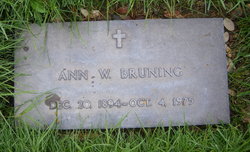

Anna Wolfe “Ann” Bell Bruning
| Birth | : | 20 Dec 1894 Lafayette Township, Keokuk County, Iowa, USA |
| Death | : | 4 Oct 1975 Sparta, Monroe County, Wisconsin, USA |
| Burial | : | St Laurence Church, Appleton, Vale of White Horse District, England |
| Coordinate | : | 51.7110290, -1.3588780 |
| Plot | : | Veterans Section |
frequently asked questions (FAQ):
-
Where is Anna Wolfe “Ann” Bell Bruning's memorial?
Anna Wolfe “Ann” Bell Bruning's memorial is located at: St Laurence Church, Appleton, Vale of White Horse District, England.
-
When did Anna Wolfe “Ann” Bell Bruning death?
Anna Wolfe “Ann” Bell Bruning death on 4 Oct 1975 in Sparta, Monroe County, Wisconsin, USA
-
Where are the coordinates of the Anna Wolfe “Ann” Bell Bruning's memorial?
Latitude: 51.7110290
Longitude: -1.3588780
Family Members:
Parent

Spouse
Siblings
Flowers:


Nearby Cemetories:
1. St Laurence Church
Appleton, Vale of White Horse District, England
Coordinate: 51.7110290, -1.3588780
2. Saint Lawrence Churchyard
Bessels Leigh, Vale of White Horse District, England
Coordinate: 51.7065220, -1.3409750
3. St. Lawrence Churchyard
Tubney, Vale of White Horse District, England
Coordinate: 51.6903100, -1.3712600
4. St. Denys' Churchyard
Northmoor, West Oxfordshire District, England
Coordinate: 51.7230000, -1.3918000
5. St. Helen Churchyard
Dry Sandford, Vale of White Horse District, England
Coordinate: 51.7003000, -1.3247100
6. St Michael Churchyard
Cumnor, Vale of White Horse District, England
Coordinate: 51.7340384, -1.3331002
7. St Peter's Churchyard
Wootton, Vale of White Horse District, England
Coordinate: 51.7091400, -1.3118200
8. St Nicholas Churchyard
Fyfield, Vale of White Horse District, England
Coordinate: 51.6871100, -1.3888600
9. All Saints Churchyard
Marcham, Vale of White Horse District, England
Coordinate: 51.6676980, -1.3496990
10. St Michael's Churchyard
Stanton Harcourt, West Oxfordshire District, England
Coordinate: 51.7480000, -1.3977000
11. St. John the Baptist Churchyard
Kingston Bagpuize, Vale of White Horse District, England
Coordinate: 51.6820690, -1.4127410
12. St. Giles' Churchyard
Standlake, West Oxfordshire District, England
Coordinate: 51.7299550, -1.4262300
13. St. Mary Magdalene Churchyard
Shippon, Vale of White Horse District, England
Coordinate: 51.6788360, -1.3060940
14. St Leonard's Churchyard
Sunningwell, Vale of White Horse District, England
Coordinate: 51.7013600, -1.2840500
15. St. Luke's Churchyard
Garford, Vale of White Horse District, England
Coordinate: 51.6637514, -1.3815467
16. Spring Garden Cemetery
Abingdon, Vale of White Horse District, England
Coordinate: 51.6750410, -1.2970850
17. Spring Road Cemetery
Abingdon, Vale of White Horse District, England
Coordinate: 51.6722620, -1.2951410
18. Saint Mary Churchyard
Longworth, Vale of White Horse District, England
Coordinate: 51.6926577, -1.4457428
19. St. Lawrence's Churchyard
North Hinksey, Vale of White Horse District, England
Coordinate: 51.7457590, -1.2848020
20. Botley Cemetery
Botley, Vale of White Horse District, England
Coordinate: 51.7518050, -1.2930000
21. South Oxfordshire Memorial Park and Crematorium
Garford, Vale of White Horse District, England
Coordinate: 51.6535980, -1.3767840
22. Abingdon Baptist Church Burial Ground
Abingdon, Vale of White Horse District, England
Coordinate: 51.6700100, -1.2870810
23. Abingdon War Memorial
Abingdon, Vale of White Horse District, England
Coordinate: 51.6702940, -1.2839070
24. Our Lady and St Edmund of Abingdon Roman Catholic
Abingdon, Vale of White Horse District, England
Coordinate: 51.6747940, -1.2776270