
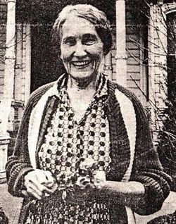
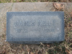
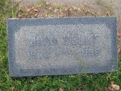
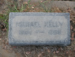
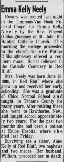
Anne Kelly
| Birth | : | 20 Sep 1879 Red Bluff, Tehama County, California, USA |
| Death | : | 22 Apr 1988 Rancho Cordova, Sacramento County, California, USA |
| Burial | : | Saint Mary's Cemetery, Red Bluff, Tehama County, USA |
| Coordinate | : | 40.1716995, -122.2521973 |
| Description | : | Anne Kelly Funeral services for Anne Kelly who lived in the Sacramento area for most of her life and was a longtime public school teacher will be held at 11 am today in the Klumpp Chapel Riverside Boulevard and 2nd Avenue. Burial will be at St Mary’s Cemetery. Miss Kelly was born in Red Bluff and died Friday in a Rancho Cordova convalescent hospital at age 108. She has no survivors . The Sacramento Bee, 26 April 1988 |
frequently asked questions (FAQ):
-
Where is Anne Kelly's memorial?
Anne Kelly's memorial is located at: Saint Mary's Cemetery, Red Bluff, Tehama County, USA.
-
When did Anne Kelly death?
Anne Kelly death on 22 Apr 1988 in Rancho Cordova, Sacramento County, California, USA
-
Where are the coordinates of the Anne Kelly's memorial?
Latitude: 40.1716995
Longitude: -122.2521973
Family Members:
Parent

Siblings
Flowers:


Nearby Cemetories:
1. Saint Mary's Cemetery
Red Bluff, Tehama County, USA
Coordinate: 40.1716995, -122.2521973
2. Red Bluff Memorial Chapel Mausoleum & Columbarium
Red Bluff, Tehama County, USA
Coordinate: 40.1717130, -122.2466860
3. Oak Hill Cemetery
Red Bluff, Tehama County, USA
Coordinate: 40.1699982, -122.2433014
4. Growney Ranch Family Cemetery
Red Bluff, Tehama County, USA
Coordinate: 40.1167300, -122.1952500
5. Red Bank Cemetery
Red Bank, Tehama County, USA
Coordinate: 40.1036970, -122.4458540
6. Los Molinos Cemetery
Los Molinos, Tehama County, USA
Coordinate: 40.0475650, -122.1011820
7. Tehama Cemetery
Tehama, Tehama County, USA
Coordinate: 40.0233002, -122.1433029
8. Inks Creek Cemetery
Tehama County, USA
Coordinate: 40.3419800, -122.1297100
9. Cottonwood Creek Ranch Cemetery
Cottonwood, Shasta County, USA
Coordinate: 40.3663100, -122.2598800
10. Cottonwood Cemetery
Cottonwood, Shasta County, USA
Coordinate: 40.3856100, -122.2936500
11. Major Pierson B Reading Family Cemetery
Cottonwood, Shasta County, USA
Coordinate: 40.3924300, -122.2126900
12. Sleepy Hollow Pet Cemetery
Anderson, Shasta County, USA
Coordinate: 40.4199430, -122.2858410
13. Rosewood Cemetery
Rosewood, Tehama County, USA
Coordinate: 40.2685360, -122.5575190
14. Sunset Hill Cemetery
Corning, Tehama County, USA
Coordinate: 39.9271600, -122.1586100
15. Anderson District Cemetery
Anderson, Shasta County, USA
Coordinate: 40.4419518, -122.2967300
16. Oddfellows Cemetery
Anderson, Shasta County, USA
Coordinate: 40.4431590, -122.2907070
17. Anderson Pioneer Cemetery
Anderson, Shasta County, USA
Coordinate: 40.4439011, -122.2904968
18. New Clairvaux Abbey Cemetery
Vina, Tehama County, USA
Coordinate: 39.9381450, -122.0641890
19. Vina Cemetery
Vina, Tehama County, USA
Coordinate: 39.9636440, -121.9957070
20. Lowrey Cemetery
Tehama County, USA
Coordinate: 40.0066986, -122.5635986
21. Parkville Cemetery
Anderson, Shasta County, USA
Coordinate: 40.4640200, -122.1897500
22. Cameron-Davis Cemetery
Tehama County, USA
Coordinate: 40.2709800, -121.8778500
23. Pinckney Cemetery
Cottonwood, Shasta County, USA
Coordinate: 40.3997002, -122.5180969
24. Lanes Valley Cemetery
Paynes Creek, Tehama County, USA
Coordinate: 40.3998400, -121.9762400