
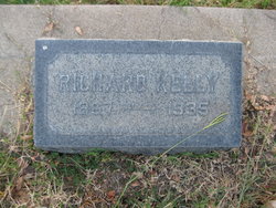
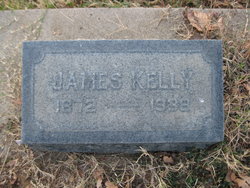
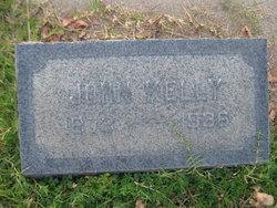
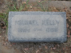
Richard “Dick” Kelly
| Birth | : | 29 Jul 1867 Australia |
| Death | : | 30 Jul 1935 Lassen County, California, USA |
| Burial | : | Saint Mary's Cemetery, Red Bluff, Tehama County, USA |
| Coordinate | : | 40.1716995, -122.2521973 |
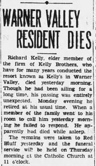
| Description | : | Chico Record (Chico, California) 31 Jul 1935, Wednesday Page 2 (continued): "Dick" Kelly was widely known, as he had been a summer resident of Warner Valley for nearly 50 years. His parents, James and Katherine Kelly, acquired the property there more than 50 years ago, and after their death the children continued to make it a popular resort for those enjoying the outdoor mountain life. Deceased was 68 years of age and was born in Australia. With his parents he arrived at San Francisco when he was three years old. The family then moved to... Read More |
frequently asked questions (FAQ):
-
Where is Richard “Dick” Kelly's memorial?
Richard “Dick” Kelly's memorial is located at: Saint Mary's Cemetery, Red Bluff, Tehama County, USA.
-
When did Richard “Dick” Kelly death?
Richard “Dick” Kelly death on 30 Jul 1935 in Lassen County, California, USA
-
Where are the coordinates of the Richard “Dick” Kelly's memorial?
Latitude: 40.1716995
Longitude: -122.2521973
Family Members:
Parent

Siblings
Flowers:


Nearby Cemetories:
1. Saint Mary's Cemetery
Red Bluff, Tehama County, USA
Coordinate: 40.1716995, -122.2521973
2. Red Bluff Memorial Chapel Mausoleum & Columbarium
Red Bluff, Tehama County, USA
Coordinate: 40.1717130, -122.2466860
3. Oak Hill Cemetery
Red Bluff, Tehama County, USA
Coordinate: 40.1699982, -122.2433014
4. Growney Ranch Family Cemetery
Red Bluff, Tehama County, USA
Coordinate: 40.1167300, -122.1952500
5. Red Bank Cemetery
Red Bank, Tehama County, USA
Coordinate: 40.1036970, -122.4458540
6. Los Molinos Cemetery
Los Molinos, Tehama County, USA
Coordinate: 40.0475650, -122.1011820
7. Tehama Cemetery
Tehama, Tehama County, USA
Coordinate: 40.0233002, -122.1433029
8. Inks Creek Cemetery
Tehama County, USA
Coordinate: 40.3419800, -122.1297100
9. Cottonwood Creek Ranch Cemetery
Cottonwood, Shasta County, USA
Coordinate: 40.3663100, -122.2598800
10. Cottonwood Cemetery
Cottonwood, Shasta County, USA
Coordinate: 40.3856100, -122.2936500
11. Major Pierson B Reading Family Cemetery
Cottonwood, Shasta County, USA
Coordinate: 40.3924300, -122.2126900
12. Sleepy Hollow Pet Cemetery
Anderson, Shasta County, USA
Coordinate: 40.4199430, -122.2858410
13. Rosewood Cemetery
Rosewood, Tehama County, USA
Coordinate: 40.2685360, -122.5575190
14. Sunset Hill Cemetery
Corning, Tehama County, USA
Coordinate: 39.9271600, -122.1586100
15. Anderson District Cemetery
Anderson, Shasta County, USA
Coordinate: 40.4419518, -122.2967300
16. Oddfellows Cemetery
Anderson, Shasta County, USA
Coordinate: 40.4431590, -122.2907070
17. Anderson Pioneer Cemetery
Anderson, Shasta County, USA
Coordinate: 40.4439011, -122.2904968
18. New Clairvaux Abbey Cemetery
Vina, Tehama County, USA
Coordinate: 39.9381450, -122.0641890
19. Vina Cemetery
Vina, Tehama County, USA
Coordinate: 39.9636440, -121.9957070
20. Lowrey Cemetery
Tehama County, USA
Coordinate: 40.0066986, -122.5635986
21. Parkville Cemetery
Anderson, Shasta County, USA
Coordinate: 40.4640200, -122.1897500
22. Cameron-Davis Cemetery
Tehama County, USA
Coordinate: 40.2709800, -121.8778500
23. Pinckney Cemetery
Cottonwood, Shasta County, USA
Coordinate: 40.3997002, -122.5180969
24. Lanes Valley Cemetery
Paynes Creek, Tehama County, USA
Coordinate: 40.3998400, -121.9762400