
Annie E. Pope Perdew
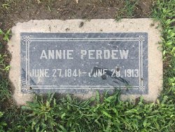
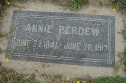
| Birth | : | 27 Jun 1841 Hillsboro, Highland County, Ohio, USA |
| Death | : | 28 Jun 1913 San Bernardino, San Bernardino County, California, USA |
| Burial | : | Redhill Cemetery, Redhill, Port Pirie Regional Council, Australia |
| Coordinate | : | -33.5577780, 138.2382590 |
| Plot | : | Block 3, Lot 2, Aisle 3 (Old City Cemetery) |
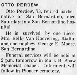
| Description | : | Annie was the eldest of five children born to Samuel E. Pope and Mary Ann Trickey, who were married on Jul. 13, 1841 in Licking, OH. Samuel and Mary Pope's children were: 1) Ann E. Pope, b. Jun. 27, 1841 in Hillsboro, Highland Co., OH. and d. Jun. 28, 1913 in San Bernardino, San Bernardino Co., CA. 2) Lowell E. Pope, b. Apr. 1849 in IA. 3) George W. Pope, b. abt. 1853 in IA. 4) Samuel M. Pope, b. Mar. 5, 1855 in IA. and d. Jan. 2, 1929 in Carthage, Hancock Co., IL. 5)... Read More |
frequently asked questions (FAQ):
-
Where is Annie E. Pope Perdew's memorial?
Annie E. Pope Perdew's memorial is located at: Redhill Cemetery, Redhill, Port Pirie Regional Council, Australia.
-
When did Annie E. Pope Perdew death?
Annie E. Pope Perdew death on 28 Jun 1913 in San Bernardino, San Bernardino County, California, USA
-
Where are the coordinates of the Annie E. Pope Perdew's memorial?
Latitude: -33.5577780
Longitude: 138.2382590
Family Members:
Spouse
Children
Flowers:


Nearby Cemetories:
1. Redhill Cemetery
Redhill, Port Pirie Regional Council, Australia
Coordinate: -33.5577780, 138.2382590
2. St. Martin's Catholic Cemetery
Redhill, Port Pirie Regional Council, Australia
Coordinate: -33.5448740, 138.2263270
3. Koolunga Cemetery
Koolunga, Port Pirie Regional Council, Australia
Coordinate: -33.5746380, 138.3417300
4. Keilli Cemetery
Mundoora, District Council of Barunga West, Australia
Coordinate: -33.6002884, 138.1451721
5. Narridy Cemetery
Narridy, Northern Areas Council, Australia
Coordinate: -33.4379450, 138.3188360
6. Yacka Cemetery
Koolunga, Port Pirie Regional Council, Australia
Coordinate: -33.5812770, 138.4512500
7. Saint John Lutheran Cemetery
Condowie, Wakefield Regional Council, Australia
Coordinate: -33.7319540, 138.3293020
8. Crystal Brook Cemetery
Crystal Brook, Port Pirie Regional Council, Australia
Coordinate: -33.3548793, 138.2235864
9. Angle Grove Cemetery
Brinkworth, Wakefield Regional Council, Australia
Coordinate: -33.6765530, 138.4376980
10. Condowie Cemetery
Condowie, Wakefield Regional Council, Australia
Coordinate: -33.7770500, 138.2748200
11. Bowmans Head Station Cemetery
Crystal Brook, Port Pirie Regional Council, Australia
Coordinate: -33.3354850, 138.2204820
12. Georgetown Cemetery
Georgetown, Northern Areas Council, Australia
Coordinate: -33.3695000, 138.3949000
13. Gladstone Cemetery
Gladstone, Northern Areas Council, Australia
Coordinate: -33.2954960, 138.3519350
14. Barunga Gap Cemetery
Barunga Gap, Wakefield Regional Council, Australia
Coordinate: -33.8298400, 138.1150070
15. Salt Lake Cemetery
Bumbunga, Wakefield Regional Council, Australia
Coordinate: -33.8504642, 138.2017451
16. St Michaels Anglican Church Cemetery
Bungaree, District Council of Clare and Gilbert Valleys, Australia
Coordinate: -33.7439580, 138.5616060
17. Blyth Cemetery
Blyth, Wakefield Regional Council, Australia
Coordinate: -33.8261460, 138.4943480
18. Warnertown Cemetery
Port Pirie, Port Pirie Regional Council, Australia
Coordinate: -33.2273000, 138.1073000
19. Bute Cemetery
Bute, District Council of Barunga West, Australia
Coordinate: -33.8716030, 137.9918400
20. Laura Cemetery
Laura, Northern Areas Council, Australia
Coordinate: -33.1875590, 138.3137920
21. Stanley Flat Gaelic Cemetery
Clare, District Council of Clare and Gilbert Valleys, Australia
Coordinate: -33.7915580, 138.6066290
22. Lochiel Cemetery
Wakefield Regional Council, Australia
Coordinate: -33.9475210, 138.1576680
23. White Hut Cemetery
Stanley Flat, District Council of Clare and Gilbert Valleys, Australia
Coordinate: -33.7971650, 138.6234010
24. White Hut Gaelic Cemetery
Clare, District Council of Clare and Gilbert Valleys, Australia
Coordinate: -33.8040010, 138.6283890