
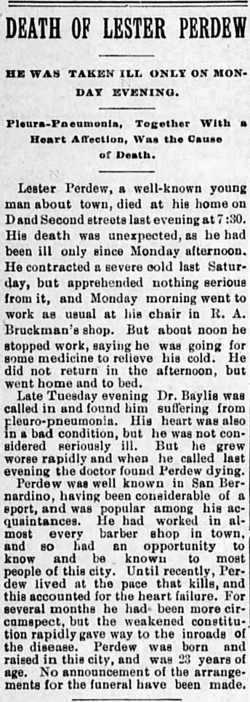
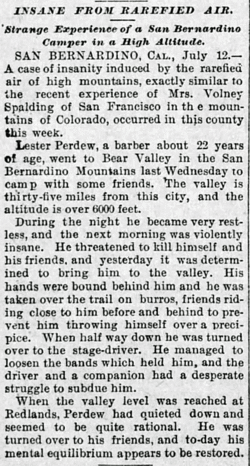
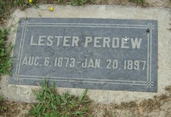
Lester Perdew
| Birth | : | 6 Aug 1873 San Bernardino, San Bernardino County, California, USA |
| Death | : | 20 Jan 1897 San Bernardino, San Bernardino County, California, USA |
| Burial | : | Redhill Cemetery, Redhill, Port Pirie Regional Council, Australia |
| Coordinate | : | -33.5577780, 138.2382590 |
| Plot | : | Block 3, Lot 2, Aisle 3, Family Plot #1 |
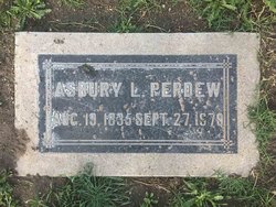
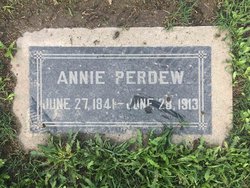
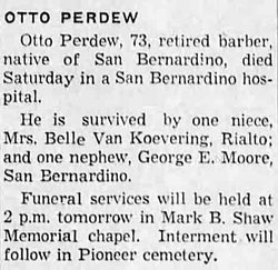
| Description | : | Lester was a barber by occupation. According to the 1880 U.S. census, Lester's father, Asbury, had died and 7 yr. old Lester Perdue, b. in CA., was living in San Bernardino, San Bernardino, CA. with his 38 yr. old widowed mother, Mrs. A. L. Perdue, working in boarding & lodging, b. abt. 1842 in OH. 16 yr. old sister, Mattie Perdue, a dressmaker, b. in IA. 14 yr. old sister, Hattie Perdue, b. in CA. 12 yr. old sister, Lizzie Perdue, b. in CA. 9 yr. old brother, Robt. Lee Perdue, b. in CA. 4 yr. old brother, Otto Perdue, b. in CA.... Read More |
frequently asked questions (FAQ):
-
Where is Lester Perdew's memorial?
Lester Perdew's memorial is located at: Redhill Cemetery, Redhill, Port Pirie Regional Council, Australia.
-
When did Lester Perdew death?
Lester Perdew death on 20 Jan 1897 in San Bernardino, San Bernardino County, California, USA
-
Where are the coordinates of the Lester Perdew's memorial?
Latitude: -33.5577780
Longitude: 138.2382590
Family Members:
Parent
Siblings
Flowers:


Nearby Cemetories:
1. Redhill Cemetery
Redhill, Port Pirie Regional Council, Australia
Coordinate: -33.5577780, 138.2382590
2. St. Martin's Catholic Cemetery
Redhill, Port Pirie Regional Council, Australia
Coordinate: -33.5448740, 138.2263270
3. Koolunga Cemetery
Koolunga, Port Pirie Regional Council, Australia
Coordinate: -33.5746380, 138.3417300
4. Keilli Cemetery
Mundoora, District Council of Barunga West, Australia
Coordinate: -33.6002884, 138.1451721
5. Narridy Cemetery
Narridy, Northern Areas Council, Australia
Coordinate: -33.4379450, 138.3188360
6. Yacka Cemetery
Koolunga, Port Pirie Regional Council, Australia
Coordinate: -33.5812770, 138.4512500
7. Saint John Lutheran Cemetery
Condowie, Wakefield Regional Council, Australia
Coordinate: -33.7319540, 138.3293020
8. Crystal Brook Cemetery
Crystal Brook, Port Pirie Regional Council, Australia
Coordinate: -33.3548793, 138.2235864
9. Angle Grove Cemetery
Brinkworth, Wakefield Regional Council, Australia
Coordinate: -33.6765530, 138.4376980
10. Condowie Cemetery
Condowie, Wakefield Regional Council, Australia
Coordinate: -33.7770500, 138.2748200
11. Bowmans Head Station Cemetery
Crystal Brook, Port Pirie Regional Council, Australia
Coordinate: -33.3354850, 138.2204820
12. Georgetown Cemetery
Georgetown, Northern Areas Council, Australia
Coordinate: -33.3695000, 138.3949000
13. Gladstone Cemetery
Gladstone, Northern Areas Council, Australia
Coordinate: -33.2954960, 138.3519350
14. Barunga Gap Cemetery
Barunga Gap, Wakefield Regional Council, Australia
Coordinate: -33.8298400, 138.1150070
15. Salt Lake Cemetery
Bumbunga, Wakefield Regional Council, Australia
Coordinate: -33.8504642, 138.2017451
16. St Michaels Anglican Church Cemetery
Bungaree, District Council of Clare and Gilbert Valleys, Australia
Coordinate: -33.7439580, 138.5616060
17. Blyth Cemetery
Blyth, Wakefield Regional Council, Australia
Coordinate: -33.8261460, 138.4943480
18. Warnertown Cemetery
Port Pirie, Port Pirie Regional Council, Australia
Coordinate: -33.2273000, 138.1073000
19. Bute Cemetery
Bute, District Council of Barunga West, Australia
Coordinate: -33.8716030, 137.9918400
20. Laura Cemetery
Laura, Northern Areas Council, Australia
Coordinate: -33.1875590, 138.3137920
21. Stanley Flat Gaelic Cemetery
Clare, District Council of Clare and Gilbert Valleys, Australia
Coordinate: -33.7915580, 138.6066290
22. Lochiel Cemetery
Wakefield Regional Council, Australia
Coordinate: -33.9475210, 138.1576680
23. White Hut Cemetery
Stanley Flat, District Council of Clare and Gilbert Valleys, Australia
Coordinate: -33.7971650, 138.6234010
24. White Hut Gaelic Cemetery
Clare, District Council of Clare and Gilbert Valleys, Australia
Coordinate: -33.8040010, 138.6283890