
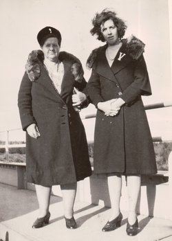


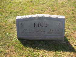
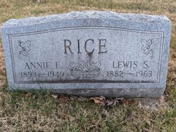
Annie Elizabeth Fultz Rice
| Birth | : | 3 Jan 1892 Maryland, USA |
| Death | : | 16 Dec 1949 Frederick County, Maryland, USA |
| Burial | : | Waiheke Lawn Cemetery, Auckland Council, New Zealand |
| Coordinate | : | -36.8015370, 175.0656180 |
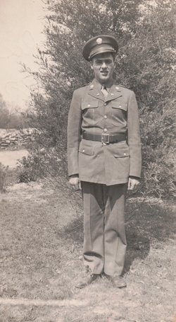
| Description | : | Mrs. Lewis S. Rice Mrs. Annie Elizabeth Rice, wife of Lewis S. Rice, of Moutaindale, died Friday evening at Frederick Memorial Hospital following an immediate illness of five weeks. A daughter of William Fultz and the late Rebecca McDevitt Fultz, she was aged 57 years, 11 months and 13 days. She was a member of the Pentecostal church, Frederick. Besides her husband and father, she is survived by the following children: Mrs. F. William Sweeney, Catoctin Furnace; Mrs. Cassell Hontz, Walkersville; Harvey Rice, Frederick; Melvin Rice, Walkersville; Elmer Rice, Clifton, NJ; Sgt. Donald Rice, Osaka, Japan; Mrs. Clifford Green, Lewistown; Austin, Glenn, and... Read More |
frequently asked questions (FAQ):
-
Where is Annie Elizabeth Fultz Rice's memorial?
Annie Elizabeth Fultz Rice's memorial is located at: Waiheke Lawn Cemetery, Auckland Council, New Zealand.
-
When did Annie Elizabeth Fultz Rice death?
Annie Elizabeth Fultz Rice death on 16 Dec 1949 in Frederick County, Maryland, USA
-
Where are the coordinates of the Annie Elizabeth Fultz Rice's memorial?
Latitude: -36.8015370
Longitude: 175.0656180
Family Members:
Parent
Spouse
Siblings

Children

Flowers:


Nearby Cemetories:
1. Waiheke Lawn Cemetery
Auckland Council, New Zealand
Coordinate: -36.8015370, 175.0656180
2. Motuihe Island Cemetery
Auckland Council, New Zealand
Coordinate: -36.8000400, 174.9363920
3. Rotoroa Island Cemetery
Auckland Council, New Zealand
Coordinate: -36.8131670, 175.2017830
4. Chamberlin Family Cemetery
Auckland, Auckland Council, New Zealand
Coordinate: -36.8627607, 175.1870226
5. Waikopua Cemetery
Whitford, Auckland Council, New Zealand
Coordinate: -36.9274400, 174.9998900
6. All Saints Cemetery
Howick, Auckland Council, New Zealand
Coordinate: -36.8954260, 174.9337600
7. Our Lady Star of the Sea Parish Cemetery
Howick, Auckland Council, New Zealand
Coordinate: -36.8932940, 174.9307940
8. Howick Cemetery
Howick, Auckland Council, New Zealand
Coordinate: -36.9040400, 174.9380500
9. St. Andrew Presbyterian Cemetery
Howick, Auckland Council, New Zealand
Coordinate: -36.8989900, 174.9201600
10. Howick Historical Village
Pakuranga, Auckland Council, New Zealand
Coordinate: -36.9067680, 174.9027080
11. Pakuranga Methodist Cemetery
Pakuranga, Auckland Council, New Zealand
Coordinate: -36.9054000, 174.8914900
12. Point England Presbyterian Cemetery
Point England, Auckland Council, New Zealand
Coordinate: -36.8823420, 174.8601550
13. Clevedon Cemetery All Souls Church
Clevedon, Auckland Council, New Zealand
Coordinate: -36.9862400, 175.0418100
14. St. Thomas Churchyard
Tamaki, Auckland Council, New Zealand
Coordinate: -36.8675590, 174.8460560
15. St Andrews Presbyterian Cemetery
Clevedon, Auckland Council, New Zealand
Coordinate: -36.9921320, 175.0371370
16. St. John’s College Graveyard
Saint Johns, Auckland Council, New Zealand
Coordinate: -36.8738169, 174.8416826
17. St. Patrick's Roman Catholic Church Cemetery
Panmure, Auckland Council, New Zealand
Coordinate: -36.9029680, 174.8564960
18. St Matthias Churchyard
Panmure, Auckland Council, New Zealand
Coordinate: -36.9053300, 174.8577200
19. Savage Memorial
Auckland, Auckland Council, New Zealand
Coordinate: -36.8462500, 174.8259300
20. Flat Bush Cemetery
East Tamaki, Auckland Council, New Zealand
Coordinate: -36.9563500, 174.9097100
21. Purewa Cemetery
Meadowbank, Auckland Council, New Zealand
Coordinate: -36.8674300, 174.8297900
22. St. John's Church Cemetery
East Tamaki, Auckland Council, New Zealand
Coordinate: -36.9522250, 174.8964540
23. St. Paul's Anglican Cemetery
East Tamaki, Auckland Council, New Zealand
Coordinate: -36.9615200, 174.9082000
24. Ōrākei (Rautara St) Urupā
Orakei, Auckland Council, New Zealand
Coordinate: -36.8610770, 174.8188960