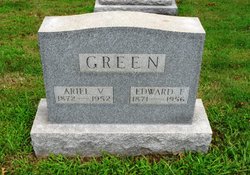
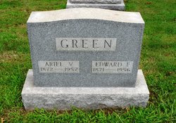
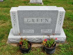
Ariel V. Harmon Green
| Birth | : | 5 Jul 1872 Perry Township, Carroll County, Ohio, USA |
| Death | : | 26 Oct 1952 Perry Township, Carroll County, Ohio, USA |
| Burial | : | Beachburg Union Cemetery, Beachburg, Renfrew County, Canada |
| Coordinate | : | 45.7300987, -76.8577194 |
frequently asked questions (FAQ):
-
Where is Ariel V. Harmon Green's memorial?
Ariel V. Harmon Green's memorial is located at: Beachburg Union Cemetery, Beachburg, Renfrew County, Canada.
-
When did Ariel V. Harmon Green death?
Ariel V. Harmon Green death on 26 Oct 1952 in Perry Township, Carroll County, Ohio, USA
-
Where are the coordinates of the Ariel V. Harmon Green's memorial?
Latitude: 45.7300987
Longitude: -76.8577194
Family Members:
Parent
Spouse
Children
Flowers:
Nearby Cemetories:
1. Beachburg Union Cemetery
Beachburg, Renfrew County, Canada
Coordinate: 45.7300987, -76.8577194
2. St. Augustines Anglican
Westmeath, Renfrew County, Canada
Coordinate: 45.7306000, -76.8597000
3. St. Augustine Anglican Cemetery
Beachburg, Renfrew County, Canada
Coordinate: 45.7306000, -76.8597300
4. Beachburg Mennonite Cemetery
Beachburg, Renfrew County, Canada
Coordinate: 45.6751052, -76.8551953
5. Beachburg Mennonite Cemetery
Cobden, Renfrew County, Canada
Coordinate: 45.6728430, -76.8527980
6. Grace United Church Cemetery
Perretton, Renfrew County, Canada
Coordinate: 45.7556200, -76.9519100
7. Howard Cemetery
Foresters Falls, Renfrew County, Canada
Coordinate: 45.6787224, -76.7817764
8. Westmeath Union Cemetery
Westmeath, Renfrew County, Canada
Coordinate: 45.8145470, -76.8879170
9. McDonald Burying Ground
Westmeath, Renfrew County, Canada
Coordinate: 45.7178231, -77.0010204
10. Our Lady Of Mount Carmel Roman Catholic Cemetery
Westmeath, Renfrew County, Canada
Coordinate: 45.8133060, -76.7716770
11. Stafford United Church Cemetery
Cobden, Renfrew County, Canada
Coordinate: 45.7120380, -77.0029160
12. Saint Patricks Anglican Cemetery
Cobden, Renfrew County, Canada
Coordinate: 45.7103750, -77.0024870
13. Cobden Cemetery
Cobden, Renfrew County, Canada
Coordinate: 45.6171200, -76.8671200
14. Saint Andrew's Presbyterian Cemetery
Kerr Line, Renfrew County, Canada
Coordinate: 45.6479200, -76.7433600
15. Greenwood United Church Cemetery
Greenwood, Renfrew County, Canada
Coordinate: 45.7751000, -77.0136800
16. Saint Pius V Cemetery
Osceola, Renfrew County, Canada
Coordinate: 45.6257000, -76.9445000
17. Pioneer Cemetery
Osceola, Renfrew County, Canada
Coordinate: 45.6231291, -76.9430902
18. Dunraven United Church Cemetery
Dunraven, Outaouais Region, Canada
Coordinate: 45.7469270, -76.6679970
19. St. Pierre's Roman Catholic Cemetery
Fort-Coulonge, Outaouais Region, Canada
Coordinate: 45.8415370, -76.7383550
20. Micksburg United Cemetery
Micksburg, Renfrew County, Canada
Coordinate: 45.6615600, -77.0353000
21. Micksburg Presbyterian Cemetery
Micksburg, Renfrew County, Canada
Coordinate: 45.6705200, -77.0462600
22. Saint Stephen Anglican Cemetery
Micksburg, Renfrew County, Canada
Coordinate: 45.6759620, -77.0546720
23. St. Joseph's Roman Catholic Cemetery
Saint-Joseph, Outaouais Region, Canada
Coordinate: 45.8525000, -76.9905841
24. Ste. Kateri Cemetery
Mansfield-et-Pontefract, Outaouais Region, Canada
Coordinate: 45.8568220, -76.7197940

