
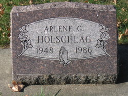
Arlene G Holschlag
| Birth | : | 19 Oct 1948 Waterloo, Black Hawk County, Iowa, USA |
| Death | : | May 1986 |
| Burial | : | Harveys Chapel Cemetery, Marmaduke, Greene County, USA |
| Coordinate | : | 36.2131004, -90.3906021 |
| Description | : | To find the grave: Cemetery is divided by a driveway into a north and a south half. Enter from Maple Street and drive west on the driveway that divides the cemetery into ‘North' and ‘South' halves until the ‘T' intersection. This grave will be ahead of you and to the left. |
frequently asked questions (FAQ):
-
Where is Arlene G Holschlag's memorial?
Arlene G Holschlag's memorial is located at: Harveys Chapel Cemetery, Marmaduke, Greene County, USA.
-
When did Arlene G Holschlag death?
Arlene G Holschlag death on May 1986 in
-
Where are the coordinates of the Arlene G Holschlag's memorial?
Latitude: 36.2131004
Longitude: -90.3906021
Family Members:
Parent

Spouse

Flowers:


Nearby Cemetories:
1. Harveys Chapel Cemetery
Marmaduke, Greene County, USA
Coordinate: 36.2131004, -90.3906021
2. Cudd Cemetery
Marmaduke, Greene County, USA
Coordinate: 36.2202988, -90.3955994
3. Starnes Cemetery
Greene County, USA
Coordinate: 36.2221080, -90.4371790
4. Pleasant Grove Cemetery
Hopewell, Greene County, USA
Coordinate: 36.2543983, -90.3630981
5. Ramers Chapel Cemetery
Marmaduke, Greene County, USA
Coordinate: 36.2344590, -90.4426930
6. Purcell Cemetery
Rector, Clay County, USA
Coordinate: 36.2602997, -90.3910980
7. Hartsoe Cemetery
Marmaduke, Greene County, USA
Coordinate: 36.1833000, -90.4372025
8. Wright Cemetery
Greene County, USA
Coordinate: 36.2075005, -90.4597015
9. Providence Cemetery
Lafe, Greene County, USA
Coordinate: 36.2011260, -90.4710830
10. Parks Cemetery
Rector, Clay County, USA
Coordinate: 36.2619934, -90.3266754
11. Mound Cemetery
Clay County, USA
Coordinate: 36.2737312, -90.3426285
12. Rock Springs Cemetery
Knob, Clay County, USA
Coordinate: 36.2785988, -90.4439011
13. Ebenezer Cemetery
Clay County, USA
Coordinate: 36.2887383, -90.3643570
14. Toelken Cemetery
Greene County, USA
Coordinate: 36.2310982, -90.4910965
15. New Liberty Cemetery
Marmaduke, Greene County, USA
Coordinate: 36.1432991, -90.4477997
16. Bethlehem Cemetery
Clay County, USA
Coordinate: 36.2872009, -90.4393997
17. Shannon Cemetery
Clay County, USA
Coordinate: 36.2982483, -90.3639374
18. Woodland Heights Cemetery
Rector, Clay County, USA
Coordinate: 36.2724991, -90.3039017
19. Scatterville Cemetery
Rector, Clay County, USA
Coordinate: 36.2813683, -90.3131104
20. New Friendship Cemetery
Paragould, Greene County, USA
Coordinate: 36.1413994, -90.4744034
21. Saint Johns Cemetery
Lafe, Greene County, USA
Coordinate: 36.2078018, -90.5132980
22. Reddick Cemetery
Greene County, USA
Coordinate: 36.1321983, -90.3158035
23. Lafe Cemetery
Lafe, Greene County, USA
Coordinate: 36.1946983, -90.5147018
24. Salem Cemetery
Rector, Clay County, USA
Coordinate: 36.3208008, -90.3818970