
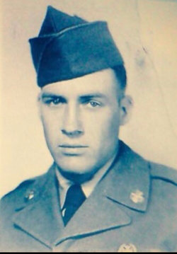

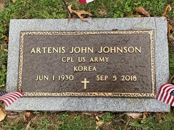
Artenis John Johnson
| Birth | : | 1 Jun 1930 West Virginia, USA |
| Death | : | 5 Sep 2018 Bridgeport, Harrison County, West Virginia, USA |
| Burial | : | Hiney Hill Cemetery, Linn, Gilmer County, USA |
| Coordinate | : | 38.9676950, -80.7405600 |
| Description | : | The Gilmer Free Press, September 8, 2018 Artenis “John” Johnson 88 years old, of Frametown, WV, passed away after a short illness on September 05, 2018 at United Hospital Center in Bridgeport, Harrison Co, West Virginia. John was born at Williams River, WV to Charlie and Olive Johnson on June 01, 1930. He married Bonnie Lee Cole on August 18, 1951 in Mavis, WV. He enlisted in the United States Army on November 20, 1951. He was in the Korean War Battalion 2nd Infantry Division until July 31, 1953 where he then spent the next seven... Read More |
frequently asked questions (FAQ):
-
Where is Artenis John Johnson's memorial?
Artenis John Johnson's memorial is located at: Hiney Hill Cemetery, Linn, Gilmer County, USA.
-
When did Artenis John Johnson death?
Artenis John Johnson death on 5 Sep 2018 in Bridgeport, Harrison County, West Virginia, USA
-
Where are the coordinates of the Artenis John Johnson's memorial?
Latitude: 38.9676950
Longitude: -80.7405600
Family Members:
Flowers:


Nearby Cemetories:
1. Hiney Hill Cemetery
Linn, Gilmer County, USA
Coordinate: 38.9676950, -80.7405600
2. Messenger Cemetery
Gilmer County, USA
Coordinate: 38.9714012, -80.7572021
3. Pickerel Cemetery
Baldwin, Gilmer County, USA
Coordinate: 38.9891200, -80.7289800
4. Conrad Cemetery
Sand Fork, Gilmer County, USA
Coordinate: 38.9364014, -80.7296982
5. Keith Cemetery
Gilmer County, USA
Coordinate: 38.9561005, -80.6986008
6. Snyder Cemetery Stewarts Creek
Glenville, Gilmer County, USA
Coordinate: 38.9577800, -80.7836100
7. McHenry Cemetery #1
Sand Fork, Gilmer County, USA
Coordinate: 38.9353310, -80.7162630
8. McHenry Cemetery
Gilmer County, USA
Coordinate: 38.9341870, -80.7130200
9. Dyer Cemetery
Gilmer County, USA
Coordinate: 38.9319000, -80.7110977
10. Varner Cemetery
Sand Fork, Gilmer County, USA
Coordinate: 38.9254709, -80.7212012
11. Rogers Cemetery
Gilmer County, USA
Coordinate: 38.9406013, -80.6936035
12. Schoonover-Dawson Cemetery
Donlan, Gilmer County, USA
Coordinate: 38.9461770, -80.6854790
13. Farnsworth Cemetery
Linn, Gilmer County, USA
Coordinate: 39.0177994, -80.7378006
14. Sand Fork Cemetery
Gilmer County, USA
Coordinate: 38.9158890, -80.7480520
15. Killingsworth Cemetery
Sand Fork, Gilmer County, USA
Coordinate: 38.9169640, -80.7249834
16. Rock Grove Cemetery
Latonia, Gilmer County, USA
Coordinate: 39.0125008, -80.7018967
17. Otterbein Cemetery
Glenville, Gilmer County, USA
Coordinate: 38.9298550, -80.7916820
18. Boilon Cemetery
Gilmer County, USA
Coordinate: 38.9519005, -80.6718979
19. Old Field Fork Cemetery
Lewis County, USA
Coordinate: 38.9827995, -80.6710968
20. Hays Cemetery
Truebada, Gilmer County, USA
Coordinate: 38.9294400, -80.8026800
21. Troy IOOF Community Cemetery
Troy, Gilmer County, USA
Coordinate: 39.0281170, -80.7679560
22. Leading Creek Baptist Church Cemetery
Alice, Gilmer County, USA
Coordinate: 38.9969000, -80.8183700
23. Blackburn Cemetery
Blackburn, Gilmer County, USA
Coordinate: 38.9235700, -80.6743200
24. Dusk Camp United Methodist Church Cemetery
Gilmer County, USA
Coordinate: 38.8961140, -80.7325440