
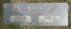
Asal Martha Hatfield Kain
| Birth | : | 10 Nov 1904 Ellensburg, Kittitas County, Washington, USA |
| Death | : | 20 May 1988 Merced County, California, USA |
| Burial | : | Goodrich Cemetery, Goodrich, Sheridan County, USA |
| Coordinate | : | 47.4716988, -100.1406021 |
| Description | : | OBIT: Asal Martha Kain, 83, lifelong Thorp area resident, died Friday at Los Banos Convalescent Care Center in Los Banos, California. She had been in poor health since suffering a massive stroke in July 1986. She was born November 10, 1904 in Thorp, a daughter of John and Evelyn (Mattox) Hatfield. She and Fred Kain were married in Ellensburg in December 1923. They farmed in the West Side District until 1950 when they retired and moved into Thorp. Her husband preceded her in death in June 1975. Mrs. Kain was a member of Thorp Community Church, the Garden Club,... Read More |
frequently asked questions (FAQ):
-
Where is Asal Martha Hatfield Kain's memorial?
Asal Martha Hatfield Kain's memorial is located at: Goodrich Cemetery, Goodrich, Sheridan County, USA.
-
When did Asal Martha Hatfield Kain death?
Asal Martha Hatfield Kain death on 20 May 1988 in Merced County, California, USA
-
Where are the coordinates of the Asal Martha Hatfield Kain's memorial?
Latitude: 47.4716988
Longitude: -100.1406021
Family Members:
Parent

Spouse

Siblings
Flowers:


Nearby Cemetories:
1. Goodrich Cemetery
Goodrich, Sheridan County, USA
Coordinate: 47.4716988, -100.1406021
2. Goodrich Seventh-Day Adventist Cemetery
Goodrich, Sheridan County, USA
Coordinate: 47.4803200, -100.1402969
3. Denhoff Catholic Cemetery
Denhoff, Sheridan County, USA
Coordinate: 47.4853247, -100.2673544
4. Denhoff Cemetery
Denhoff, Sheridan County, USA
Coordinate: 47.4839973, -100.2679291
5. Denhoff Adventist Cemetery
Sheridan County, USA
Coordinate: 47.4197006, -100.2446976
6. Saint Jacobus Lutheran Cemetery
Sheridan County, USA
Coordinate: 47.5739100, -100.1917600
7. Fairview Cemetery
Sheridan County, USA
Coordinate: 47.6032982, -100.1502991
8. First German Baptist Church Cemetery
McClusky, Sheridan County, USA
Coordinate: 47.4450684, -100.3536987
9. Pleasant Hill Cemetery
Hurdsfield, Wells County, USA
Coordinate: 47.4364014, -99.9274979
10. Hazel Grove Cemetery
Wing, Burleigh County, USA
Coordinate: 47.3150940, -100.1690700
11. Stark Mennonite Church Cemetery
Wing, Burleigh County, USA
Coordinate: 47.3153800, -100.1770700
12. Zion Cemetery
Sheridan County, USA
Coordinate: 47.6493988, -100.0755997
13. Saint Emanuel Evangelical Lutheran Cemetery
Sheridan County, USA
Coordinate: 47.6594009, -100.2247009
14. McClusky City Cemetery
McClusky, Sheridan County, USA
Coordinate: 47.4801178, -100.4373550
15. Holy Family Catholic Cemetery
McClusky, Sheridan County, USA
Coordinate: 47.4807854, -100.4375076
16. Lincoln Valley Seventh-Day Adventist Cemetery
Lincoln Valley, Sheridan County, USA
Coordinate: 47.6179466, -100.3515167
17. Lincoln Valley Baptist Cemetery
Lincoln Valley, Sheridan County, USA
Coordinate: 47.6469688, -100.2972870
18. Hope Mennonite Cemetery
Wells County, USA
Coordinate: 47.5307999, -99.8422012
19. Saint Petri Lutheran Cemetery
Harvey, Wells County, USA
Coordinate: 47.6176020, -99.9048720
20. Eigenheim Cemetery
Harvey, Wells County, USA
Coordinate: 47.6175620, -99.9046900
21. Hieb-Huft Cemetery
McClusky, Sheridan County, USA
Coordinate: 47.6029100, -100.3952700
22. Harvey Mennonite Brethren Cemetery
Harvey, Wells County, USA
Coordinate: 47.6739006, -100.0260010
23. Chaseley Cemetery
Wells County, USA
Coordinate: 47.4571991, -99.8191986
24. Lincoln Valley Lutheran Cemetery
Lincoln Valley, Sheridan County, USA
Coordinate: 47.6722527, -100.3097916