
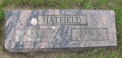
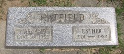
John Oliver Hatfield
| Birth | : | 1 Sep 1875 Texas, USA |
| Death | : | 7 Jul 1958 Ellensburg, Kittitas County, Washington, USA |
| Burial | : | Goodrich Cemetery, Goodrich, Sheridan County, USA |
| Coordinate | : | 47.4716988, -100.1406021 |
| Description | : | OBIT: John Oliver Hatfield, pioneer Thorp farmer and merchant, died early today at Ellensburg General Hospital at the age of 82. He suffered a heart attack in April and had been in failing health since then. He had been in the hospital since June 20. Born near Dallas, Texas, he came to this state with his parents, Mr. and Mrs. Ephraim Hatfield. The party came in a covered wagon, one of a train of 100. The journey took a year, a month, and a day. The family settled in The Dalles, where the father went into the... Read More |
frequently asked questions (FAQ):
-
Where is John Oliver Hatfield's memorial?
John Oliver Hatfield's memorial is located at: Goodrich Cemetery, Goodrich, Sheridan County, USA.
-
When did John Oliver Hatfield death?
John Oliver Hatfield death on 7 Jul 1958 in Ellensburg, Kittitas County, Washington, USA
-
Where are the coordinates of the John Oliver Hatfield's memorial?
Latitude: 47.4716988
Longitude: -100.1406021
Family Members:
Parent
Spouse

Siblings
Children
Flowers:


Nearby Cemetories:
1. Goodrich Cemetery
Goodrich, Sheridan County, USA
Coordinate: 47.4716988, -100.1406021
2. Goodrich Seventh-Day Adventist Cemetery
Goodrich, Sheridan County, USA
Coordinate: 47.4803200, -100.1402969
3. Denhoff Catholic Cemetery
Denhoff, Sheridan County, USA
Coordinate: 47.4853247, -100.2673544
4. Denhoff Cemetery
Denhoff, Sheridan County, USA
Coordinate: 47.4839973, -100.2679291
5. Denhoff Adventist Cemetery
Sheridan County, USA
Coordinate: 47.4197006, -100.2446976
6. Saint Jacobus Lutheran Cemetery
Sheridan County, USA
Coordinate: 47.5739100, -100.1917600
7. Fairview Cemetery
Sheridan County, USA
Coordinate: 47.6032982, -100.1502991
8. First German Baptist Church Cemetery
McClusky, Sheridan County, USA
Coordinate: 47.4450684, -100.3536987
9. Pleasant Hill Cemetery
Hurdsfield, Wells County, USA
Coordinate: 47.4364014, -99.9274979
10. Hazel Grove Cemetery
Wing, Burleigh County, USA
Coordinate: 47.3150940, -100.1690700
11. Stark Mennonite Church Cemetery
Wing, Burleigh County, USA
Coordinate: 47.3153800, -100.1770700
12. Zion Cemetery
Sheridan County, USA
Coordinate: 47.6493988, -100.0755997
13. Saint Emanuel Evangelical Lutheran Cemetery
Sheridan County, USA
Coordinate: 47.6594009, -100.2247009
14. McClusky City Cemetery
McClusky, Sheridan County, USA
Coordinate: 47.4801178, -100.4373550
15. Holy Family Catholic Cemetery
McClusky, Sheridan County, USA
Coordinate: 47.4807854, -100.4375076
16. Lincoln Valley Seventh-Day Adventist Cemetery
Lincoln Valley, Sheridan County, USA
Coordinate: 47.6179466, -100.3515167
17. Lincoln Valley Baptist Cemetery
Lincoln Valley, Sheridan County, USA
Coordinate: 47.6469688, -100.2972870
18. Hope Mennonite Cemetery
Wells County, USA
Coordinate: 47.5307999, -99.8422012
19. Saint Petri Lutheran Cemetery
Harvey, Wells County, USA
Coordinate: 47.6176020, -99.9048720
20. Eigenheim Cemetery
Harvey, Wells County, USA
Coordinate: 47.6175620, -99.9046900
21. Hieb-Huft Cemetery
McClusky, Sheridan County, USA
Coordinate: 47.6029100, -100.3952700
22. Harvey Mennonite Brethren Cemetery
Harvey, Wells County, USA
Coordinate: 47.6739006, -100.0260010
23. Chaseley Cemetery
Wells County, USA
Coordinate: 47.4571991, -99.8191986
24. Lincoln Valley Lutheran Cemetery
Lincoln Valley, Sheridan County, USA
Coordinate: 47.6722527, -100.3097916