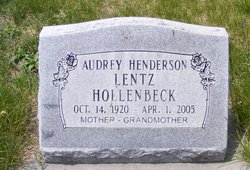
Audrey Ion Henderson Hollenbeck
| Birth | : | 14 Oct 1920 Ainsworth, Brown County, Nebraska, USA |
| Death | : | 1 Apr 2005 Aurora, Hamilton County, Nebraska, USA |
| Burial | : | Great Bowden Cemetery, Great Bowden, Harborough District, England |
| Coordinate | : | 52.4916800, -0.8995200 |
| Description | : | Audrey Ion Hollenbeck, the daughter of William and Emma (Fernau) Henderson, was born in Ainsworth, Nebraska on October 14, 1920 and died in Aurora, Nebraska on April 1, 2005, at the age of 84. She grew up in the Long Pine and Ainsworth area. Audrey attended country school through the 8th grade. Audrey was united in marriage to Calvin Lentz and they had three sons. They raised their children in the Ainsworth and Long Pine area and then moved to the Rushville area due to his job with the railroad. She was married to Doyle Hollenbeck and... Read More |
frequently asked questions (FAQ):
-
Where is Audrey Ion Henderson Hollenbeck's memorial?
Audrey Ion Henderson Hollenbeck's memorial is located at: Great Bowden Cemetery, Great Bowden, Harborough District, England.
-
When did Audrey Ion Henderson Hollenbeck death?
Audrey Ion Henderson Hollenbeck death on 1 Apr 2005 in Aurora, Hamilton County, Nebraska, USA
-
Where are the coordinates of the Audrey Ion Henderson Hollenbeck's memorial?
Latitude: 52.4916800
Longitude: -0.8995200
Family Members:
Parent
Children
Flowers:
Nearby Cemetories:
1. Great Bowden Cemetery
Great Bowden, Harborough District, England
Coordinate: 52.4916800, -0.8995200
2. St. Mary in Arden Churchyard
Market Harborough, Harborough District, England
Coordinate: 52.4804240, -0.9110140
3. St. Nicholas Churchyard
Little Bowden, Harborough District, England
Coordinate: 52.4754180, -0.9114670
4. St Dionysius Parish Church
Market Harborough, Harborough District, England
Coordinate: 52.4785850, -0.9213720
5. All Saints Churchyard
Dingley, Kettering Borough, England
Coordinate: 52.4817700, -0.8682200
6. Market Harborough Cemetery
Market Harborough, Harborough District, England
Coordinate: 52.4684000, -0.9132760
7. Thorpe Langton, St Leonard's Churchyard
Thorpe Langton, Harborough District, England
Coordinate: 52.5247101, -0.9104123
8. St Andrew's Churchyard
Welham, Harborough District, England
Coordinate: 52.5246240, -0.8733420
9. St. Mary's Churchyard
Brampton Ash, Kettering Borough, England
Coordinate: 52.4796000, -0.8402000
10. St Mary the Virgin Churchyard
Brampton, Kettering Borough, England
Coordinate: 52.4797580, -0.8400370
11. All Saints Churchyard
Braybrooke, Kettering Borough, England
Coordinate: 52.4538160, -0.8764390
12. All Saints Churchyard
Lubenham, Harborough District, England
Coordinate: 52.4770020, -0.9631870
13. Saint Helen's Churchyard
Great Oxendon, Daventry District, England
Coordinate: 52.4484500, -0.9191000
14. St Andrew Churchyard
Foxton, Harborough District, England
Coordinate: 52.5011100, -0.9716680
15. Foxton Cemetery
Foxton, Harborough District, England
Coordinate: 52.4998900, -0.9734000
16. Saint John the Baptist Churchyard
East Farndon, Daventry District, England
Coordinate: 52.4562100, -0.9472400
17. St. Peter's Churchyard
Church Langton, Harborough District, England
Coordinate: 52.5335260, -0.9337150
18. St Botolph Churchyard
Stoke Albany, Kettering Borough, England
Coordinate: 52.4865500, -0.8151720
19. St. Nicholas' Churchyard
Marston Trussell, Daventry District, England
Coordinate: 52.4669200, -0.9804650
20. All Saints Churchyard
Wilbarston, Kettering Borough, England
Coordinate: 52.4870920, -0.8056930
21. All Saints Churchyard
Slawston, Harborough District, England
Coordinate: 52.5428240, -0.8500170
22. St. John the Baptist Churchyard
Goadby, Harborough District, England
Coordinate: 52.5497940, -0.8783680
23. St Giles Churchyard
Medbourne, Harborough District, England
Coordinate: 52.5296410, -0.8226870
24. St. Andrews Churchyard
Tur Langton, Harborough District, England
Coordinate: 52.5442400, -0.9493500


