

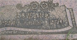
August Edward Mattson
| Birth | : | 23 Aug 1899 Centerville, Klickitat County, Washington, USA |
| Death | : | 12 May 1970 Goldendale, Klickitat County, Washington, USA |
| Burial | : | Alta Mesa Memorial Park, Palo Alto, Santa Clara County, USA |
| Coordinate | : | 37.3990200, -122.1288300 |
| Plot | : | Block Section G Lot 5.00 Space 4 |
| Description | : | OBIT: The Goldendale Sentinel, Goldendale, WA., May 14, 1970, page 1 ED MATTSON SERVICES TO BE HELD SATURDAY Edward Mattson, lifelong resident of Klickitat county, passed away suddenly at his home in Goldendale May 12, 1970. He had just climbed into his automobile to back out of the driveway Tuesday morning when he apparently had a heart attack and was gone instantly. Funeral services will be held Saturday, May 16, 2 p.m. at the Knosher Funeral Home with the Rev. Don E. McCauley officiating. Surviving are his wife Esther and two daughters, Denise Morris and Beverly Wheelhouse of Roosevelt. The family suggest in... Read More |
frequently asked questions (FAQ):
-
Where is August Edward Mattson's memorial?
August Edward Mattson's memorial is located at: Alta Mesa Memorial Park, Palo Alto, Santa Clara County, USA.
-
When did August Edward Mattson death?
August Edward Mattson death on 12 May 1970 in Goldendale, Klickitat County, Washington, USA
-
Where are the coordinates of the August Edward Mattson's memorial?
Latitude: 37.3990200
Longitude: -122.1288300
Family Members:
Spouse
Flowers:


Nearby Cemetories:
1. Alta Mesa Memorial Park
Palo Alto, Santa Clara County, USA
Coordinate: 37.3990200, -122.1288300
2. Saint Marks Episcopal Church All Souls Garden
Palo Alto, Santa Clara County, USA
Coordinate: 37.4318900, -122.1299000
3. Mountain View Cemetery
Mountain View, Santa Clara County, USA
Coordinate: 37.3894600, -122.0834300
4. Christ Episcopal Church Columbarium
Los Altos, Santa Clara County, USA
Coordinate: 37.3642210, -122.1044590
5. Mountain View Buddhist Church
Mountain View, Santa Clara County, USA
Coordinate: 37.4020680, -122.0774160
6. Saint Timothy's Episcopal Church Columbarium
Mountain View, Santa Clara County, USA
Coordinate: 37.3725650, -122.0782480
7. Stanford Family Mausoleum
Palo Alto, Santa Clara County, USA
Coordinate: 37.4364929, -122.1698990
8. All Saints Episcopal Church Memorial Garden
Palo Alto, Santa Clara County, USA
Coordinate: 37.4466933, -122.1592525
9. First United Methodist Church Memorial Garden
Palo Alto, Santa Clara County, USA
Coordinate: 37.4493870, -122.1568630
10. Holy Cross Catholic Cemetery
Menlo Park, San Mateo County, USA
Coordinate: 37.4350420, -122.1978540
11. Saint Bedes Episcopal Church Cemetery
Menlo Park, San Mateo County, USA
Coordinate: 37.4218750, -122.2075210
12. Saint Patricks Seminary Chapel Crypt
Menlo Park, San Mateo County, USA
Coordinate: 37.4595050, -122.1680330
13. Trinity Episcopal Church Memorial Garden
Menlo Park, San Mateo County, USA
Coordinate: 37.4562300, -122.1789300
14. Saint Thomas Episcopal Church Columbarium
Sunnyvale, Santa Clara County, USA
Coordinate: 37.3773110, -122.0432030
15. Corpus Christi Monastery
Menlo Park, San Mateo County, USA
Coordinate: 37.4589200, -122.1801900
16. Oakwood Community Cemetery
Atherton, San Mateo County, USA
Coordinate: 37.4503120, -122.1956310
17. Dennis Martin Cemetery
San Mateo County, USA
Coordinate: 37.4203440, -122.2181370
18. Maryknoll Fathers Seminary Cemetery
Los Altos, Santa Clara County, USA
Coordinate: 37.3340500, -122.0825500
19. Saint Luke Lutheran Church Columbarium
Sunnyvale, Santa Clara County, USA
Coordinate: 37.3453400, -122.0560300
20. Gate Of Heaven Catholic Cemetery
Los Altos, Santa Clara County, USA
Coordinate: 37.3289030, -122.0802930
21. Christ Episcopal Church Churchyard Columbarium
Portola Valley, San Mateo County, USA
Coordinate: 37.3821670, -122.2304160
22. Presbyterian Church of Sunnyvale Memorial Gardens
Sunnyvale, Santa Clara County, USA
Coordinate: 37.3520012, -122.0422974
23. Union Cemetery
Redwood City, San Mateo County, USA
Coordinate: 37.4732700, -122.2231360
24. Gorilla Foundation Sanctuary
Woodside, San Mateo County, USA
Coordinate: 37.3750160, -122.2604360