
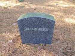
Bathsheba Robie Lane
| Birth | : | 2 Aug 1696 Hampton, Rockingham County, New Hampshire, USA |
| Death | : | 13 Apr 1765 Hampton, Rockingham County, New Hampshire, USA |
| Burial | : | Point Clare Cemetery, Point Clare, Central Coast Council, Australia |
| Coordinate | : | -33.4344800, 151.3128600 |
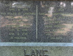
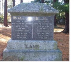
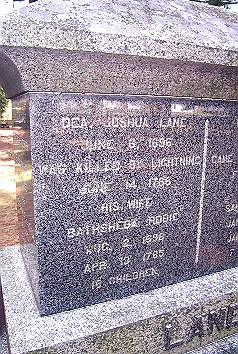
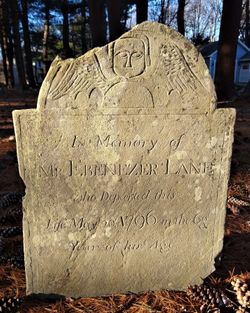
| Inscription | : | Dea. Joshua Lane | June 6, 1696 | Was Killed By Lightning | June 14, 1766 | His Wife | Bathsheba Robie | Aug. 2, 1696 | Apr. 13, 1765 | 16 Children |
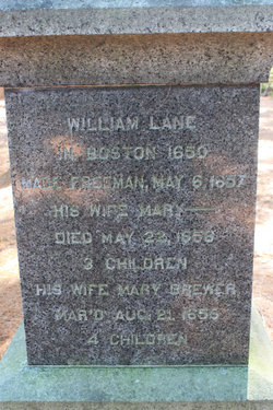
| Description | : | Bathsheba Robie is the daughter of Samuel and Mary (Page) Robie of Hampton, Rockingham county, New Hampshire. Joshua Lane and Bathsheba Robie were married December 24, 1717 in Hampton, Rockingham county, New Hampshire. |
frequently asked questions (FAQ):
-
Where is Bathsheba Robie Lane's memorial?
Bathsheba Robie Lane's memorial is located at: Point Clare Cemetery, Point Clare, Central Coast Council, Australia.
-
When did Bathsheba Robie Lane death?
Bathsheba Robie Lane death on 13 Apr 1765 in Hampton, Rockingham County, New Hampshire, USA
-
Where are the coordinates of the Bathsheba Robie Lane's memorial?
Latitude: -33.4344800
Longitude: 151.3128600
Family Members:
Parent

Spouse
Siblings
Children
Flowers:


Nearby Cemetories:
1. Point Clare Cemetery
Point Clare, Central Coast Council, Australia
Coordinate: -33.4344800, 151.3128600
2. Point Frederick Pioneer Cemetery
Point Frederick, Central Coast Council, Australia
Coordinate: -33.4498830, 151.3417900
3. Bradys Gully Cemetery
Gosford, Central Coast Council, Australia
Coordinate: -33.4168700, 151.3492720
4. Helys Grave
Wyoming, Central Coast Council, Australia
Coordinate: -33.4031120, 151.3505420
5. Veteran Hall
Saratoga, Central Coast Council, Australia
Coordinate: -33.4786400, 151.3452750
6. Greenway Chapel & Memorial Gardens
Kincumber, Central Coast Council, Australia
Coordinate: -33.4639900, 151.3734500
7. Kincumber South Cemetery
Kincumber South, Central Coast Council, Australia
Coordinate: -33.4880610, 151.3759430
8. St Paul's Anglican Church Cemetery
Kincumber, Central Coast Council, Australia
Coordinate: -33.4697950, 151.3952220
9. Lisarow Cemetery
Lisarow, Central Coast Council, Australia
Coordinate: -33.3761970, 151.3747470
10. Maloney Gravesite
Glenworth Valley, Central Coast Council, Australia
Coordinate: -33.4039645, 151.1957958
11. Palmdale Lawn Cemetery & Memorial Park
Palmdale, Central Coast Council, Australia
Coordinate: -33.3315580, 151.3750700
12. Wamberal Cemetery
Wamberal, Central Coast Council, Australia
Coordinate: -33.4169640, 151.4503560
13. Holy Trinity Church Cemetery
Spencer, Central Coast Council, Australia
Coordinate: -33.4293910, 151.1639380
14. Ronkana Cemetery
Fountaindale, Central Coast Council, Australia
Coordinate: -33.3334600, 151.4005200
15. Frances Peat Lone Grave
Mooney Mooney, Central Coast Council, Australia
Coordinate: -33.5333171, 151.1989208
16. Barrenjoey Head
Palm Beach, Northern Beaches Council, Australia
Coordinate: -33.5802716, 151.3300583
17. Brooklyn General Cemetery
Brooklyn, Hornsby Shire, Australia
Coordinate: -33.5471710, 151.1990020
18. Greengrove Saint Peters Cemetery
Greengrove, Central Coast Council, Australia
Coordinate: -33.3803020, 151.1400300
19. Bar Island Cemetery
Hornsby Shire, Australia
Coordinate: -33.5262140, 151.1528610
20. Jilliby Cemetery
Jilliby, Central Coast Council, Australia
Coordinate: -33.2607610, 151.3974120
21. Upper Mangrove Saint Thomas Anglican
Upper Mangrove Creek, Central Coast Council, Australia
Coordinate: -33.3108330, 151.1296840
22. Avalon Anglican Columbarium
Avalon, Northern Beaches Council, Australia
Coordinate: -33.6333540, 151.3304900
23. Yarramalong Cemetery
Yarramalong, Central Coast Council, Australia
Coordinate: -33.2263180, 151.2881020
24. Church Point Historic Cemetery
Church Point, Northern Beaches Council, Australia
Coordinate: -33.6450120, 151.2841090