
| Birth | : | 8 Jul 1724 Hampton, Rockingham County, New Hampshire, USA |
| Death | : | 22 Jun 1729 Hampton, Rockingham County, New Hampshire, USA |
| Burial | : | Point Clare Cemetery, Point Clare, Central Coast Council, Australia |
| Coordinate | : | -33.4344800, 151.3128600 |
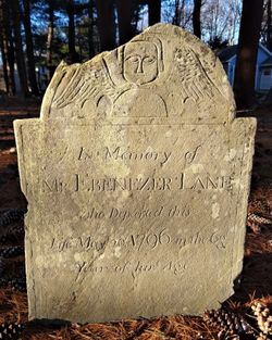
| Inscription | : | Josiah 1724-1729 |
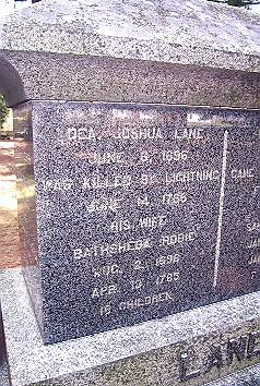
| Description | : | Josiah Lane is the son of Joshua and Bathsheba (Robie) Lane of Hampton, Rockongham county, New Hampshire. |
frequently asked questions (FAQ):
-
Where is Josiah Lane's memorial?
Josiah Lane's memorial is located at: Point Clare Cemetery, Point Clare, Central Coast Council, Australia.
-
When did Josiah Lane death?
Josiah Lane death on 22 Jun 1729 in Hampton, Rockingham County, New Hampshire, USA
-
Where are the coordinates of the Josiah Lane's memorial?
Latitude: -33.4344800
Longitude: 151.3128600
Family Members:
Parent
Siblings

Flowers:


Nearby Cemetories:
1. Point Clare Cemetery
Point Clare, Central Coast Council, Australia
Coordinate: -33.4344800, 151.3128600
2. Point Frederick Pioneer Cemetery
Point Frederick, Central Coast Council, Australia
Coordinate: -33.4498830, 151.3417900
3. Bradys Gully Cemetery
Gosford, Central Coast Council, Australia
Coordinate: -33.4168700, 151.3492720
4. Helys Grave
Wyoming, Central Coast Council, Australia
Coordinate: -33.4031120, 151.3505420
5. Veteran Hall
Saratoga, Central Coast Council, Australia
Coordinate: -33.4786400, 151.3452750
6. Greenway Chapel & Memorial Gardens
Kincumber, Central Coast Council, Australia
Coordinate: -33.4639900, 151.3734500
7. Kincumber South Cemetery
Kincumber South, Central Coast Council, Australia
Coordinate: -33.4880610, 151.3759430
8. St Paul's Anglican Church Cemetery
Kincumber, Central Coast Council, Australia
Coordinate: -33.4697950, 151.3952220
9. Lisarow Cemetery
Lisarow, Central Coast Council, Australia
Coordinate: -33.3761970, 151.3747470
10. Maloney Gravesite
Glenworth Valley, Central Coast Council, Australia
Coordinate: -33.4039645, 151.1957958
11. Palmdale Lawn Cemetery & Memorial Park
Palmdale, Central Coast Council, Australia
Coordinate: -33.3315580, 151.3750700
12. Wamberal Cemetery
Wamberal, Central Coast Council, Australia
Coordinate: -33.4169640, 151.4503560
13. Holy Trinity Church Cemetery
Spencer, Central Coast Council, Australia
Coordinate: -33.4293910, 151.1639380
14. Ronkana Cemetery
Fountaindale, Central Coast Council, Australia
Coordinate: -33.3334600, 151.4005200
15. Frances Peat Lone Grave
Mooney Mooney, Central Coast Council, Australia
Coordinate: -33.5333171, 151.1989208
16. Barrenjoey Head
Palm Beach, Northern Beaches Council, Australia
Coordinate: -33.5802716, 151.3300583
17. Brooklyn General Cemetery
Brooklyn, Hornsby Shire, Australia
Coordinate: -33.5471710, 151.1990020
18. Greengrove Saint Peters Cemetery
Greengrove, Central Coast Council, Australia
Coordinate: -33.3803020, 151.1400300
19. Bar Island Cemetery
Hornsby Shire, Australia
Coordinate: -33.5262140, 151.1528610
20. Jilliby Cemetery
Jilliby, Central Coast Council, Australia
Coordinate: -33.2607610, 151.3974120
21. Upper Mangrove Saint Thomas Anglican
Upper Mangrove Creek, Central Coast Council, Australia
Coordinate: -33.3108330, 151.1296840
22. Avalon Anglican Columbarium
Avalon, Northern Beaches Council, Australia
Coordinate: -33.6333540, 151.3304900
23. Yarramalong Cemetery
Yarramalong, Central Coast Council, Australia
Coordinate: -33.2263180, 151.2881020
24. Church Point Historic Cemetery
Church Point, Northern Beaches Council, Australia
Coordinate: -33.6450120, 151.2841090