
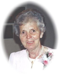
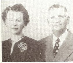
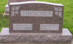
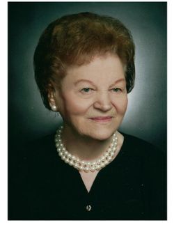
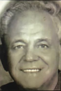
Bernadette Schmelzer Stroschein
| Birth | : | 6 Nov 1924 Guttenberg, Clayton County, Iowa, USA |
| Death | : | 8 Nov 2011 Guttenberg, Clayton County, Iowa, USA |
| Burial | : | Saint Joseph Cemetery, Garnavillo, Clayton County, USA |
| Coordinate | : | 42.8628006, -91.2502975 |
| Description | : | Daughter of Albert & Alvina Felder Schmelzer Bernadette (Schmelzer) Stroschein, age 87, of Guttenberg, formerly of Garnavillo, IA, died Tuesday, November 8, 2011, at the Guttenberg Care Center. She was born the daughter of Albert and Alvina (Felder) Schmelzer on November 6, 1924 on the family farm in rural Guttenberg. Bernadette married the love of her life, Lawrence Stroschein, April 4, 1945. They raised a family of ten children on a dairy farm near Garnavillo, Iowa. Bernadette loved to cook for her family and enjoyed all the duties of a farm wife/mother. She enjoyed taking care of the farm animals, cleaning a big... Read More |
frequently asked questions (FAQ):
-
Where is Bernadette Schmelzer Stroschein's memorial?
Bernadette Schmelzer Stroschein's memorial is located at: Saint Joseph Cemetery, Garnavillo, Clayton County, USA.
-
When did Bernadette Schmelzer Stroschein death?
Bernadette Schmelzer Stroschein death on 8 Nov 2011 in Guttenberg, Clayton County, Iowa, USA
-
Where are the coordinates of the Bernadette Schmelzer Stroschein's memorial?
Latitude: 42.8628006
Longitude: -91.2502975
Family Members:
Parent

Spouse
Siblings

Flowers:


Nearby Cemetories:
1. Saint Joseph Cemetery
Garnavillo, Clayton County, USA
Coordinate: 42.8628006, -91.2502975
2. Garnavillo Community Cemetery
Garnavillo, Clayton County, USA
Coordinate: 42.8656000, -91.2422100
3. Garnavillo Cemetery
Garnavillo, Clayton County, USA
Coordinate: 42.8660300, -91.2390100
4. McClelland Cemetery
Garnavillo, Clayton County, USA
Coordinate: 42.8249879, -91.2084641
5. Clayton Center Cemetery
Clayton Center, Clayton County, USA
Coordinate: 42.8841705, -91.3225021
6. Zion Lutheran Cemetery
Clayton Center, Clayton County, USA
Coordinate: 42.8841705, -91.3249969
7. Pioneer Rock Cemetery
Ceres, Clayton County, USA
Coordinate: 42.8230591, -91.1863937
8. Clayton Cemetery
Clayton, Clayton County, USA
Coordinate: 42.9043999, -91.1641998
9. Saint Michael Cemetery
Clayton County, USA
Coordinate: 42.8055992, -91.1802979
10. County Home Cemetery
Clayton Center, Clayton County, USA
Coordinate: 42.8916702, -91.3499985
11. Tangeman Family Cemetery
Garnavillo, Clayton County, USA
Coordinate: 42.8580000, -91.1420000
12. Krumm Cemetery
Garber, Clayton County, USA
Coordinate: 42.7913760, -91.3023559
13. Colony Catholic Cemetery (Defunct)
Read Township, Clayton County, USA
Coordinate: 42.8830000, -91.3580000
14. Borcherding Cemetery
Jefferson Township, Clayton County, USA
Coordinate: 42.8182983, -91.1414032
15. National Cemetery
National, Clayton County, USA
Coordinate: 42.9536018, -91.2902985
16. Meenan Cemetery
Communia, Clayton County, USA
Coordinate: 42.7999862, -91.3584693
17. Storck Cemetery
Guttenberg, Clayton County, USA
Coordinate: 42.7694335, -91.1834638
18. Saint Paula Cemetery
Osterdock, Clayton County, USA
Coordinate: 42.7635994, -91.1992035
19. Old Garber Cemetery
Garber, Clayton County, USA
Coordinate: 42.7560005, -91.2580032
20. Elkader Cemetery
Elkader, Clayton County, USA
Coordinate: 42.8541718, -91.4000015
21. Hartman Cemetery
Cox Creek Township, Clayton County, USA
Coordinate: 42.8155360, -91.3880840
22. Harford Cemetery
Wyalusing, Grant County, USA
Coordinate: 42.9401000, -91.1401800
23. Saint Josephs Cemetery
Elkader, Clayton County, USA
Coordinate: 42.8488998, -91.4021988
24. Communia Cemetery
Volga Township, Clayton County, USA
Coordinate: 42.7868996, -91.3630981