
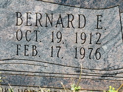
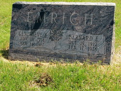
Bernard E “Bud” Emrich
| Birth | : | 19 Oct 1912 Longford, Clay County, Kansas, USA |
| Death | : | 17 Feb 1976 Abilene, Dickinson County, Kansas, USA |
| Burial | : | Rose Meron Cemetery, Oak Hill, Clay County, USA |
| Coordinate | : | 39.2194700, -97.3338900 |
| Description | : | BERNARD EMRICH Bernard (Bud) Emrich, 68, 321 S. 11th Ave., Salina, died Tuesday at the Abilene Memorial Hospital after suffering a heart attack. He was born Oct. 19, 1912 at Longford. He was a member of Masonic Lodge of Salina, the Scottish Rite and Isis Temple of Shrine. Survivors are his wife, Mrs. Genevieve Emrich, three children, Hugh Emrich, Manhattan, Mrs. Virginia McIntire, El Dorado and Mrs. Susan Minick, Talmage; 10 grandchildren; a brother, Hugh Emrich of Longford. Funeral services will be held Thursday at 2 p.m. in the First Baptist Church at Salina, with the Rev. Herman Van Arsdale officiating. Interment will... Read More |
frequently asked questions (FAQ):
-
Where is Bernard E “Bud” Emrich's memorial?
Bernard E “Bud” Emrich's memorial is located at: Rose Meron Cemetery, Oak Hill, Clay County, USA.
-
When did Bernard E “Bud” Emrich death?
Bernard E “Bud” Emrich death on 17 Feb 1976 in Abilene, Dickinson County, Kansas, USA
-
Where are the coordinates of the Bernard E “Bud” Emrich's memorial?
Latitude: 39.2194700
Longitude: -97.3338900
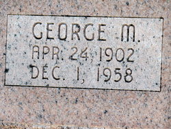
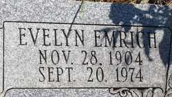
Family Members:
Parent

Spouse
Siblings
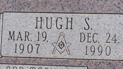
Children
Flowers:


Nearby Cemetories:
1. Rose Meron Cemetery
Oak Hill, Clay County, USA
Coordinate: 39.2194700, -97.3338900
2. Pleasant Valley Cemetery
Oak Hill, Clay County, USA
Coordinate: 39.2468987, -97.2889023
3. Wesleyan Cemetery
Oak Hill, Clay County, USA
Coordinate: 39.2268982, -97.2572021
4. Mount Liberty Church Cemetery
Ottawa County, USA
Coordinate: 39.2489400, -97.4356200
5. Swartwood Cemetery
Longford, Clay County, USA
Coordinate: 39.1323200, -97.3431500
6. Shields Cemetery
Clay County, USA
Coordinate: 39.3208008, -97.3507996
7. Table Mound Cemetery
Idana, Clay County, USA
Coordinate: 39.3141300, -97.2792300
8. Keystone Cemetery
Manchester, Dickinson County, USA
Coordinate: 39.1185989, -97.2917023
9. Hebron Cemetery
Clay County, USA
Coordinate: 39.3213800, -97.2601400
10. Vine Creek Cemetery
Ottawa County, USA
Coordinate: 39.1194000, -97.4180984
11. Athelstane Cemetery
Athelstane Township, Clay County, USA
Coordinate: 39.1768990, -97.1753006
12. Pleasant Ridge Cemetery
Clay County, USA
Coordinate: 39.2789001, -97.1841965
13. Miltonvale Cemetery
Miltonvale, Cloud County, USA
Coordinate: 39.3358002, -97.4447021
14. White Cloud Cemetery
Manchester, Dickinson County, USA
Coordinate: 39.0744019, -97.3525009
15. Idana Cemetery
Idana, Clay County, USA
Coordinate: 39.3574500, -97.2693300
16. Zion Lutheran Cemetery
Clay County, USA
Coordinate: 39.2928009, -97.1557999
17. Mizpah Cemetery
Clay County, USA
Coordinate: 39.2057800, -97.1238500
18. Smith Grave
Miltonvale, Cloud County, USA
Coordinate: 39.3645300, -97.4308700
19. Fairview Cemetery
Lamar, Ottawa County, USA
Coordinate: 39.2928009, -97.5299988
20. Ackley Cemetery
Ottawa County, USA
Coordinate: 39.0893160, -97.4797040
21. Greenridge Cemetery
Dickinson County, USA
Coordinate: 39.1199989, -97.1433029
22. Henry Cemetery
Buckeye, Dickinson County, USA
Coordinate: 39.0828018, -97.1857986
23. Prairiedale Cemetery
Talmage, Dickinson County, USA
Coordinate: 39.0471992, -97.2652969
24. Republican City Cemetery
Clay Center, Clay County, USA
Coordinate: 39.3431015, -97.1628036