
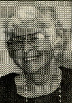

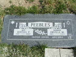
Bertha Pauline Williams Peebles
| Birth | : | 8 Sep 1919 Council Grove, Morris County, Kansas, USA |
| Death | : | 30 Jun 2007 Brewster, Okanogan County, Washington, USA |
| Burial | : | Riverview Cemetery, Chelan, Chelan County, USA |
| Coordinate | : | 47.8335991, -119.9944000 |
| Plot | : | Row 25 Alley 2 Block 4 Lot 1 |
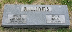
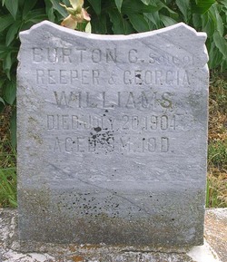
| Description | : | Bertha P. Peebles of Chelan – posted July 3, 2007 Bertha P. Peebles, 87, a resident of Chelan since 1945, died Saturday, June 30, 2007, at Harmony House Health Care Center in Brewster. She was born September 8, 1919, in Council Grove, KS, the daughter of Reaper and Georgia (Coates) Williams. Bertha attended schools there, and on September 23, 1937, she was married to Orville M. Peebles at Cottonwood, KS. They moved to Pasco and later to Pateros in 1942. In 1945, the family moved to Chelan. She and her husband were active in the... Read More |
frequently asked questions (FAQ):
-
Where is Bertha Pauline Williams Peebles's memorial?
Bertha Pauline Williams Peebles's memorial is located at: Riverview Cemetery, Chelan, Chelan County, USA.
-
When did Bertha Pauline Williams Peebles death?
Bertha Pauline Williams Peebles death on 30 Jun 2007 in Brewster, Okanogan County, Washington, USA
-
Where are the coordinates of the Bertha Pauline Williams Peebles's memorial?
Latitude: 47.8335991
Longitude: -119.9944000
Family Members:
Parent

Spouse
Siblings

Flowers:


Nearby Cemetories:
1. Riverview Cemetery
Chelan, Chelan County, USA
Coordinate: 47.8335991, -119.9944000
2. Mount Olivet Cemetery
Chelan, Chelan County, USA
Coordinate: 47.8451000, -119.9946000
3. Saint Andrews Episcopal Church
Chelan, Chelan County, USA
Coordinate: 47.8397460, -120.0183780
4. Chelan Fraternal Cemetery
Chelan, Chelan County, USA
Coordinate: 47.8502998, -120.0081024
5. Ballard Family Cemetery
Stayman, Chelan County, USA
Coordinate: 47.7811100, -120.1133300
6. Fletcher Cemetery
Douglas County, USA
Coordinate: 47.7430992, -119.9403000
7. Manson Indian Cemetery
Manson, Chelan County, USA
Coordinate: 47.8800000, -120.1300000
8. Brays Landing Cemetery
Douglas County, USA
Coordinate: 47.7364120, -120.1704660
9. Kummer Cemetery
Waterville, Douglas County, USA
Coordinate: 47.6559000, -120.0332000
10. Waterville Cemetery
Waterville, Douglas County, USA
Coordinate: 47.6418500, -120.0685940
11. Gate of Heaven Catholic Cemetery
Waterville, Douglas County, USA
Coordinate: 47.6382100, -120.0671690
12. Packwood Memorial Cemetery
Dyer, Douglas County, USA
Coordinate: 48.0118305, -119.8178880
13. Douglas Lutheran Cemetery
Douglas County, USA
Coordinate: 47.6189003, -119.9614029
14. Dick Family Cemetery
Okanogan County, USA
Coordinate: 48.0502700, -119.9241700
15. Miller Family Cemetery
Okanogan County, USA
Coordinate: 48.0530300, -119.9288000
16. Pateros Cemetery
Pateros, Okanogan County, USA
Coordinate: 48.0516600, -119.9097300
17. Badger Mountain View Cemetery
Douglas County, USA
Coordinate: 47.6088000, -120.0476000
18. Mansfield Cemetery
Mansfield, Douglas County, USA
Coordinate: 47.8088880, -119.6508330
19. Orondo Community Cemetery
Orondo, Douglas County, USA
Coordinate: 47.6486015, -120.2136002
20. Happy Home Cemetery
Farmer, Douglas County, USA
Coordinate: 47.6268997, -119.8125000
21. Buckingham Cemetery
Douglas County, USA
Coordinate: 47.8669014, -119.6286011
22. Entiat Cemetery
Entiat, Chelan County, USA
Coordinate: 47.6755981, -120.3043976
23. Jameson Cemetery
Douglas County, USA
Coordinate: 47.6857986, -119.6624985
24. Bridgeport Cemetery
Bridgeport, Douglas County, USA
Coordinate: 48.0050000, -119.6738800