
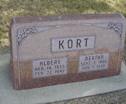
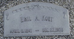
Bertha Yaeger Kort
| Birth | : | 7 Sep 1862 Brandenburg, Germany |
| Death | : | 1 Nov 1944 Blue Hill, Webster County, Nebraska, USA |
| Burial | : | St. James' Churchyard, Cameley, Bath and North East Somerset Unitary Authority, England |
| Coordinate | : | 51.3158560, -2.5606190 |
| Plot | : | SW section Lot 6 |
| Description | : | d/Herman & Ernistene (Redenz) Yaeger August Kort August Kort came from Brandenburg, West Preussen, Germany to Nebraska in March 1872 and homesteaded a quarter section of land three miles north of Blue Hill in Adams county. His first wife, nee Augusta Meyer, died in 1900, and he was married again in 1905 to Miss Wilhelmina Waechter, who died in 1927. The six children of the family all live near Blue Hill. They are Herman, Walter, Adolph and Herbert who operates farms; Mrs William Amanda Brockstadter of Kenesaw, and Oscar A. Kort of Blue Hill. Mr Kort helped... Read More |
frequently asked questions (FAQ):
-
Where is Bertha Yaeger Kort's memorial?
Bertha Yaeger Kort's memorial is located at: St. James' Churchyard, Cameley, Bath and North East Somerset Unitary Authority, England.
-
When did Bertha Yaeger Kort death?
Bertha Yaeger Kort death on 1 Nov 1944 in Blue Hill, Webster County, Nebraska, USA
-
Where are the coordinates of the Bertha Yaeger Kort's memorial?
Latitude: 51.3158560
Longitude: -2.5606190
Family Members:
Spouse

Children
Flowers:


Nearby Cemetories:
1. St. James' Churchyard
Cameley, Bath and North East Somerset Unitary Authority, England
Coordinate: 51.3158560, -2.5606190
2. St Margarets Churchyard
Hinton Blewett, Bath and North East Somerset Unitary Authority, England
Coordinate: 51.3104000, -2.5834000
3. Saint Augustine of Hippo
Clutton, Bath and North East Somerset Unitary Authority, England
Coordinate: 51.3281990, -2.5430220
4. St Nicholas & the Blessed Virgin Mary
Stowey Sutton, Bath and North East Somerset Unitary Authority, England
Coordinate: 51.3329190, -2.5764850
5. St. John the Baptist Churchyard
Farrington Gurney, Bath and North East Somerset Unitary Authority, England
Coordinate: 51.2993710, -2.5248000
6. Bishop's Sutton Holy Trinity Churchyard
Bath and North East Somerset Unitary Authority, England
Coordinate: 51.3341900, -2.5958300
7. Saint Mary the Virgin Churchyard
Litton, Mendip District, England
Coordinate: 51.2899860, -2.5838440
8. Holy Trinity Churchyard
High Littleton, Bath and North East Somerset Unitary Authority, England
Coordinate: 51.3195810, -2.5115860
9. Church of the Holy Trinity
Paulton, Bath and North East Somerset Unitary Authority, England
Coordinate: 51.3074740, -2.5033500
10. Saint Mary the Virgin Church
Ston Easton, Mendip District, England
Coordinate: 51.2789610, -2.5407720
11. Paulton Cemetery
Paulton, Bath and North East Somerset Unitary Authority, England
Coordinate: 51.3095671, -2.4988841
12. St Mary The Virgin Churchyard
Ston Easton, Mendip District, England
Coordinate: 51.2788400, -2.5404390
13. Harptree Cemetery
East Harptree, Bath and North East Somerset Unitary Authority, England
Coordinate: 51.3056390, -2.6238890
14. St Mary Magdalene Churchyard
Chewton Mendip, Mendip District, England
Coordinate: 51.2760790, -2.5800490
15. Saint Laurence Churchyard
East Harptree, Bath and North East Somerset Unitary Authority, England
Coordinate: 51.3011730, -2.6245740
16. Saint Leonard Churchyard
Chelwood, Bath and North East Somerset Unitary Authority, England
Coordinate: 51.3546300, -2.5246880
17. St Mary the Virgin Churchyard
Stanton Drew, Bath and North East Somerset Unitary Authority, England
Coordinate: 51.3657390, -2.5788440
18. Blessed Virgin Mary Churchyard
Timsbury, Bath and North East Somerset Unitary Authority, England
Coordinate: 51.3257710, -2.4782750
19. St Mary Church Cemetery
Timsbury, Bath and North East Somerset Unitary Authority, England
Coordinate: 51.3268300, -2.4784070
20. All Saints Churchyard
Farmborough, Bath and North East Somerset Unitary Authority, England
Coordinate: 51.3430620, -2.4876590
21. Saint Thomas Churchyard
Pensford, Bath and North East Somerset Unitary Authority, England
Coordinate: 51.3710450, -2.5495820
22. St. John the Baptist Churchyard
Midsomer Norton, Bath and North East Somerset Unitary Authority, England
Coordinate: 51.2870310, -2.4842190
23. St. Mary the Virgin Churchyard
Emborough, Mendip District, England
Coordinate: 51.2600970, -2.5539150
24. St John the Baptist Church Cemetery
Chilcompton, Mendip District, England
Coordinate: 51.2693960, -2.5073780