
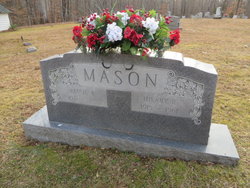
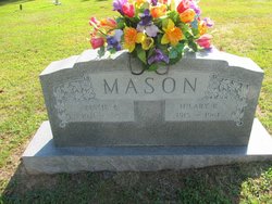
Bessie Bigger Mason
| Birth | : | 18 Jun 1921 |
| Death | : | 27 Dec 2014 Prince Edward County, Virginia, USA |
| Burial | : | St Leonard Churchyard, Farleigh Hungerford, Mendip District, England |
| Coordinate | : | 51.3155390, -2.2884820 |
| Description | : | Bessie Bigger Mason, age 93, of Keysville, VA, passed away on Saturday, December 27, 2014. She is survived by one son, Hilary Dale Mason and his wife, Linda of Drakes Branch, VA; a daughter, Janet Mason Harmon and her husband, Brent of Keysville, VA; five grandchildren, Matthew Mason of Burlington, N. C., Benjamin Mason of Corvallis, OR, Aimee Hudson and her husband, Sam, Hilary Harmon and Scott, Meri Harmon all of Keysville, VA; four great-grandchildren, Chris, Sarah, Bentley, and Aubrey. Bessie was preceded in death by her husband, Hilary R. Mason; and a grandson, Chris Johnson. A funeral service will be held at... Read More |
frequently asked questions (FAQ):
-
Where is Bessie Bigger Mason's memorial?
Bessie Bigger Mason's memorial is located at: St Leonard Churchyard, Farleigh Hungerford, Mendip District, England.
-
When did Bessie Bigger Mason death?
Bessie Bigger Mason death on 27 Dec 2014 in Prince Edward County, Virginia, USA
-
Where are the coordinates of the Bessie Bigger Mason's memorial?
Latitude: 51.3155390
Longitude: -2.2884820
Family Members:
Spouse
Flowers:


Nearby Cemetories:
1. St Leonard Churchyard
Farleigh Hungerford, Mendip District, England
Coordinate: 51.3155390, -2.2884820
2. Farleigh Hungerford Castle
Farleigh Hungerford, Mendip District, England
Coordinate: 51.3173500, -2.2869590
3. All Saints Churchyard
Tellisford, Mendip District, England
Coordinate: 51.2997270, -2.2877180
4. St. John the Baptist Churchyard
Hinton Charterhouse, Bath and North East Somerset Unitary Authority, England
Coordinate: 51.3233330, -2.3219440
5. Freshford Cemetery
Freshford, Bath and North East Somerset Unitary Authority, England
Coordinate: 51.3379620, -2.3082970
6. Saint Peters Churchyard
Freshford, Bath and North East Somerset Unitary Authority, England
Coordinate: 51.3400570, -2.3033340
7. Norton St. Philip Churchyard
Norton St Philip, Mendip District, England
Coordinate: 51.3001680, -2.3279700
8. Christ Church Churchyard
Rode, Mendip District, England
Coordinate: 51.2861620, -2.2790890
9. St. Lawrence Churchyard
Woolverton, Mendip District, England
Coordinate: 51.2851540, -2.3021790
10. St Lawrence Churchyard
Rode, Mendip District, England
Coordinate: 51.2792750, -2.2765370
11. Holy Trinity Churchyard
Bradford-on-Avon, Wiltshire Unitary Authority, England
Coordinate: 51.3465927, -2.2538147
12. Midford Burial Ground
Bath, Bath and North East Somerset Unitary Authority, England
Coordinate: 51.3394360, -2.3391424
13. Christ Church Churchyard
Bradford-on-Avon, Wiltshire Unitary Authority, England
Coordinate: 51.3507000, -2.2493360
14. St Mary's Churchyard
Laverton, Mendip District, England
Coordinate: 51.2757380, -2.3195910
15. Holt Cemetery
Bradford-on-Avon, Wiltshire Unitary Authority, England
Coordinate: 51.3468710, -2.2352160
16. Bradford on Avon Cemetery
Bradford-on-Avon, Wiltshire Unitary Authority, England
Coordinate: 51.3468700, -2.2336400
17. St. Michael's Churchyard
Monkton Combe, Bath and North East Somerset Unitary Authority, England
Coordinate: 51.3559540, -2.3285700
18. All Saints Churchyard
Lullington, Mendip District, England
Coordinate: 51.2661940, -2.3121800
19. St George Churchyard
Beckington, Mendip District, England
Coordinate: 51.2635260, -2.2856810
20. St Julian's Churchyard
Wellow, Bath and North East Somerset Unitary Authority, England
Coordinate: 51.3240160, -2.3717630
21. Beckington Baptist Chapel Burial Ground
Beckington, Mendip District, England
Coordinate: 51.2610760, -2.2897000
22. Union Chapel
Combe Down, Bath and North East Somerset Unitary Authority, England
Coordinate: 51.3594751, -2.3443662
23. St. James' Churchyard
South Stoke, Bath and North East Somerset Unitary Authority, England
Coordinate: 51.3497220, -2.3652780
24. Jewish Burial Ground
Combe Down, Bath and North East Somerset Unitary Authority, England
Coordinate: 51.3599170, -2.3534670