

Betty J. Byrns Wilder
| Birth | : | 18 Feb 1940 Lexington, Dawson County, Nebraska, USA |
| Death | : | 20 Dec 2016 Hays, Ellis County, Kansas, USA |
| Burial | : | St Peter's Churchyard, Carlton Colville, Waveney District, England |
| Coordinate | : | 52.4514530, 1.6929030 |
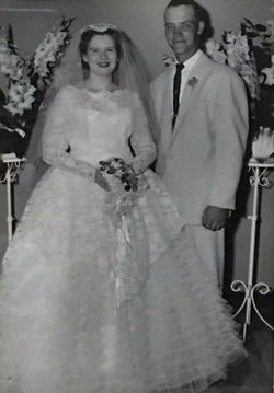
| Description | : | Betty J. Wilder, 76, Hays, died Tuesday, December 20, 2016 at her home. She was born February 18, 1940 in Lexington, Nebraska the daughter of James and Verna (Rasmussen) Byrns. She graduated from Lexington High School in 1958. On September 13, 1958 she married James E. "Jim" Wilder in Lexington. He preceded her in death on April 14, 2000. She was an oil company bookkeeper and also for Living Independently in Northwest Kansas or LINK, Inc. for many years. She volunteered her time at the Cancer Council of Ellis County and served on their Board of Directors for ten... Read More |
frequently asked questions (FAQ):
-
Where is Betty J. Byrns Wilder's memorial?
Betty J. Byrns Wilder's memorial is located at: St Peter's Churchyard, Carlton Colville, Waveney District, England.
-
When did Betty J. Byrns Wilder death?
Betty J. Byrns Wilder death on 20 Dec 2016 in Hays, Ellis County, Kansas, USA
-
Where are the coordinates of the Betty J. Byrns Wilder's memorial?
Latitude: 52.4514530
Longitude: 1.6929030
Family Members:
Parent

Spouse
Flowers:


Nearby Cemetories:
1. St Peter's Churchyard
Carlton Colville, Waveney District, England
Coordinate: 52.4514530, 1.6929030
2. St Peter's New Churchyard
Carlton Colville, Waveney District, England
Coordinate: 52.4528500, 1.6953250
3. Holy Trinity Churchyard
Gisleham, Waveney District, England
Coordinate: 52.4372320, 1.6975344
4. St. Michael's Churchyard
Rushmere, Waveney District, England
Coordinate: 52.4332200, 1.6688300
5. All Saints & St Margaret Churchyard
Pakefield, Waveney District, England
Coordinate: 52.4533520, 1.7344150
6. St. Andrew's Churchyard
Mutford, Waveney District, England
Coordinate: 52.4387060, 1.6566540
7. Saint John the Baptist Churchyard
Barnby, Waveney District, England
Coordinate: 52.4510410, 1.6494740
8. Kirkley Cemetery
Lowestoft, Waveney District, England
Coordinate: 52.4583260, 1.7353110
9. St. Peter and St. John Churchyard
Kirkley, Waveney District, England
Coordinate: 52.4628290, 1.7384010
10. St. Michael's Churchyard
Oulton, Waveney District, England
Coordinate: 52.4823570, 1.6952900
11. St Mary's Churchyard
Burgh St Peter, South Norfolk District, England
Coordinate: 52.4840860, 1.6710830
12. St Edmund Churchyard
Kessingland, Waveney District, England
Coordinate: 52.4158970, 1.7157750
13. St Mary Churchyard
Henstead, Waveney District, England
Coordinate: 52.4159800, 1.6577200
14. Lowestoft Cemetery
Lowestoft, Waveney District, England
Coordinate: 52.4814390, 1.7404560
15. St. Botolph Churchyard
North Cove, Waveney District, England
Coordinate: 52.4474411, 1.6227847
16. St Margaret Churchyard
Lowestoft, Waveney District, England
Coordinate: 52.4860970, 1.7402750
17. St. Michael's Churchyard
Benacre, Waveney District, England
Coordinate: 52.4003900, 1.6907680
18. Waveney Memorial Park and Crematorium
Ellough, Waveney District, England
Coordinate: 52.4314090, 1.6151750
19. Wrentham Municipal Cemetery
Wrentham, Waveney District, England
Coordinate: 52.4020520, 1.6676040
20. Lowestoft Naval Memorial
Lowestoft, Waveney District, England
Coordinate: 52.4883730, 1.7554520
21. RNPS Belle Vue Park Cemetery
Lowestoft, Waveney District, England
Coordinate: 52.4901740, 1.7559862
22. St. Peter's Churchyard
Gunton, Waveney District, England
Coordinate: 52.5003000, 1.7444000
23. All Saints Churchyard
Worlingham, Waveney District, England
Coordinate: 52.4517300, 1.5969000
24. Gunton Woodland Burial Park
Lowestoft, Waveney District, England
Coordinate: 52.5010260, 1.7461380