
| Birth | : | 12 Sep 1938 Marshalltown, Marshall County, Iowa, USA |
| Death | : | 14 Nov 2007 Marshalltown, Marshall County, Iowa, USA |
| Burial | : | Sydney North Head Quarantine Cemetery, Manly, Northern Beaches Council, Australia |
| Coordinate | : | -33.8177130, 151.2947000 |
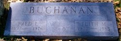
| Description | : | Betty Mae (Buchanan) Piper was born on Monday, September 12, 1938, in Marshalltown, Iowa. She was the daughter of Fred and Edith (Castell) Buchanan. She died on Wednesday, November 14, 2007, at her home in Marshalltown. Survivors include her long time companion, Dale, of Marshalltown; her daughters, Glenda Schmidt and Leslie Krough; her sons, Wayne Warnell, William Krough, and Kevin Krough; her grandchildren, great-grandchildren, and great-great-grandchildren; and her brothers Robert and Fred Buchanan. She was preceded in death by her parents; grandson, William Rhodes Jr.; her sister Mary Bogue; and her... Read More |
frequently asked questions (FAQ):
-
Where is Betty Mae Buchanan Piper's memorial?
Betty Mae Buchanan Piper's memorial is located at: Sydney North Head Quarantine Cemetery, Manly, Northern Beaches Council, Australia.
-
When did Betty Mae Buchanan Piper death?
Betty Mae Buchanan Piper death on 14 Nov 2007 in Marshalltown, Marshall County, Iowa, USA
-
Where are the coordinates of the Betty Mae Buchanan Piper's memorial?
Latitude: -33.8177130
Longitude: 151.2947000
Family Members:
Parent

Siblings

Flowers:


Nearby Cemetories:
1. Sydney North Head Quarantine Cemetery
Manly, Northern Beaches Council, Australia
Coordinate: -33.8177130, 151.2947000
2. Manly Cemetery
Manly, Northern Beaches Council, Australia
Coordinate: -33.7922700, 151.2715000
3. Rawson Park
Mosman, Mosman Municipality, Australia
Coordinate: -33.8350640, 151.2504980
4. Garden Island
Potts Point, City of Sydney, Australia
Coordinate: -33.8613635, 151.2280308
5. St. Thomas Rest Park
Crows Nest, North Sydney Council, Australia
Coordinate: -33.8244490, 151.2063050
6. Mary MacKillop Memorial Chapel
North Sydney, North Sydney Council, Australia
Coordinate: -33.8388250, 151.2049160
7. Royal Botanic Gardens
Sydney, City of Sydney, Australia
Coordinate: -33.8647440, 151.2170610
8. Saint Mary's Cathedral
Sydney, City of Sydney, Australia
Coordinate: -33.8708540, 151.2135820
9. Parish Church of Saint James
Sydney, City of Sydney, Australia
Coordinate: -33.8693760, 151.2111540
10. Gore Hill Cemetery
St Leonards, North Sydney Council, Australia
Coordinate: -33.8229500, 151.1887590
11. Old Sydney Burial Ground
Sydney, City of Sydney, Australia
Coordinate: -33.8731750, 151.2063850
12. Devonshire Street Cemetery (Defunct)
Sydney, City of Sydney, Australia
Coordinate: -33.8828080, 151.2066180
13. St Aidan's Anglican Church
Longueville, Lane Cove Municipality, Australia
Coordinate: -33.8281510, 151.1709560
14. Saint Jude's Cemetery
Randwick, Randwick City, Australia
Coordinate: -33.9115460, 151.2417130
15. Frenchs Forest Cemetery
Davidson, Northern Beaches Council, Australia
Coordinate: -33.7392360, 151.2020750
16. Randwick General Cemetery
South Coogee, Randwick City, Australia
Coordinate: -33.9295780, 151.2549810
17. Holy Trinity Church
Kingsford, Randwick City, Australia
Coordinate: -33.9267060, 151.2321180
18. Northern Suburbs Memorial Gardens and Crematorium
North Ryde, Ryde City, Australia
Coordinate: -33.7954460, 151.1511550
19. Camperdown Cemetery
Newtown, City of Sydney, Australia
Coordinate: -33.8942220, 151.1804900
20. Pioneers Memorial Park
Leichhardt, Inner West Council, Australia
Coordinate: -33.8780800, 151.1575000
21. Macquarie Park Cemetery and Crematorium
North Ryde, Ryde City, Australia
Coordinate: -33.7937180, 151.1420060
22. St Luke's Anglican Church
Enmore, Inner West Council, Australia
Coordinate: -33.8989218, 151.1700724
23. St. John's Anglican Church Cemetery
Gordon, Ku-ring-gai Council, Australia
Coordinate: -33.7571060, 151.1519580
24. Church of St. Francis and St. Alban
Gordon, Ku-ring-gai Council, Australia
Coordinate: -33.7563700, 151.1522220