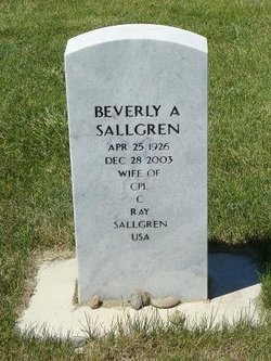
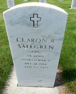
Beverly Ann Fuhrman Sallgren
| Birth | : | 25 Apr 1926 |
| Death | : | 28 Dec 2003 |
| Burial | : | St Nicholas Churchyard, Sturry, City of Canterbury, England |
| Coordinate | : | 51.2984830, 1.1201330 |
| Plot | : | Section A, Site R6-6 |
| Description | : | Beverly was born in Mansfield, South Dakota on April 25, 1926, the daughter of Ernest and Myrtle (Naessig) Fuhrman. She attended grade school and graduated from Warner High School in Mansfield. She worked for the state unemployment division in Aberdeen. Beverly married Ray Sallgren on September 3, 1948 in Warner, South Dakota. They then farmed at Warner until 1956 when they moved to Miles City where she went to work for the Forest Service. She later transferred to the BLM where she worked she worked as a range technician. She was the first female to become a range technician and... Read More |
frequently asked questions (FAQ):
-
Where is Beverly Ann Fuhrman Sallgren's memorial?
Beverly Ann Fuhrman Sallgren's memorial is located at: St Nicholas Churchyard, Sturry, City of Canterbury, England.
-
When did Beverly Ann Fuhrman Sallgren death?
Beverly Ann Fuhrman Sallgren death on 28 Dec 2003 in
-
Where are the coordinates of the Beverly Ann Fuhrman Sallgren's memorial?
Latitude: 51.2984830
Longitude: 1.1201330
Family Members:
Parent
Spouse
Siblings
Flowers:
Nearby Cemetories:
1. St Nicholas Churchyard
Sturry, City of Canterbury, England
Coordinate: 51.2984830, 1.1201330
2. St Mary the Virgin Churchyard
Fordwich, City of Canterbury, England
Coordinate: 51.2958300, 1.1270530
3. Sturry Cemetery
Sturry, City of Canterbury, England
Coordinate: 51.3058100, 1.1277700
4. All Saints Churchyard
Westbere, City of Canterbury, England
Coordinate: 51.3065380, 1.1437670
5. St Gregory Churchyard
Canterbury, City of Canterbury, England
Coordinate: 51.2816050, 1.0887840
6. St Martin Churchyard
Canterbury, City of Canterbury, England
Coordinate: 51.2780170, 1.0937160
7. St Gregory's Priory (defunct)
Canterbury, City of Canterbury, England
Coordinate: 51.2831127, 1.0855358
8. St. John the Baptist Hospital Chapelyard
Canterbury, City of Canterbury, England
Coordinate: 51.2832713, 1.0837677
9. St Mary Northgate Cemetery
Canterbury, City of Canterbury, England
Coordinate: 51.2811320, 1.0859300
10. St Augustine Abbey Ruins
Canterbury, City of Canterbury, England
Coordinate: 51.2781280, 1.0882060
11. St Paul Without the Walls
Canterbury, City of Canterbury, England
Coordinate: 51.2779380, 1.0853180
12. Canterbury Cathedral
Canterbury, City of Canterbury, England
Coordinate: 51.2796936, 1.0826840
13. St Mary Magdalene Church Demolished
Canterbury, City of Canterbury, England
Coordinate: 51.2784510, 1.0830170
14. St George's Church Demolished
Canterbury, City of Canterbury, England
Coordinate: 51.2773770, 1.0827380
15. All Saints Church Demolished
Canterbury, City of Canterbury, England
Coordinate: 51.2802800, 1.0783450
16. St Peter the Apostle Churchyard
Canterbury, City of Canterbury, England
Coordinate: 51.2807260, 1.0775370
17. St Mary Breadman Church Demolished
Canterbury, City of Canterbury, England
Coordinate: 51.2798870, 1.0784520
18. St Margaret's Churchyard
Canterbury, City of Canterbury, England
Coordinate: 51.2781780, 1.0795840
19. St Peters Methodist Church
Canterbury, City of Canterbury, England
Coordinate: 51.2801720, 1.0771480
20. St Mary Bredin Old Church (Defunct)
Canterbury, City of Canterbury, England
Coordinate: 51.2773455, 1.0803962
21. Holy Cross Church
Canterbury, City of Canterbury, England
Coordinate: 51.2811350, 1.0755710
22. Westgate Gardens
Canterbury, City of Canterbury, England
Coordinate: 51.2805250, 1.0745040
23. Canterbury Jewish Cemetery
Canterbury, City of Canterbury, England
Coordinate: 51.2846135, 1.0706660
24. St. Dunstan Churchyard
Canterbury, City of Canterbury, England
Coordinate: 51.2836820, 1.0707800


