
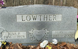
Buryel Annalea McHenry Lowther
| Birth | : | 6 Feb 1915 Gilmer County, West Virginia, USA |
| Death | : | 12 Oct 2002 West Virginia, USA |
| Burial | : | Hiney Hill Cemetery, Linn, Gilmer County, USA |
| Coordinate | : | 38.9676950, -80.7405600 |
| Description | : | Buryel A. Lowther Buryel Annalea Lowther, 87, of Linn, W.Va., died Oct. 12, 2002, at Sunbridge Care & Rehabilitation, Glenville, following an extended illness.. She was born Feb. 6, 1915, in Gilmer County, daughter of the late Christian L. and Mary Madge Messenger McHenry. Mrs. Lowther was a homemaker and member of the Ellis Grove United Methodist Church. Services will be 11 a.m. Tuesday at Ellyson Mortuary, Inc., Glenville. Burial will follow in the Hiney Hill Cemetery. Friends may call from 5-8 p.m. Monday at Ellyson Mortuary, Inc. The Parkersburg News and Sentinel 12 Oct 2002 |
frequently asked questions (FAQ):
-
Where is Buryel Annalea McHenry Lowther's memorial?
Buryel Annalea McHenry Lowther's memorial is located at: Hiney Hill Cemetery, Linn, Gilmer County, USA.
-
When did Buryel Annalea McHenry Lowther death?
Buryel Annalea McHenry Lowther death on 12 Oct 2002 in West Virginia, USA
-
Where are the coordinates of the Buryel Annalea McHenry Lowther's memorial?
Latitude: 38.9676950
Longitude: -80.7405600
Family Members:

Flowers:


Nearby Cemetories:
1. Hiney Hill Cemetery
Linn, Gilmer County, USA
Coordinate: 38.9676950, -80.7405600
2. Messenger Cemetery
Gilmer County, USA
Coordinate: 38.9714012, -80.7572021
3. Pickerel Cemetery
Baldwin, Gilmer County, USA
Coordinate: 38.9891200, -80.7289800
4. Conrad Cemetery
Sand Fork, Gilmer County, USA
Coordinate: 38.9364014, -80.7296982
5. Keith Cemetery
Gilmer County, USA
Coordinate: 38.9561005, -80.6986008
6. Snyder Cemetery Stewarts Creek
Glenville, Gilmer County, USA
Coordinate: 38.9577800, -80.7836100
7. McHenry Cemetery #1
Sand Fork, Gilmer County, USA
Coordinate: 38.9353310, -80.7162630
8. McHenry Cemetery
Gilmer County, USA
Coordinate: 38.9341870, -80.7130200
9. Dyer Cemetery
Gilmer County, USA
Coordinate: 38.9319000, -80.7110977
10. Varner Cemetery
Sand Fork, Gilmer County, USA
Coordinate: 38.9254709, -80.7212012
11. Rogers Cemetery
Gilmer County, USA
Coordinate: 38.9406013, -80.6936035
12. Schoonover-Dawson Cemetery
Donlan, Gilmer County, USA
Coordinate: 38.9461770, -80.6854790
13. Farnsworth Cemetery
Linn, Gilmer County, USA
Coordinate: 39.0177994, -80.7378006
14. Sand Fork Cemetery
Gilmer County, USA
Coordinate: 38.9158890, -80.7480520
15. Killingsworth Cemetery
Sand Fork, Gilmer County, USA
Coordinate: 38.9169640, -80.7249834
16. Rock Grove Cemetery
Latonia, Gilmer County, USA
Coordinate: 39.0125008, -80.7018967
17. Otterbein Cemetery
Glenville, Gilmer County, USA
Coordinate: 38.9298550, -80.7916820
18. Boilon Cemetery
Gilmer County, USA
Coordinate: 38.9519005, -80.6718979
19. Old Field Fork Cemetery
Lewis County, USA
Coordinate: 38.9827995, -80.6710968
20. Hays Cemetery
Truebada, Gilmer County, USA
Coordinate: 38.9294400, -80.8026800
21. Troy IOOF Community Cemetery
Troy, Gilmer County, USA
Coordinate: 39.0281170, -80.7679560
22. Leading Creek Baptist Church Cemetery
Alice, Gilmer County, USA
Coordinate: 38.9969000, -80.8183700
23. Blackburn Cemetery
Blackburn, Gilmer County, USA
Coordinate: 38.9235700, -80.6743200
24. Dusk Camp United Methodist Church Cemetery
Gilmer County, USA
Coordinate: 38.8961140, -80.7325440