
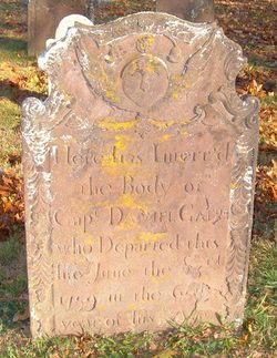
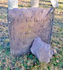
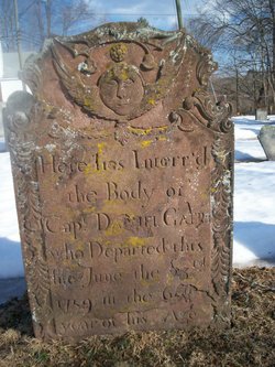
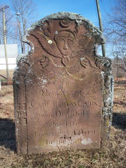
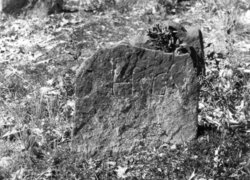
Capt Daniel Gates
| Birth | : | 26 May 1695 East Haddam, Middlesex County, Connecticut, USA |
| Death | : | 23 Jun 1759 |
| Burial | : | St Mary's Churchyard, Yate, South Gloucestershire Unitary Authority, England |
| Coordinate | : | 51.5431600, -2.4139020 |
| Description | : | in the 65th year of his age He was the son of Thomas Gates and Hannah Brainard. |
frequently asked questions (FAQ):
-
Where is Capt Daniel Gates's memorial?
Capt Daniel Gates's memorial is located at: St Mary's Churchyard, Yate, South Gloucestershire Unitary Authority, England.
-
When did Capt Daniel Gates death?
Capt Daniel Gates death on 23 Jun 1759 in
-
Where are the coordinates of the Capt Daniel Gates's memorial?
Latitude: 51.5431600
Longitude: -2.4139020
Family Members:
Parent
Spouse
Siblings


Children
Flowers:


Nearby Cemetories:
1. St Mary's Churchyard
Yate, South Gloucestershire Unitary Authority, England
Coordinate: 51.5431600, -2.4139020
2. St. John the Baptist Churchyard
Chipping Sodbury, South Gloucestershire Unitary Authority, England
Coordinate: 51.5389590, -2.3944150
3. St Peter's Churchyard & Wapley Burial Ground
Dodington, South Gloucestershire Unitary Authority, England
Coordinate: 51.5157603, -2.4138814
4. St Peter's Churchyard
Wapley, South Gloucestershire Unitary Authority, England
Coordinate: 51.5157000, -2.4137400
5. St James the Less Churchyard
Iron Acton, South Gloucestershire Unitary Authority, England
Coordinate: 51.5490390, -2.4619310
6. Mayshill Cemetery
South Gloucestershire Unitary Authority, England
Coordinate: 51.5562160, -2.4691663
7. Saint John the Baptist Churchyard
Old Sodbury, South Gloucestershire Unitary Authority, England
Coordinate: 51.5336010, -2.3561470
8. Church of the Holy Trinity
Rangeworthy, South Gloucestershire Unitary Authority, England
Coordinate: 51.5742000, -2.4536000
9. Westerleigh Crematorium
Westerleigh, South Gloucestershire Unitary Authority, England
Coordinate: 51.5044380, -2.4291520
10. St Peter's Churchyard
Frampton Cotterell, South Gloucestershire Unitary Authority, England
Coordinate: 51.5359115, -2.4801320
11. St Mary's Churchyard ( Private )
Dodington, South Gloucestershire Unitary Authority, England
Coordinate: 51.5172820, -2.3588590
12. St James the Elder Churchyard
Horton, South Gloucestershire Unitary Authority, England
Coordinate: 51.5637860, -2.3390110
13. Horton Church Cemetery
Horton, South Gloucestershire Unitary Authority, England
Coordinate: 51.5647100, -2.3388100
14. Holy Trinity Churchyard
Wickwar, South Gloucestershire Unitary Authority, England
Coordinate: 51.5985120, -2.4006930
15. Bristol Memorial Woodlands
Alveston, South Gloucestershire Unitary Authority, England
Coordinate: 51.5725340, -2.4983540
16. St Mary Magdelene Churchyard
Tormarton, South Gloucestershire Unitary Authority, England
Coordinate: 51.5082250, -2.3334930
17. St Mary Churchyard
Hawkesbury, South Gloucestershire Unitary Authority, England
Coordinate: 51.5807290, -2.3359910
18. Memorial Woodland Cemetery
Bristol Unitary Authority, England
Coordinate: 51.5754490, -2.5013060
19. St James Parish Churchyard
Tytherington, South Gloucestershire Unitary Authority, England
Coordinate: 51.5932110, -2.4799250
20. St. Michael the Archangel Churchyard
Winterbourne, South Gloucestershire Unitary Authority, England
Coordinate: 51.5269000, -2.5183600
21. St Peter's Churchyard
Dyrham, South Gloucestershire Unitary Authority, England
Coordinate: 51.4804500, -2.3735900
22. St Anne's Churchyard
Siston, South Gloucestershire Unitary Authority, England
Coordinate: 51.4752200, -2.4499900
23. St Andrew Churchyard
Cromhall, South Gloucestershire Unitary Authority, England
Coordinate: 51.6121930, -2.4456930
24. St James The Great Churchyard Cemetery
Abson, South Gloucestershire Unitary Authority, England
Coordinate: 51.4716858, -2.4257848