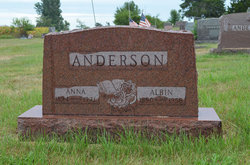
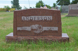
Carl Albin Anderson
| Birth | : | 17 Oct 1890 Odensvi, Västerviks kommun, Kalmar län, Sweden |
| Death | : | 25 Nov 1958 Stratford, Hamilton County, Iowa, USA |
| Burial | : | Blessed Virgin Mary Churchyard, Huish Episcopi, South Somerset District, England |
| Coordinate | : | 51.0362250, -2.8182410 |
| Description | : | Boone News Republican December 19, 1958 Albin C. Anderson Funeral services for Albin C. Anderson were held Saturday, Nov. 29, 1958, with a Prayer Service at the Hanson Funeral home at 1:30 p.m. for the family. Mrs. Arthur Larson and Mrs. Matt Hotchkiss sang a vocal duet accompanied by Mrs. Youngstrom. Services followed at 2 p.m. at the Mission Covenant Church with the Rev. Harry Dau in charge, assisted by Rev. Abraham of Pilot Mound, and Rev. Youngstrom of Dayton. Two vocal duets were sung by Mrs. Arthur Larson and Mrs. Matt Hotchkiss, accompanied by Mrs. Leroy Johnson. Pallbearers were Delmar Johnson, Gunnar Harmon,... Read More |
frequently asked questions (FAQ):
-
Where is Carl Albin Anderson's memorial?
Carl Albin Anderson's memorial is located at: Blessed Virgin Mary Churchyard, Huish Episcopi, South Somerset District, England.
-
When did Carl Albin Anderson death?
Carl Albin Anderson death on 25 Nov 1958 in Stratford, Hamilton County, Iowa, USA
-
Where are the coordinates of the Carl Albin Anderson's memorial?
Latitude: 51.0362250
Longitude: -2.8182410
Family Members:
Parent
Spouse
Siblings
Children
Flowers:
Nearby Cemetories:
1. Blessed Virgin Mary Churchyard
Huish Episcopi, South Somerset District, England
Coordinate: 51.0362250, -2.8182410
2. All Saints Churchyard
Langport, South Somerset District, England
Coordinate: 51.0369970, -2.8254530
3. Langport Cemetery
Langport, South Somerset District, England
Coordinate: 51.0426200, -2.8244600
4. St. Peter and St. Paul's Churchyard
Muchelney, South Somerset District, England
Coordinate: 51.0207389, -2.8154595
5. Low Ham Church in the Field
High Ham, South Somerset District, England
Coordinate: 51.0583449, -2.8155268
6. St John the Baptist Churchyard
Pitney, South Somerset District, England
Coordinate: 51.0532200, -2.7937320
7. St. Catherine's Churchyard
Drayton, South Somerset District, England
Coordinate: 51.0191860, -2.8494960
8. Curry Rivel Cemetery
Curry Rivel, South Somerset District, England
Coordinate: 51.0257667, -2.8676226
9. St. Andrew's Churchyard
Curry Rivel, South Somerset District, England
Coordinate: 51.0246570, -2.8687410
10. Saint Andrew's Churchyard
Aller, South Somerset District, England
Coordinate: 51.0554000, -2.8627000
11. Long Sutton Friends Burial Ground
Long Sutton, South Somerset District, England
Coordinate: 51.0302700, -2.7612300
12. High Ham Cemetery
High Ham, South Somerset District, England
Coordinate: 51.0739931, -2.8216351
13. Holy Trinity Churchyard
Long Sutton, South Somerset District, England
Coordinate: 51.0246110, -2.7577940
14. St. Andrew's Churchyard
High Ham, South Somerset District, England
Coordinate: 51.0760320, -2.8218400
15. Christ Church Cemetery
Long Load, South Somerset District, England
Coordinate: 51.0054700, -2.7639100
16. St. Martin's Churchyard
Kingsbury Episcopi, South Somerset District, England
Coordinate: 50.9863950, -2.8043130
17. St. Catherine's Churchyard
Fivehead, South Somerset District, England
Coordinate: 51.0083009, -2.9000973
18. St. James the Less Churchyard
Hambridge, South Somerset District, England
Coordinate: 50.9849380, -2.8669180
19. Othery Cemetery
Othery, Sedgemoor District, England
Coordinate: 51.0771222, -2.8906189
20. Ash Parish Cemetery
Ash, South Somerset District, England
Coordinate: 50.9833540, -2.7538380
21. Holy Trinity Churchyard
Ash, South Somerset District, England
Coordinate: 50.9834250, -2.7528400
22. St Michael Churchyard
Burrowbridge, Taunton Deane Borough, England
Coordinate: 51.0698090, -2.9174960
23. Saint Andrew Churchyard
Compton Dundon, South Somerset District, England
Coordinate: 51.0897330, -2.7442800
24. Stoke St Gregory
Stoke St Gregory, Taunton Deane Borough, England
Coordinate: 51.0398130, -2.9310570

