

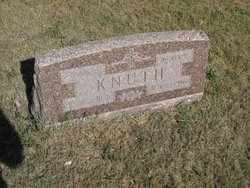
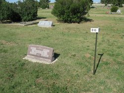
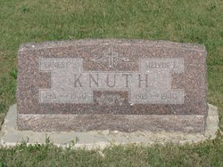
Carl August Knuth
| Birth | : | 8 Dec 1859 Stolp, Landkreis Havelland, Brandenburg, Germany |
| Death | : | 9 Jun 1936 Pierre, Hughes County, South Dakota, USA |
| Burial | : | Troqueer New Burial Ground, Scotland |
| Coordinate | : | 55.0399246, -3.6174200 |
| Description | : | In 1886 he came to America and located at Andover, South Dakota. In 1890 he was married to Johanna Wangerien who preceded him in death on March 1899. To this union there were five children born, two of whom died in infancy. Albert Knuth, the oldest boy, died at Codett, Canada in 1934. In December 1903 he was married to Murty Eggert of Andover, who survived him. This union was blessed with six children. |
frequently asked questions (FAQ):
-
Where is Carl August Knuth's memorial?
Carl August Knuth's memorial is located at: Troqueer New Burial Ground, Scotland.
-
When did Carl August Knuth death?
Carl August Knuth death on 9 Jun 1936 in Pierre, Hughes County, South Dakota, USA
-
Where are the coordinates of the Carl August Knuth's memorial?
Latitude: 55.0399246
Longitude: -3.6174200
Family Members:
Parent
Spouse
Siblings
Children
Flowers:


Nearby Cemetories:
1. Troqueer New Burial Ground
Scotland
Coordinate: 55.0399246, -3.6174200
2. Troqueer Parish Churchyard
Scotland
Coordinate: 55.0398254, -3.6175921
3. Caerlaverock Parish Churchyard
Scotland
Coordinate: 55.0072220, -3.5263890
4. Irongray Churchyard
Scotland
Coordinate: 55.0986790, -3.7017490
5. Irongray Kirkyard - Extention
Scotland
Coordinate: 55.1034857, -3.7632859
6. Southwick Cemetery
Scotland
Coordinate: 54.8953040, -3.7064180
7. Buittle Cemetery
Scotland
Coordinate: 54.9195320, -3.8605370
8. Colvend Parish Churchyard
Scotland
Coordinate: 54.8683920, -3.7742470
9. Keir Churchyard
Scotland
Coordinate: 55.2198710, -3.7941310
10. Balmaghie Parish Churchyard
Scotland
Coordinate: 54.9750000, -3.9969440
11. St Paul's Churchyard
Causewayhead, Allerdale Borough, England
Coordinate: 54.8671390, -3.3552630
12. Silloth Cemetery
Silloth, Allerdale Borough, England
Coordinate: 54.8666200, -3.3551000
13. Quaker Burial Ground
Beckfoot, Copeland Borough, England
Coordinate: 54.8330850, -3.4134130
14. St Michael Churchyard
Bowness-on-Solway, Allerdale Borough, England
Coordinate: 54.9523800, -3.2135380
15. Wesleyan Home Mission Chapel Cemetery
Bowness-on-Solway, Allerdale Borough, England
Coordinate: 54.9535940, -3.2120460
16. St John's Churchyard
Newton Arlosh, Allerdale Borough, England
Coordinate: 54.8853180, -3.2506160
17. Holme St Cuthbert Churchyard
Holme St Cuthbert, Allerdale Borough, England
Coordinate: 54.8108780, -3.3951990
18. Kirkcormack Cemetery
Scotland
Coordinate: 54.8946900, -4.0027600
19. Holme Cultram Abbey Churchyard
Abbeytown, Allerdale Borough, England
Coordinate: 54.8453090, -3.2832650
20. St Bride Churchyard
Kirkbride, Allerdale Borough, England
Coordinate: 54.9047600, -3.2026500
21. Quaker Burial Ground
Allonby, Allerdale Borough, England
Coordinate: 54.7790680, -3.4296924
22. Christ Churchyard
Allonby, Allerdale Borough, England
Coordinate: 54.7671880, -3.4309950
23. St. Mungo Churchyard
Bromfield, Allerdale Borough, England
Coordinate: 54.8109800, -3.2838200
24. St Matthew’s Churchyard
Westnewton, Allerdale Borough, England
Coordinate: 54.7848970, -3.3455930