
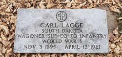
Carl Lagge
| Birth | : | 3 Nov 1895 Russia |
| Death | : | 12 Apr 1961 South Dakota, USA |
| Burial | : | Saint John the Evangelist Cemetery, Lambertville, Hunterdon County, USA |
| Coordinate | : | 40.3621100, -74.9412000 |
| Plot | : | Section 11 Lot 21 |
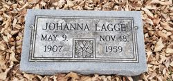
| Description | : | Married Johanna Weisser on 12-16-1934 in Delmont, Charles Mix, SD. |
frequently asked questions (FAQ):
-
Where is Carl Lagge's memorial?
Carl Lagge's memorial is located at: Saint John the Evangelist Cemetery, Lambertville, Hunterdon County, USA.
-
When did Carl Lagge death?
Carl Lagge death on 12 Apr 1961 in South Dakota, USA
-
Where are the coordinates of the Carl Lagge's memorial?
Latitude: 40.3621100
Longitude: -74.9412000
Family Members:
Spouse
Children

Flowers:


Nearby Cemetories:
1. Saint John the Evangelist Cemetery
Lambertville, Hunterdon County, USA
Coordinate: 40.3621100, -74.9412000
2. Mount Hope Cemetery
Lambertville, Hunterdon County, USA
Coordinate: 40.3630562, -74.9405594
3. First Presbyterian Church Cemetery
Lambertville, Hunterdon County, USA
Coordinate: 40.3667700, -74.9456300
4. Saint Martin of Tours Cemetery
New Hope, Bucks County, USA
Coordinate: 40.3614000, -74.9536000
5. New Hope Cemetery
New Hope, Bucks County, USA
Coordinate: 40.3552742, -74.9526825
6. Mount Moriah AME Church Cemetery
New Hope, Bucks County, USA
Coordinate: 40.3608900, -74.9619190
7. Holcombe Riverview Cemetery
Lambertville, Hunterdon County, USA
Coordinate: 40.3828011, -74.9535980
8. Saint Philips Episcopal Church Columbarium
New Hope, Bucks County, USA
Coordinate: 40.3783500, -74.9661800
9. Thompson Memorial Cemetery
New Hope, Bucks County, USA
Coordinate: 40.3353004, -74.9464035
10. Washington Crossing State Park
Washington Crossing, Bucks County, USA
Coordinate: 40.3311539, -74.9325943
11. Hunt Farm Cemetery
Hopewell, Mercer County, USA
Coordinate: 40.3375810, -74.9141400
12. Solebury Friends Graveyard
Solebury, Bucks County, USA
Coordinate: 40.3716393, -74.9867020
13. Stevenson Family Burying Ground
Mount Airy, Hunterdon County, USA
Coordinate: 40.3685188, -74.8912277
14. Phillips Family Burial Ground
Hopewell, Mercer County, USA
Coordinate: 40.3363330, -74.8979690
15. Saint Luke Lutheran Church Memorial Garden
Willingboro, Burlington County, USA
Coordinate: 40.3379800, -74.8936080
16. Second English Presbyterian Church Cemetery
Amwell, Hunterdon County, USA
Coordinate: 40.3984718, -74.9072189
17. Rocks Methodist Episcopal Cemetery
Mount Airy, Hunterdon County, USA
Coordinate: 40.3844986, -74.8835983
18. Winder Phillips Grave Yard
Mount Airy, Hunterdon County, USA
Coordinate: 40.3847222, -74.8833333
19. Trinity Episcopal Cemetery
Solebury, Bucks County, USA
Coordinate: 40.3820460, -75.0104710
20. Prallsville Cemetery
Hunterdon County, USA
Coordinate: 40.4090300, -74.9827760
21. Solebury Baptist Church Cemetery
Solebury, Bucks County, USA
Coordinate: 40.3507000, -75.0145000
22. Barber Burying Ground
Sandy Ridge, Hunterdon County, USA
Coordinate: 40.4190292, -74.9282608
23. Sandy Ridge Cemetery
Sandy Ridge, Hunterdon County, USA
Coordinate: 40.4232178, -74.9541168
24. Lewis Family Cemetery
Newtown, Allegheny County, USA
Coordinate: 40.3070080, -74.9820480