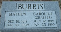
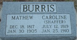
Caroline Shaffer Burris
| Birth | : | 12 Jul 1819 Hagerstown, Washington County, Maryland, USA |
| Death | : | 25 Jan 1910 Stafford, Stafford County, Kansas, USA |
| Burial | : | Oakwood Cemetery, Rochester, Olmsted County, USA |
| Coordinate | : | 44.0271988, -92.4558029 |
| Description | : | obituary from the Kansas Optimist published at Jamestown, Kansas, dated 3 Feb 1910: Caroline Shaffer was born July 12th, 1819, and died January 24th, 1910, age 90 years, 6 months and 13 days. She was united in marriage to Mathew Burris on December 5th, 1837, to which union were born ten children - seven boys and three girls - of which four boys and two girls are living. Her husband passed away January 31st, 1905. Mrs. Burris, with the family, moved to Kansas in 1877 and located six miles northwest of Jamestown where she resided until two years... Read More |
frequently asked questions (FAQ):
-
Where is Caroline Shaffer Burris's memorial?
Caroline Shaffer Burris's memorial is located at: Oakwood Cemetery, Rochester, Olmsted County, USA.
-
When did Caroline Shaffer Burris death?
Caroline Shaffer Burris death on 25 Jan 1910 in Stafford, Stafford County, Kansas, USA
-
Where are the coordinates of the Caroline Shaffer Burris's memorial?
Latitude: 44.0271988
Longitude: -92.4558029
Family Members:
Spouse
Children
Flowers:
Nearby Cemetories:
1. Oakwood Cemetery
Rochester, Olmsted County, USA
Coordinate: 44.0271988, -92.4558029
2. Calvary Cemetery
Rochester, Olmsted County, USA
Coordinate: 44.0285988, -92.4468994
3. Calvary Episcopal Church Columbarium
Rochester, Olmsted County, USA
Coordinate: 44.0220450, -92.4676640
4. Bethel Lutheran Church Columbarium
Rochester, Olmsted County, USA
Coordinate: 44.0147580, -92.4583110
5. First Presbyterian Church Columbarium
Rochester, Olmsted County, USA
Coordinate: 44.0201416, -92.4704132
6. Zumbro Lutheran Church Columbarium
Rochester, Olmsted County, USA
Coordinate: 44.0165200, -92.4664500
7. Rochester State Hospital Cemetery
Rochester, Olmsted County, USA
Coordinate: 44.0292700, -92.4377000
8. Rosemont Cemetery
Rochester, Olmsted County, USA
Coordinate: 44.0269880, -92.4369450
9. Our Saviors Lutheran Church Columbarium
Rochester, Olmsted County, USA
Coordinate: 44.0448920, -92.4330100
10. Grandview Memorial Gardens
Rochester, Olmsted County, USA
Coordinate: 44.0050011, -92.4368973
11. Congregational Church Columbarium
Rochester, Olmsted County, USA
Coordinate: 44.0122900, -92.4857200
12. First Unitarian Universalist Memorial Garden
Rochester, Olmsted County, USA
Coordinate: 44.0140700, -92.4876100
13. Saint Lukes Episcopal Church Columbarium
Rochester, Olmsted County, USA
Coordinate: 44.0453240, -92.4928450
14. Mount Olive Lutheran Church Columbarium
Rochester, Olmsted County, USA
Coordinate: 44.0540848, -92.4881973
15. Oakwood East Cemetery
Rochester, Olmsted County, USA
Coordinate: 44.0504990, -92.4079971
16. Mayowood Cemetery
Rochester, Olmsted County, USA
Coordinate: 43.9909500, -92.5218800
17. Boynton Cemetery
Ringe, Olmsted County, USA
Coordinate: 44.0916710, -92.4416733
18. Haverhill Cemetery
Olmsted County, USA
Coordinate: 44.0572014, -92.3692017
19. Chester Cemetery
Chester, Olmsted County, USA
Coordinate: 44.0002785, -92.3458328
20. Pleasant Prairie Cemetery
Rochester, Olmsted County, USA
Coordinate: 44.1006012, -92.5139008
21. Fitch Cemetery
Ringe, Olmsted County, USA
Coordinate: 44.1074982, -92.3886032
22. Mount Hope Cemetery
Rochester, Olmsted County, USA
Coordinate: 44.0703011, -92.5783005
23. Oakridge Farm Cemetery
Rochester, Olmsted County, USA
Coordinate: 43.9479480, -92.5435090
24. Saint Bridgets Catholic Church Cemetery
Simpson, Olmsted County, USA
Coordinate: 43.9230423, -92.4351883


