
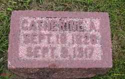
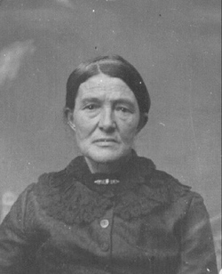
Catherine Ann Brandt Booton
| Birth | : | 18 Sep 1828 Juniata County, Pennsylvania, USA |
| Death | : | 9 Sep 1917 Audubon, Audubon County, Iowa, USA |
| Burial | : | Fairview Cemetery, La Junta, Otero County, USA |
| Coordinate | : | 37.9873000, -103.5607000 |
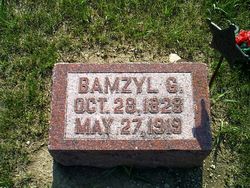
| Description | : | Catherine's first husband was Edwin E. Derby (1826-1850) Her parents were Martin Brandt and Catharine (Groninger) Brandt Doctors suggested Catherine take up smoking a pipe. Catherine watched over the homestead while Bamzyl went off to the Civil War. She cared for four children, and it was hard for her to remain calm and her Doctor suggested she take up smoking a pipe. To the end of her life in 1917, she smoked a little clay pipe. Children: Isadore Booton(1854-1856) |
frequently asked questions (FAQ):
-
Where is Catherine Ann Brandt Booton's memorial?
Catherine Ann Brandt Booton's memorial is located at: Fairview Cemetery, La Junta, Otero County, USA.
-
When did Catherine Ann Brandt Booton death?
Catherine Ann Brandt Booton death on 9 Sep 1917 in Audubon, Audubon County, Iowa, USA
-
Where are the coordinates of the Catherine Ann Brandt Booton's memorial?
Latitude: 37.9873000
Longitude: -103.5607000
Family Members:
Parent
Spouse
Children

Flowers:


Nearby Cemetories:
1. Fairview Cemetery
La Junta, Otero County, USA
Coordinate: 37.9873000, -103.5607000
2. Calvary Cemetery
La Junta, Otero County, USA
Coordinate: 37.9832000, -103.5622000
3. Saint Andrews Episcopal Church Columbarium
La Junta, Otero County, USA
Coordinate: 37.9809000, -103.5455000
4. Ormega Cemetery
La Junta, Otero County, USA
Coordinate: 37.9684000, -103.5770000
5. Saint Paul’s Lutheran Cemetery
Otero County, USA
Coordinate: 38.0342000, -103.4542000
6. Holbrook Cemetery
Otero County, USA
Coordinate: 38.0842018, -103.5432968
7. Bents Old Fort Cemetery
La Junta, Otero County, USA
Coordinate: 38.0416000, -103.4297000
8. Hillcrest Cemetery
Rocky Ford, Otero County, USA
Coordinate: 38.0388985, -103.7071991
9. Valley View Cemetery
Rocky Ford, Otero County, USA
Coordinate: 38.0388985, -103.7093964
10. East Holbrook Mennonite Cemetery
Cheraw, Otero County, USA
Coordinate: 38.1101837, -103.4729767
11. Higbee Cemetery
Higbee, Otero County, USA
Coordinate: 37.7630997, -103.4555969
12. Timpas Cemetery
Timpas, Otero County, USA
Coordinate: 37.8081000, -103.7681000
13. Lakeview Cemetery
Sugar City, Crowley County, USA
Coordinate: 38.2332993, -103.6725006
14. Martinez Cemetery
Otero County, USA
Coordinate: 37.7303009, -103.5002975
15. Manzanola Mountainview Cemetery
Manzanola, Otero County, USA
Coordinate: 38.0900002, -103.8764038
16. Las Animas Cemetery
Las Animas, Bent County, USA
Coordinate: 38.0424995, -103.2174988
17. Boggsville National Historic Site Grounds
Boggsville, Bent County, USA
Coordinate: 38.0425130, -103.2102730
18. Valley View Cemetery
Ordway, Crowley County, USA
Coordinate: 38.2546997, -103.7489014
19. Olney Springs Cemetery
Olney Springs, Crowley County, USA
Coordinate: 38.1472282, -103.9310684
20. Pruett Cemetery
Bent County, USA
Coordinate: 37.7172012, -103.2897034
21. Barnard Burial Site
Elder, Otero County, USA
Coordinate: 38.1235554, -103.9665095
22. Dolores Mission Cemetery
Kim, Las Animas County, USA
Coordinate: 37.6365200, -103.5854900
23. Fort Lyon National Cemetery
Fort Lyon, Bent County, USA
Coordinate: 38.0847015, -103.1288986
24. Arlington Cemetery
Arlington, Kiowa County, USA
Coordinate: 38.3232994, -103.3597031