
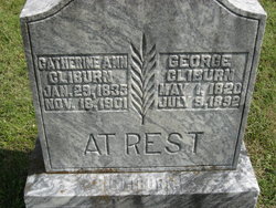

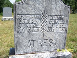
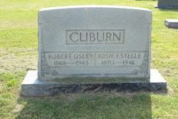
Catherine Ann Brown Cliburn
| Birth | : | 29 Jan 1835 Kentucky, USA |
| Death | : | 18 Nov 1901 Allen County, Kentucky, USA |
| Burial | : | Guttenberg Cemetery, Guttenberg, Clayton County, USA |
| Coordinate | : | 42.7691994, -91.1035995 |
frequently asked questions (FAQ):
-
Where is Catherine Ann Brown Cliburn's memorial?
Catherine Ann Brown Cliburn's memorial is located at: Guttenberg Cemetery, Guttenberg, Clayton County, USA.
-
When did Catherine Ann Brown Cliburn death?
Catherine Ann Brown Cliburn death on 18 Nov 1901 in Allen County, Kentucky, USA
-
Where are the coordinates of the Catherine Ann Brown Cliburn's memorial?
Latitude: 42.7691994
Longitude: -91.1035995
Family Members:
Spouse
Children

Flowers:


Nearby Cemetories:
1. Guttenberg Cemetery
Guttenberg, Clayton County, USA
Coordinate: 42.7691994, -91.1035995
2. Mount Olivet Cemetery
Guttenberg, Clayton County, USA
Coordinate: 42.7764840, -91.1083560
3. Saint Johns Cemetery
Jefferson Township, Clayton County, USA
Coordinate: 42.7497000, -91.1133000
4. Saint Marys Cemetery
Guttenberg, Clayton County, USA
Coordinate: 42.7691994, -91.1352997
5. Old Saint Marys Cemetery
Glen Haven, Grant County, USA
Coordinate: 42.8078100, -91.0675330
6. Bierer Cemetery
Millville, Clayton County, USA
Coordinate: 42.7230500, -91.0925166
7. Charlotte Cemetery
Glen Haven, Grant County, USA
Coordinate: 42.7933006, -91.0381012
8. Redman Cemetery
Millville, Clayton County, USA
Coordinate: 42.7166755, -91.0852901
9. Borcherding Cemetery
Jefferson Township, Clayton County, USA
Coordinate: 42.8182983, -91.1414032
10. Storck Cemetery
Guttenberg, Clayton County, USA
Coordinate: 42.7694335, -91.1834638
11. Friedlein Cemetery
Millville, Clayton County, USA
Coordinate: 42.7080994, -91.1108017
12. Lewis Cemetery
Osterdock, Clayton County, USA
Coordinate: 42.7416000, -91.1834000
13. Saint Michael Cemetery
Clayton County, USA
Coordinate: 42.8055992, -91.1802979
14. Duncan Cemetery
Glen Haven, Grant County, USA
Coordinate: 42.8325540, -91.0725940
15. Saint Paula Cemetery
Osterdock, Clayton County, USA
Coordinate: 42.7635994, -91.1992035
16. Gockel Cemetery
Glen Haven, Grant County, USA
Coordinate: 42.8224983, -91.0385971
17. Ramsey Cemetery
North Andover, Grant County, USA
Coordinate: 42.7817001, -90.9972000
18. Bethel Cemetery
Osterdock, Clayton County, USA
Coordinate: 42.7041702, -91.1688919
19. Pioneer Rock Cemetery
Ceres, Clayton County, USA
Coordinate: 42.8230591, -91.1863937
20. Goshen Cemetery
Millville, Clayton County, USA
Coordinate: 42.6905594, -91.0544434
21. Scott Cemetery
Glen Haven, Grant County, USA
Coordinate: 42.8368988, -91.0299988
22. Graham Cemetery
Millville, Clayton County, USA
Coordinate: 42.6833172, -91.1195685
23. Tangeman Family Cemetery
Garnavillo, Clayton County, USA
Coordinate: 42.8580000, -91.1420000
24. McClelland Cemetery
Garnavillo, Clayton County, USA
Coordinate: 42.8249879, -91.2084641