
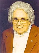


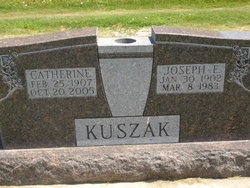
Catherine C. “Katie” Mroczek Kuszak
| Birth | : | 25 Feb 1907 Sherman County, Nebraska, USA |
| Death | : | 20 Oct 2005 Loup City, Sherman County, Nebraska, USA |
| Burial | : | Arvin Cemetery, Arvin, Kern County, USA |
| Coordinate | : | 35.2132300, -118.8952700 |
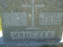
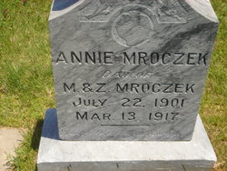
| Description | : | Daughter of Michael & Sophia (Barnas) Mroczek. Married to Joseph Kuszak on 10-12-1927 at Loup City, NE. |
frequently asked questions (FAQ):
-
Where is Catherine C. “Katie” Mroczek Kuszak's memorial?
Catherine C. “Katie” Mroczek Kuszak's memorial is located at: Arvin Cemetery, Arvin, Kern County, USA.
-
When did Catherine C. “Katie” Mroczek Kuszak death?
Catherine C. “Katie” Mroczek Kuszak death on 20 Oct 2005 in Loup City, Sherman County, Nebraska, USA
-
Where are the coordinates of the Catherine C. “Katie” Mroczek Kuszak's memorial?
Latitude: 35.2132300
Longitude: -118.8952700
Family Members:
Parent

Spouse
Siblings
Children
Flowers:


Nearby Cemetories:
1. Arvin Cemetery
Arvin, Kern County, USA
Coordinate: 35.2132300, -118.8952700
2. Greenlawn Southwest Mortuary and Cemetery
Bakersfield, Kern County, USA
Coordinate: 35.2948990, -119.0330810
3. Hillcrest Memorial Park
Bakersfield, Kern County, USA
Coordinate: 35.3814316, -118.9012527
4. Union Cemetery
Bakersfield, Kern County, USA
Coordinate: 35.3646500, -118.9948700
5. Home of Peace Jewish Cemetery
Bakersfield, Kern County, USA
Coordinate: 35.3631500, -118.9987400
6. Chinese Cemetery
Bakersfield, Kern County, USA
Coordinate: 35.3510550, -119.0273380
7. Bakersfield National Cemetery
Arvin, Kern County, USA
Coordinate: 35.2559600, -118.6693480
8. Saint Pauls Episcopal Church Columbarium
Bakersfield, Kern County, USA
Coordinate: 35.3746120, -119.0277940
9. Greenlawn Cemetery and Mortuary
Bakersfield, Kern County, USA
Coordinate: 35.4067001, -118.9856033
10. Fickert Family Cemetery
Bear Valley Springs, Kern County, USA
Coordinate: 35.1697260, -118.6443350
11. Kuntz Ranch Cemetery
Bakersfield, Kern County, USA
Coordinate: 35.4373560, -118.9390180
12. Tejon Indian Settlement Cemetery
Kern County, USA
Coordinate: 35.0422000, -118.6553900
13. Cesar E. Chavez National Monument
Keene, Kern County, USA
Coordinate: 35.2236000, -118.5592400
14. Tehachapi Cove Cemetery
Tehachapi, Kern County, USA
Coordinate: 35.1190000, -118.5724600
15. Brite Family Cemetery
Tehachapi, Kern County, USA
Coordinate: 35.1085350, -118.5473470
16. Rankin Cemetery
Walker Basin, Kern County, USA
Coordinate: 35.3844560, -118.5388890
17. Peter Lebeck Gravesite
Lebec, Kern County, USA
Coordinate: 34.8743040, -118.8926210
18. Long Tom Mine Cemetery
Woody, Kern County, USA
Coordinate: 35.5495600, -118.8308700
19. Fort Tejon Military Cemetery
Lebec, Kern County, USA
Coordinate: 34.8720500, -118.8971500
20. Old Tehachapi Cemetery
Tehachapi, Kern County, USA
Coordinate: 35.1400990, -118.4795570
21. Tehachapi Westside Cemetery
Tehachapi, Kern County, USA
Coordinate: 35.1387400, -118.4633600
22. Shafter Memorial Park
Shafter, Kern County, USA
Coordinate: 35.4728012, -119.2341995
23. Buhn Ranch Cemetery
Tehachapi, Kern County, USA
Coordinate: 35.1352210, -118.4319290
24. Paris-Loraine Cemetery
Loraine, Kern County, USA
Coordinate: 35.3059000, -118.4355000