
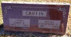
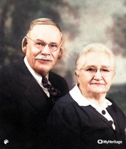
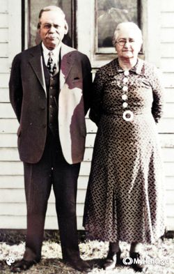
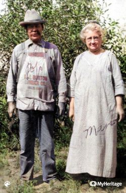
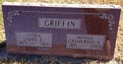
Catherine Elmina Sewart Griffin
| Birth | : | 7 May 1872 Bethany, Harrison County, Missouri, USA |
| Death | : | 12 Nov 1953 Miltonvale, Cloud County, Kansas, USA |
| Burial | : | Hollis Cemetery, Cloud County, USA |
| Coordinate | : | 39.6383018, -97.5361023 |
| Plot | : | Section B (N/E Quadrant) Row 4 |
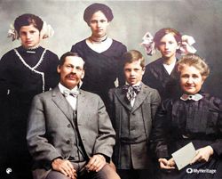
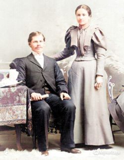
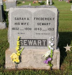
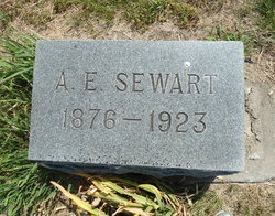
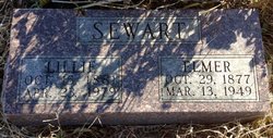
| Description | : | Catherine Elmina Sewart, born May 7, 1872, in Bethany, Missouri, was the first of four children born to Fredrick Ferdinand Sewart and Sarah Ann (Cochran) Sewart. Catherine's father was a farmer by trade. She spent the first seven years of her childhood in Bethany, Missouri until her family moved to Hollis, Kansas in March of 1879. Hollis was a small farming community at that time located in Lawrence Township, Cloud County. Catherine's younger siblings were, Ala Edward Sewart, Louis Elmer Sewart, and Maude Beatrice Sewart. After completed her education in the Hollis and Concordia schools, Catherine spent several... Read More |
frequently asked questions (FAQ):
-
Where is Catherine Elmina Sewart Griffin's memorial?
Catherine Elmina Sewart Griffin's memorial is located at: Hollis Cemetery, Cloud County, USA.
-
When did Catherine Elmina Sewart Griffin death?
Catherine Elmina Sewart Griffin death on 12 Nov 1953 in Miltonvale, Cloud County, Kansas, USA
-
Where are the coordinates of the Catherine Elmina Sewart Griffin's memorial?
Latitude: 39.6383018
Longitude: -97.5361023
Family Members:
Parent

Spouse
Siblings
Children

Flowers:


Nearby Cemetories:
1. Hollis Cemetery
Cloud County, USA
Coordinate: 39.6383018, -97.5361023
2. Zion Cemetery
Agenda, Republic County, USA
Coordinate: 39.6749992, -97.5939026
3. Beck Family Cemetery
Agenda, Republic County, USA
Coordinate: 39.6818000, -97.4863000
4. Union Cemetery
Wayne, Republic County, USA
Coordinate: 39.6977997, -97.5457993
5. Gotland Cemetery
Sibley Township, Cloud County, USA
Coordinate: 39.6091995, -97.6125031
6. Minersville Cemetery
Talmo, Republic County, USA
Coordinate: 39.6568330, -97.6229250
7. Walnut Grove Cemetery
Cloud County, USA
Coordinate: 39.5699997, -97.4993973
8. Rose Hill Cemetery
Wayne, Republic County, USA
Coordinate: 39.7111015, -97.5661011
9. Rice Cemetery
Rice, Cloud County, USA
Coordinate: 39.5614014, -97.5552979
10. Agenda Cemetery
Agenda, Republic County, USA
Coordinate: 39.6761017, -97.4336014
11. Murdock Family Cemetery
Cloud County, USA
Coordinate: 39.6386400, -97.6504800
12. Saron Lutheran Cemetery
Sibley Township, Cloud County, USA
Coordinate: 39.6385994, -97.6511002
13. Mount Hope Cemetery
Clyde, Cloud County, USA
Coordinate: 39.5969009, -97.4116974
14. Mount Calvary Cemetery
Clyde, Cloud County, USA
Coordinate: 39.5917015, -97.4143982
15. Frontier Cemetery
Belleville, Republic County, USA
Coordinate: 39.7400017, -97.5986023
16. Nelson Cemetery
Rice, Cloud County, USA
Coordinate: 39.5257988, -97.5410995
17. Green Mound Cemetery
Rice, Cloud County, USA
Coordinate: 39.5248450, -97.5081630
18. West Creek Cemetery
Belleville, Republic County, USA
Coordinate: 39.7041660, -97.6608930
19. Saint Concordia Cemetery
Concordia, Cloud County, USA
Coordinate: 39.5593800, -97.6503100
20. Sibley Cemetery
Sibley Township, Cloud County, USA
Coordinate: 39.6096992, -97.6908035
21. Nazareth Convent Cemetery
Concordia, Cloud County, USA
Coordinate: 39.5614000, -97.6612000
22. Pleasant View Cemetery
Ames, Cloud County, USA
Coordinate: 39.5346985, -97.4431000
23. Pleasant Hill Cemetery
Concordia, Cloud County, USA
Coordinate: 39.5583000, -97.6639023
24. Nelson Family Cemetery
Sibley Township, Cloud County, USA
Coordinate: 39.6366600, -97.7010600