| Birth | : | 21 Aug 1928 Danbury, Stokes County, North Carolina, USA |
| Death | : | 26 Jan 2016 |
| Burial | : | Pilot Mountain City Cemetery, Pilot Mountain, Surry County, USA |
| Coordinate | : | 36.3918343, -80.4809418 |
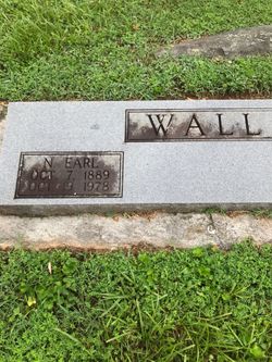
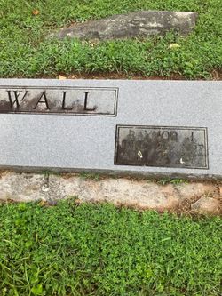
| Description | : | Mrs. Jean W. Baucom, 87, passed on Tuesday morning, January 26, 2016. Born on August 21, 1928 to the late Earl and Raynor Wall of Danbury, N.C., Jean (known to many as “Mama Jean”) embodied the graces of an exceptional woman. As one of four children, she forever sought great joy in the simple beauty of life. A loving wife, mother, grandmother, great-grandmother, sister, friend, Christian and citizen, she devoted herself to being present in every way she could. Whether baking and sharing her renowned pound cake, collecting heirlooms for the garden, keeping watch over her feathered friends, filling up... Read More |
frequently asked questions (FAQ):
-
Where is Catherine Jean “Mama Jean” Wall Baucom's memorial?
Catherine Jean “Mama Jean” Wall Baucom's memorial is located at: Pilot Mountain City Cemetery, Pilot Mountain, Surry County, USA.
-
When did Catherine Jean “Mama Jean” Wall Baucom death?
Catherine Jean “Mama Jean” Wall Baucom death on 26 Jan 2016 in
-
Where are the coordinates of the Catherine Jean “Mama Jean” Wall Baucom's memorial?
Latitude: 36.3918343
Longitude: -80.4809418
Family Members:
Parent
Spouse
Flowers:
Nearby Cemetories:
1. Pilot Mountain City Cemetery
Pilot Mountain, Surry County, USA
Coordinate: 36.3918343, -80.4809418
2. Green Family Cemetery
Pilot Mountain, Surry County, USA
Coordinate: 36.3956630, -80.4833990
3. Lovells Chapel Church Cemetery
Pilot Mountain, Surry County, USA
Coordinate: 36.3879160, -80.4652290
4. Tucker-Stone Cemetery
Surry County, USA
Coordinate: 36.3990000, -80.4954167
5. Bennett Cemetery
Pilot Mountain, Surry County, USA
Coordinate: 36.3988991, -80.4957962
6. Rescue Baptist Church Cemetery
Pilot Mountain, Surry County, USA
Coordinate: 36.3898080, -80.4613240
7. Beulahland Baptist Church Cemetery
Pilot Mountain, Surry County, USA
Coordinate: 36.4037330, -80.4954900
8. John Denny Cemetery
Pilot Mountain, Surry County, USA
Coordinate: 36.3755989, -80.4910965
9. John Wesley Hill Cemetery
Pilot Mountain, Surry County, USA
Coordinate: 36.4000282, -80.5012817
10. Stone Family Cemetery
Pilot Mountain, Surry County, USA
Coordinate: 36.3695070, -80.4689960
11. Friendly Chapel Church Cemetery
Pilot Mountain, Surry County, USA
Coordinate: 36.3635292, -80.4816132
12. Whitakers Chapel United Methodist Church Cemetery
Pilot Mountain, Surry County, USA
Coordinate: 36.3763008, -80.5105057
13. Sulphur Springs Baptist Church Cemetery
Pilot Mountain, Surry County, USA
Coordinate: 36.4074440, -80.5108871
14. Lawrence Cemetery
Pilot Mountain, Surry County, USA
Coordinate: 36.3716080, -80.4537230
15. Hills Presbyterian Church Cemetery
Hills Grove, Surry County, USA
Coordinate: 36.4234161, -80.4621658
16. Captain Bill Wilson Family Cemetery
Brims Grove, Stokes County, USA
Coordinate: 36.4168750, -80.4405590
17. Worth Cemetery
Ararat, Surry County, USA
Coordinate: 36.4180130, -80.5205710
18. Jessup Family Cemetery
Pilot Mountain, Surry County, USA
Coordinate: 36.4282990, -80.4563980
19. McDaniel Family Cemetery
Pilot Mountain, Surry County, USA
Coordinate: 36.4285800, -80.4560500
20. Carey Bird Denny Cemetery
Pilot Mountain, Surry County, USA
Coordinate: 36.3582000, -80.5177500
21. Hills Village Family Cemetery
Hills Grove, Surry County, USA
Coordinate: 36.4352200, -80.4594500
22. Ararat-Cedar Hill Primitive Baptist Church
Cedar Hill, Surry County, USA
Coordinate: 36.3671265, -80.5306778
23. Cox Cemetery
Pilot Mountain, Surry County, USA
Coordinate: 36.3743890, -80.5353890
24. Brim Family Cemetery
Stokes County, USA
Coordinate: 36.4026952, -80.4201749


