
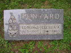
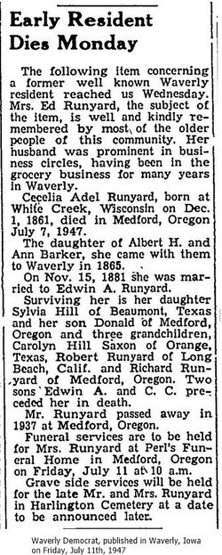
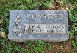
Cecelia Adel Barker Runyard
| Birth | : | 1 Dec 1861 White Creek, Adams County, Wisconsin, USA |
| Death | : | 7 Jul 1947 Medford, Jackson County, Oregon, USA |
| Burial | : | Oakwood Cemetery, Parsons, Labette County, USA |
| Coordinate | : | 37.3375500, -95.2402800 |
| Description | : | birth: Creek, Wi father: A. H. Barker mother: Ann Jacobus marriage: 29 November 1881 Bremer, Iowa spouse: Edwin J. Runyard parents: Austin Runyard, Jane Simmons Census 1880 Waverly, Bremer, Iowa Albert H Barker Self M 48 New York Ann Barker Wife F 41 Pennsylvania Celia A Barker Daughter F 18 Wisconsin Nettie Barker Daughter F 15 Wisconsin Albert H Barker Son M 10 Iowa James Jacobus Father-in-law M 79 New York Census 1900 Washington... Read More |
frequently asked questions (FAQ):
-
Where is Cecelia Adel Barker Runyard's memorial?
Cecelia Adel Barker Runyard's memorial is located at: Oakwood Cemetery, Parsons, Labette County, USA.
-
When did Cecelia Adel Barker Runyard death?
Cecelia Adel Barker Runyard death on 7 Jul 1947 in Medford, Jackson County, Oregon, USA
-
Where are the coordinates of the Cecelia Adel Barker Runyard's memorial?
Latitude: 37.3375500
Longitude: -95.2402800
Family Members:
Parent
Spouse
Siblings
Children
Flowers:


Nearby Cemetories:
1. Oakwood Cemetery
Parsons, Labette County, USA
Coordinate: 37.3375500, -95.2402800
2. Lucken Cemetery
Parsons, Labette County, USA
Coordinate: 37.3547870, -95.2854960
3. Pefley Cemetery
Parsons, Labette County, USA
Coordinate: 37.3564900, -95.2856000
4. Parsons State Hospital Cemetery
Parsons, Labette County, USA
Coordinate: 37.3571060, -95.2856310
5. Calvary Cemetery
Parsons, Labette County, USA
Coordinate: 37.3578100, -95.2855000
6. Memorial Lawn Cemetery
Parsons, Labette County, USA
Coordinate: 37.3013992, -95.2833023
7. Spring Hill Cemetery
Parsons, Labette County, USA
Coordinate: 37.2882000, -95.2497500
8. Mount Olivet Roman Catholic Cemetery
Parsons, Labette County, USA
Coordinate: 37.2998500, -95.2857500
9. Franklin Cemetery
Montana, Labette County, USA
Coordinate: 37.3182983, -95.1746979
10. East Bethany Cemetery
Neosho County, USA
Coordinate: 37.3983002, -95.2692032
11. West Bethany Cemetery
Neosho County, USA
Coordinate: 37.3983002, -95.2699966
12. Center Cemetery
Labette County, USA
Coordinate: 37.3396730, -95.1576630
13. Evergreen Cemetery
Neosho County, USA
Coordinate: 37.4008446, -95.2063217
14. Oak Grove Cemetery
Neosho County, USA
Coordinate: 37.3968925, -95.1700974
15. Fairview Cemetery
Parsons, Labette County, USA
Coordinate: 37.2963700, -95.1408800
16. Old Oak Grove Cemetery
Neosho County, USA
Coordinate: 37.4050751, -95.1635742
17. Ladore Cemetery
Ladore Township, Neosho County, USA
Coordinate: 37.4059000, -95.3169500
18. South Mound Cemetery
South Mound, Neosho County, USA
Coordinate: 37.4349800, -95.2245400
19. Brown Cemetery
Neosho County, USA
Coordinate: 37.4244003, -95.1725006
20. Labette Cemetery
Labette, Labette County, USA
Coordinate: 37.2447014, -95.1772003
21. Valley Cemetery
Galesburg, Neosho County, USA
Coordinate: 37.3986500, -95.3522400
22. Wilsonton Cemetery
Parsons, Labette County, USA
Coordinate: 37.2597700, -95.3397800
23. Richland Cemetery
Neosho County, USA
Coordinate: 37.4024162, -95.1253357
24. Montana Cemetery
Montana, Labette County, USA
Coordinate: 37.2661157, -95.1315282