

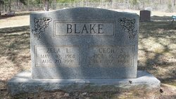
Cecil S. Blake
| Birth | : | 16 Oct 1909 Van Buren County, Arkansas, USA |
| Death | : | 17 Dec 1980 Cleveland, Conway County, Arkansas, USA |
| Burial | : | Turner Cemetery, Lockney, Gilmer County, USA |
| Coordinate | : | 38.8764000, -80.9555969 |
| Description | : | Cecil Blake married Zela Mills 3 September 1932 in Conway County, Arkansas (beta.familysearch.org). |
frequently asked questions (FAQ):
-
Where is Cecil S. Blake's memorial?
Cecil S. Blake's memorial is located at: Turner Cemetery, Lockney, Gilmer County, USA.
-
When did Cecil S. Blake death?
Cecil S. Blake death on 17 Dec 1980 in Cleveland, Conway County, Arkansas, USA
-
Where are the coordinates of the Cecil S. Blake's memorial?
Latitude: 38.8764000
Longitude: -80.9555969
Family Members:
Parent

Spouse
Siblings

Flowers:


Nearby Cemetories:
1. Turner Cemetery
Lockney, Gilmer County, USA
Coordinate: 38.8764000, -80.9555969
2. Johnny Godfrey Cemetery
Lockney, Gilmer County, USA
Coordinate: 38.8755150, -80.9503720
3. Riddle Cemetery
Lockney, Gilmer County, USA
Coordinate: 38.8854710, -80.9561810
4. Brown Cemetery
Gilmer County, USA
Coordinate: 38.8869070, -80.9272360
5. Riddle Cemetery
Hardman, Gilmer County, USA
Coordinate: 38.8961111, -80.9333333
6. Meadows Cemetery
Gilmer County, USA
Coordinate: 38.8506012, -80.9492035
7. Normantown Cemetery
Normantown, Gilmer County, USA
Coordinate: 38.8511040, -80.9403910
8. Snakeroot Cemetery
Gilmer County, USA
Coordinate: 38.8586006, -80.9910965
9. Cox Cemetery
Normantown, Gilmer County, USA
Coordinate: 38.8953300, -80.9170500
10. Maxwell-Collins Cemetery
Hardman, Gilmer County, USA
Coordinate: 38.9043220, -80.9195185
11. Mollohan Cemetery
Normantown, Gilmer County, USA
Coordinate: 38.8429600, -80.9262500
12. Collins Community Cemetery
Stumptown, Gilmer County, USA
Coordinate: 38.8459700, -80.9903630
13. Mount Pisgah Church Cemetery
Stumptown, Gilmer County, USA
Coordinate: 38.8469900, -80.9932700
14. Upper Steer Run Baptist Church Cemetery
Gilmer County, USA
Coordinate: 38.8429370, -80.9227830
15. Elihu-Stump Cemetery
Gilmer County, USA
Coordinate: 38.8403015, -80.9878006
16. Stump Cemetery
Stumptown, Gilmer County, USA
Coordinate: 38.8495000, -81.0030000
17. Michael Stump Cemetery-Steer Creek
Stumptown, Gilmer County, USA
Coordinate: 38.8273200, -80.9736800
18. Bethel-Bennett-Burns Cemetery
Grantsville, Calhoun County, USA
Coordinate: 38.9022000, -81.0153000
19. Shiloh Church Cemetery
Glenville, Gilmer County, USA
Coordinate: 38.9002200, -80.8920300
20. Chestnut Lick Community Church Cemetery
Gilmer County, USA
Coordinate: 38.8223950, -80.9426220
21. Job's Temple Cemetery
Glenville, Gilmer County, USA
Coordinate: 38.9322220, -80.9618810
22. Marks Cemetery
Cedarville, Gilmer County, USA
Coordinate: 38.8654400, -80.8835200
23. Beall Cemetery
Normantown, Gilmer County, USA
Coordinate: 38.8461306, -80.8910306
24. Tater Knob
Gilmer County, USA
Coordinate: 38.8988304, -80.8848038