
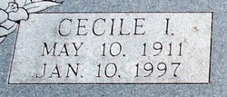
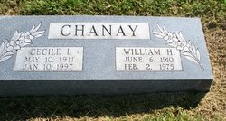
Cecile Irene Mitchell Chanay
| Birth | : | 10 May 1911 Douglas County, Kansas, USA |
| Death | : | 10 Jan 1997 Baldwin City, Douglas County, Kansas, USA |
| Burial | : | St. Michael's Churchyard, Creech St Michael, Taunton Deane Borough, England |
| Coordinate | : | 51.0223660, -3.0355780 |
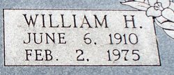
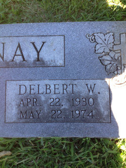
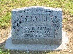
| Description | : | Parents per Mark Persons # 47050163 11/10/2018 Cecile M Chaney Wife United States Census, 1940 birth: 1912 Kansas residence: 1940 Palmyra Township, Douglas, Kansas spouse: William H Chaney children: Delbert W Chaney, Vera R Chaney Cecile I Chanay United States Public Records Index residence: 1 February 1994 Baldwin City, Kansas Cecile I Chanay United States Social Security Death Index birth: 10 May 1911 death: 10 January 1997 Douglas, Kansas Previous Residence Postal Code: 66006 (Baldwin City, KS) Age: 86 |
frequently asked questions (FAQ):
-
Where is Cecile Irene Mitchell Chanay's memorial?
Cecile Irene Mitchell Chanay's memorial is located at: St. Michael's Churchyard, Creech St Michael, Taunton Deane Borough, England.
-
When did Cecile Irene Mitchell Chanay death?
Cecile Irene Mitchell Chanay death on 10 Jan 1997 in Baldwin City, Douglas County, Kansas, USA
-
Where are the coordinates of the Cecile Irene Mitchell Chanay's memorial?
Latitude: 51.0223660
Longitude: -3.0355780
Family Members:
Parent
Spouse
Siblings
Children
Flowers:


Nearby Cemetories:
1. St. Michael's Churchyard
Creech St Michael, Taunton Deane Borough, England
Coordinate: 51.0223660, -3.0355780
2. St. George Churchyard
Ruishton, Taunton Deane Borough, England
Coordinate: 51.0206300, -3.0511400
3. Ruishton Church Cemetery
Ruishton, Taunton Deane Borough, England
Coordinate: 51.0204630, -3.0520420
4. Holy Cross at Thornfalcon
Taunton, Taunton Deane Borough, England
Coordinate: 51.0100970, -3.0229420
5. Stoke St. Mary Churchyard
Stoke St Mary, Taunton Deane Borough, England
Coordinate: 50.9955000, -3.0477000
6. St John the Baptist Churchyard
Durston, Taunton Deane Borough, England
Coordinate: 51.0478800, -3.0128490
7. St. Augustine Churchyard
West Monkton, Taunton Deane Borough, England
Coordinate: 51.0507000, -3.0528000
8. Buckland Priory
Durston, Taunton Deane Borough, England
Coordinate: 51.0476530, -2.9988180
9. St Mary Churchyard
Cheddon Fitzpaine, Taunton Deane Borough, England
Coordinate: 51.0426420, -3.0811930
10. Independent Baptist Churchyard
North Curry, Taunton Deane Borough, England
Coordinate: 51.0189703, -2.9779346
11. St Thomas Churchyard
Thurlbear, Taunton Deane Borough, England
Coordinate: 50.9847000, -3.0474100
12. Methodist Churchyard
North Curry, Taunton Deane Borough, England
Coordinate: 51.0213358, -2.9731175
13. Saint Andrew's Churchyard
West Hatch, Taunton Deane Borough, England
Coordinate: 50.9840980, -3.0195000
14. Taunton Priory of St Peter and St Paul
Taunton, Taunton Deane Borough, England
Coordinate: 51.0188270, -3.0988810
15. St. Peter & St. Paul's Churchyard
North Curry, Taunton Deane Borough, England
Coordinate: 51.0258710, -2.9716440
16. St. George's Roman Catholic Church
Taunton Deane Borough, England
Coordinate: 51.0130135, -3.0986681
17. United Reformed Church
Taunton, Taunton Deane Borough, England
Coordinate: 51.0130240, -3.0997408
18. St. Mary Magdalene Church
Taunton, Taunton Deane Borough, England
Coordinate: 51.0157120, -3.1006450
19. St James Churchyard
Taunton, Taunton Deane Borough, England
Coordinate: 51.0177320, -3.1012480
20. St Michael's Churchyard
Orchard Portman, Taunton Deane Borough, England
Coordinate: 50.9893670, -3.0788890
21. Saint Giles Church
Thurloxton, Sedgemoor District, England
Coordinate: 51.0684800, -3.0365270
22. Taunton Prison Cemetery
Taunton, Taunton Deane Borough, England
Coordinate: 51.0119040, -3.1074170
23. St. George Churchyard
Wilton, Taunton Deane Borough, England
Coordinate: 51.0090900, -3.1069000
24. St. John the Baptist Churchyard
Hatch Beauchamp, Taunton Deane Borough, England
Coordinate: 50.9852830, -2.9900880