
| Birth | : | 25 Mar 1962 Concordia, Cloud County, Kansas, USA |
| Death | : | 13 Jan 2012 Clay County, Kansas, USA |
| Burial | : | Mount Hope Cemetery, Clyde, Cloud County, USA |
| Coordinate | : | 39.5969009, -97.4116974 |
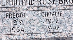
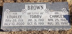
| Description | : | Charlene Reed died January 13, 2012 at Clay County Medical Center, Clay Center, Ks at the age of 49. She was born of March 25, 1962 in Concordia, Kansas the daughter of Charles and Lourilee (Likes) Brown. Charlene was raised in Clyde and Attended Clyde High School. She married Jon Reed on November 11, 2001, he survives of the home along with her special dogs, Missy and Bart. Survivors include: Husband: Jon Reed, clay Center, KS Daughter: Jackie Snavely-Barnes, and husband Jason of Clifton, Ks Daughter: Diane Snavely, Clifton, Ks Step daughters: Abbey Reed, Clay Center, Ks; Chelsey... Read More |
frequently asked questions (FAQ):
-
Where is Charlene Diane Brown Reed's memorial?
Charlene Diane Brown Reed's memorial is located at: Mount Hope Cemetery, Clyde, Cloud County, USA.
-
When did Charlene Diane Brown Reed death?
Charlene Diane Brown Reed death on 13 Jan 2012 in Clay County, Kansas, USA
-
Where are the coordinates of the Charlene Diane Brown Reed's memorial?
Latitude: 39.5969009
Longitude: -97.4116974
Family Members:
Parent
Siblings

Flowers:


Nearby Cemetories:
1. Mount Calvary Cemetery
Clyde, Cloud County, USA
Coordinate: 39.5917015, -97.4143982
2. Cedar Grove Cemetery
Clyde, Cloud County, USA
Coordinate: 39.5494003, -97.4056015
3. Pleasant View Cemetery
Ames, Cloud County, USA
Coordinate: 39.5346985, -97.4431000
4. Walnut Grove Cemetery
Cloud County, USA
Coordinate: 39.5699997, -97.4993973
5. Agenda Cemetery
Agenda, Republic County, USA
Coordinate: 39.6761017, -97.4336014
6. Saint Joseph Cemetery
Saint Joseph, Cloud County, USA
Coordinate: 39.5074941, -97.4022328
7. Beck Family Cemetery
Agenda, Republic County, USA
Coordinate: 39.6818000, -97.4863000
8. Green Mound Cemetery
Rice, Cloud County, USA
Coordinate: 39.5248450, -97.5081630
9. Hollis Cemetery
Cloud County, USA
Coordinate: 39.6383018, -97.5361023
10. Rice Cemetery
Rice, Cloud County, USA
Coordinate: 39.5614014, -97.5552979
11. Nelson Cemetery
Rice, Cloud County, USA
Coordinate: 39.5257988, -97.5410995
12. Riverdale Cemetery
Clay County, USA
Coordinate: 39.5106010, -97.2930984
13. Willoughby Cemetery
Agenda, Republic County, USA
Coordinate: 39.7402992, -97.4244003
14. Union Cemetery
Wayne, Republic County, USA
Coordinate: 39.6977997, -97.5457993
15. Saint Peters Cemetery
Aurora, Cloud County, USA
Coordinate: 39.4763985, -97.5180969
16. Princeville Cemetery
Aurora, Cloud County, USA
Coordinate: 39.4672012, -97.5010986
17. Iwacura Cemetery
Morganville, Clay County, USA
Coordinate: 39.4550000, -97.3510000
18. Gotland Cemetery
Sibley Township, Cloud County, USA
Coordinate: 39.6091995, -97.6125031
19. French Presbyterian Church Cemetery
Cloud County, USA
Coordinate: 39.4395200, -97.4148290
20. Sherman Cemetery
Morganville, Clay County, USA
Coordinate: 39.5316300, -97.2243700
21. Zion Cemetery
Agenda, Republic County, USA
Coordinate: 39.6749992, -97.5939026
22. Rose Hill Cemetery
Wayne, Republic County, USA
Coordinate: 39.7111015, -97.5661011
23. Minersville Cemetery
Talmo, Republic County, USA
Coordinate: 39.6568330, -97.6229250
24. Bloom Cemetery
Morganville, Clay County, USA
Coordinate: 39.4519005, -97.2778015