

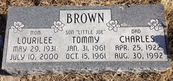
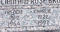
Charles Cole “Charlie” Brown
| Birth | : | 25 Apr 1922 Clyde, Cloud County, Kansas, USA |
| Death | : | 30 Aug 1992 Concordia, Cloud County, Kansas, USA |
| Burial | : | Mount Hope Cemetery, Clyde, Cloud County, USA |
| Coordinate | : | 39.5969009, -97.4116974 |
| Plot | : | Site 13-35 |
| Description | : | Salina Journal Monday, August 31, 1992 Charles "Charlie" Brown CLYDE — Charles "Charlie" Brown, 70, Clyde, died Sunday, Aug. 30, 1992, at St. Joseph Hospital, Concordia. Mr. Brown was born April 25, 1922, at Clyde and was a lifelong resident. He was employed as a welder by the former Combustion Engineering, Concordia, retiring in 1984. A son, Tommy Joe, preceded him in death. Survivors include his wife, Lourilee of Clyde; three sons, Steven and Jimmy, both of Salina, and Mark of Ames; a daughter, Charlene Reed of Clifton; two brothers, Homer and Gene, both of Clyde; a sister, Norma... Read More |
frequently asked questions (FAQ):
-
Where is Charles Cole “Charlie” Brown's memorial?
Charles Cole “Charlie” Brown's memorial is located at: Mount Hope Cemetery, Clyde, Cloud County, USA.
-
When did Charles Cole “Charlie” Brown death?
Charles Cole “Charlie” Brown death on 30 Aug 1992 in Concordia, Cloud County, Kansas, USA
-
Where are the coordinates of the Charles Cole “Charlie” Brown's memorial?
Latitude: 39.5969009
Longitude: -97.4116974
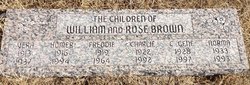
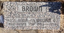
Family Members:
Parent

Spouse

Siblings

Children

Flowers:


Nearby Cemetories:
1. Mount Calvary Cemetery
Clyde, Cloud County, USA
Coordinate: 39.5917015, -97.4143982
2. Cedar Grove Cemetery
Clyde, Cloud County, USA
Coordinate: 39.5494003, -97.4056015
3. Pleasant View Cemetery
Ames, Cloud County, USA
Coordinate: 39.5346985, -97.4431000
4. Walnut Grove Cemetery
Cloud County, USA
Coordinate: 39.5699997, -97.4993973
5. Agenda Cemetery
Agenda, Republic County, USA
Coordinate: 39.6761017, -97.4336014
6. Saint Joseph Cemetery
Saint Joseph, Cloud County, USA
Coordinate: 39.5074941, -97.4022328
7. Beck Family Cemetery
Agenda, Republic County, USA
Coordinate: 39.6818000, -97.4863000
8. Green Mound Cemetery
Rice, Cloud County, USA
Coordinate: 39.5248450, -97.5081630
9. Hollis Cemetery
Cloud County, USA
Coordinate: 39.6383018, -97.5361023
10. Rice Cemetery
Rice, Cloud County, USA
Coordinate: 39.5614014, -97.5552979
11. Nelson Cemetery
Rice, Cloud County, USA
Coordinate: 39.5257988, -97.5410995
12. Riverdale Cemetery
Clay County, USA
Coordinate: 39.5106010, -97.2930984
13. Willoughby Cemetery
Agenda, Republic County, USA
Coordinate: 39.7402992, -97.4244003
14. Union Cemetery
Wayne, Republic County, USA
Coordinate: 39.6977997, -97.5457993
15. Saint Peters Cemetery
Aurora, Cloud County, USA
Coordinate: 39.4763985, -97.5180969
16. Princeville Cemetery
Aurora, Cloud County, USA
Coordinate: 39.4672012, -97.5010986
17. Iwacura Cemetery
Morganville, Clay County, USA
Coordinate: 39.4550000, -97.3510000
18. Gotland Cemetery
Sibley Township, Cloud County, USA
Coordinate: 39.6091995, -97.6125031
19. French Presbyterian Church Cemetery
Cloud County, USA
Coordinate: 39.4395200, -97.4148290
20. Sherman Cemetery
Morganville, Clay County, USA
Coordinate: 39.5316300, -97.2243700
21. Zion Cemetery
Agenda, Republic County, USA
Coordinate: 39.6749992, -97.5939026
22. Rose Hill Cemetery
Wayne, Republic County, USA
Coordinate: 39.7111015, -97.5661011
23. Minersville Cemetery
Talmo, Republic County, USA
Coordinate: 39.6568330, -97.6229250
24. Bloom Cemetery
Morganville, Clay County, USA
Coordinate: 39.4519005, -97.2778015