

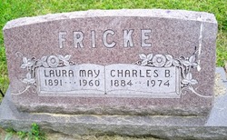
Charles B. Fricke
| Birth | : | 6 Jan 1884 Madison, Madison County, Nebraska, USA |
| Death | : | 7 Feb 1974 Nebraska, USA |
| Burial | : | Shepshed Cemetery, Shepshed, Charnwood Borough, England |
| Coordinate | : | 52.7640470, -1.2963120 |
| Description | : | Married to Laura May Smith on 6-10-1913 at Council Bluffs ,IA. --------------------------------- From the web site: http://www.usgennet.org/usa/ne/county/platte/whoplabios.html FRICKE, CHARLES B: Pharmacist; b Madison, Neb Jan 6, 1884; s of Herman Fricke-Johanna Ruegge; ed Madison HS; Omaha Coll of Pharm 1904; Philadelphia Coll of Pharm, PhG 1906; Phi Delta Chi; m Laura May Smith June 10, 1913 Council Bluffs Ia; d Jean, Doris, Mary, 1908-10 instr, Creighton U Omaha; 1910-20 owner Fricke Drug Co, Council Bluffs Ia; 1922- prop Fricke Drug Co, Columbus; 1934- pres Loup River Pub Power Dist, Consumers Pub Power Dist, Columbus; Neb Pharm Assn; BPOE; KP; Lions, past pres; Rep; hobby,... Read More |
frequently asked questions (FAQ):
-
Where is Charles B. Fricke's memorial?
Charles B. Fricke's memorial is located at: Shepshed Cemetery, Shepshed, Charnwood Borough, England.
-
When did Charles B. Fricke death?
Charles B. Fricke death on 7 Feb 1974 in Nebraska, USA
-
Where are the coordinates of the Charles B. Fricke's memorial?
Latitude: 52.7640470
Longitude: -1.2963120
Family Members:
Parent
Spouse
Siblings
Flowers:


Nearby Cemetories:
1. Shepshed Cemetery
Shepshed, Charnwood Borough, England
Coordinate: 52.7640470, -1.2963120
2. St. Botolph’s Churchyard
Shepshed, Charnwood Borough, England
Coordinate: 52.7726830, -1.2885670
3. St. James the Greater Oaks in Charnwood
Whitwick, North West Leicestershire District, England
Coordinate: 52.7425430, -1.3008590
4. Mount St Bernard Abbey
Whitwick, North West Leicestershire District, England
Coordinate: 52.7413880, -1.3234470
5. St John Churchyard
Belton, North West Leicestershire District, England
Coordinate: 52.7830810, -1.3374590
6. Grace-Dieu Priory
Thringstone, North West Leicestershire District, England
Coordinate: 52.7609720, -1.3566830
7. All Saints Churchyard
Thorpe Acre, Charnwood Borough, England
Coordinate: 52.7750466, -1.2361551
8. All Saints' Church Dishley
Hathern, Charnwood Borough, England
Coordinate: 52.7860705, -1.2412000
9. St Mary the Blessed Virgin Church
Osgathorpe, North West Leicestershire District, England
Coordinate: 52.7715890, -1.3623270
10. St. Peters & St. Paul Cemetery
Hathern, Charnwood Borough, England
Coordinate: 52.7970560, -1.2558040
11. All Saints Churchyard
Long Whatton, North West Leicestershire District, England
Coordinate: 52.8052840, -1.2859690
12. Greenhill Rise Cemetery
Hathern, Charnwood Borough, England
Coordinate: 52.7990180, -1.2576160
13. St John the Baptist Churchyard
Whitwick, North West Leicestershire District, England
Coordinate: 52.7416040, -1.3571200
14. St. Andrew's Churchyard
Thringstone, North West Leicestershire District, England
Coordinate: 52.7529090, -1.3692140
15. Broomleys Cemetery
Coalville, North West Leicestershire District, England
Coordinate: 52.7255540, -1.3402280
16. Whitwick Cemetery
Whitwick, North West Leicestershire District, England
Coordinate: 52.7395560, -1.3623360
17. Emmanuel Churchyard
Loughborough, Charnwood Borough, England
Coordinate: 52.7668830, -1.2108020
18. St George Churchyard
Swannington, North West Leicestershire District, England
Coordinate: 52.7530997, -1.3865110
19. St Michael & All Angels Churchyard
Long Whatton, North West Leicestershire District, England
Coordinate: 52.8164170, -1.3282730
20. Methodist Church Churchyard
Griffydam, North West Leicestershire District, England
Coordinate: 52.7629060, -1.3894370
21. All Saints with Holy Trinity Churchyard
Loughborough, Charnwood Borough, England
Coordinate: 52.7743880, -1.2035500
22. St Mary's Priory
Ulverscroft, Charnwood Borough, England
Coordinate: 52.7098890, -1.2598610
23. London Road Cemetery
Coalville, North West Leicestershire District, England
Coordinate: 52.7222620, -1.3647710
24. Christ Church
Coalville, North West Leicestershire District, England
Coordinate: 52.7229610, -1.3673630