
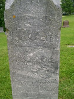
Charles Field
| Birth | : | 18 Sep 1814 Peterborough, Hillsborough County, New Hampshire, USA |
| Death | : | 6 Sep 1892 Lee County, Iowa, USA |
| Burial | : | Mount Tamalpais Cemetery, San Rafael, Marin County, USA |
| Coordinate | : | 37.9861984, -122.5544891 |
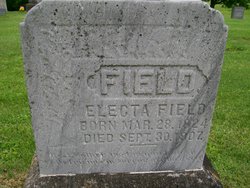
| Description | : | Son of William and Mary McAlister Field. Husband of Electa Brockway. Father to at least four children. FIELD, CHARLES, farmer, Sec. 5; P.O. Denmark; born in Peterboro, N.H., in 1817; he received an education at the common schools of the day, with two terms at the academy; at 21, he went to Lowell, Mass., and engaged in the manufacture of cotton for the print works; in 1837, he came to Lee Co., purchased a claim where he now resides, and owns 100 acres of land, valued at $55 per acre. In 1842, he married Miss Electa Brockway; her parents, Titus,... Read More |
frequently asked questions (FAQ):
-
Where is Charles Field's memorial?
Charles Field's memorial is located at: Mount Tamalpais Cemetery, San Rafael, Marin County, USA.
-
When did Charles Field death?
Charles Field death on 6 Sep 1892 in Lee County, Iowa, USA
-
Where are the coordinates of the Charles Field's memorial?
Latitude: 37.9861984
Longitude: -122.5544891
Family Members:
Spouse
Children

Flowers:


Nearby Cemetories:
1. Mount Tamalpais Cemetery
San Rafael, Marin County, USA
Coordinate: 37.9861984, -122.5544891
2. First Presbyterian Church Memorial Garden
San Anselmo, Marin County, USA
Coordinate: 37.9703310, -122.5667860
3. Montgomery Memorial Chapel Crypt
San Anselmo, Marin County, USA
Coordinate: 37.9687940, -122.5638630
4. Mount Olivet Catholic Cemetery
San Rafael, Marin County, USA
Coordinate: 38.0024986, -122.5397034
5. Mission San Rafael Arcangel Cemetery
San Rafael, Marin County, USA
Coordinate: 37.9744330, -122.5280570
6. Marin County Farm Cemetery
Marin County, USA
Coordinate: 38.0285500, -122.5652530
7. Saint Vincents Orphanage Cemetery
San Rafael, Marin County, USA
Coordinate: 38.0355800, -122.5334550
8. San Quentin Prison Cemetery
San Rafael, Marin County, USA
Coordinate: 37.9436480, -122.4883760
9. Druid Heights Burial Site
Mill Valley, Marin County, USA
Coordinate: 37.8892100, -122.5647100
10. Fernwood Cemetery
Mill Valley, Marin County, USA
Coordinate: 37.8767014, -122.5231018
11. St. Stephen's Episcopal Church Memorial Garden
Belvedere, Marin County, USA
Coordinate: 37.8767515, -122.4712901
12. Saint Mary Magdalene Catholic Church Cemetery
Bolinas, Marin County, USA
Coordinate: 37.9212570, -122.6938858
13. Bolinas Cemetery
Bolinas, Marin County, USA
Coordinate: 37.9212600, -122.6938900
14. Pioneer Memorial Cemetery
Novato, Marin County, USA
Coordinate: 38.1132532, -122.5902599
15. Valley Memorial Park
Novato, Marin County, USA
Coordinate: 38.1204300, -122.5436300
16. Taylor Cemetery
Lagunitas, Marin County, USA
Coordinate: 38.0272580, -122.7346590
17. Sailors Cemetery
Sausalito, Marin County, USA
Coordinate: 37.8442390, -122.4774770
18. Angel Island Cemetery (defunct)
Tiburon, Marin County, USA
Coordinate: 37.8621830, -122.4325920
19. Saint Pauls Cemetery (Defunct)
San Pablo, Contra Costa County, USA
Coordinate: 37.9563332, -122.3430099
20. Salesian Cemetery
Richmond, Contra Costa County, USA
Coordinate: 37.9532650, -122.3401230
21. Saint Joseph Catholic Cemetery
San Pablo, Contra Costa County, USA
Coordinate: 37.9612700, -122.3336600
22. Olema Cemetery
Olema, Marin County, USA
Coordinate: 38.0313988, -122.7789001
23. Rolling Hills Memorial Park
Richmond, Contra Costa County, USA
Coordinate: 37.9756012, -122.3146973
24. Presidio of San Francisco Pet Cemetery
San Francisco, San Francisco County, USA
Coordinate: 37.8025490, -122.4671960