
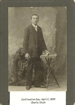
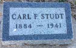
Charles Frederick “Carl” Studt
| Birth | : | 11 Feb 1884 Glasco, Cloud County, Kansas, USA |
| Death | : | 18 Dec 1941 Concordia, Cloud County, Kansas, USA |
| Burial | : | Glasco Cemetery, Glasco, Cloud County, USA |
| Coordinate | : | 39.3574000, -97.8265000 |
| Plot | : | 66W14 |
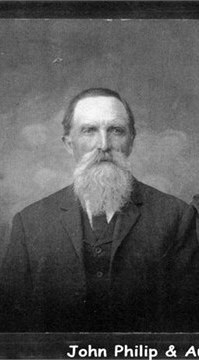
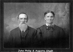
| Description | : | Glasco Sun, Dec. 25, 1941, page 3: Carl Frederick Studt, son of Philip and Augusta Studt, was born on a farm near Glasco, Kansas, February 11, 1884, and departed this life at Concordia, December 18, 1941, at the age of 57 years 10 months and 7 days. He was baptized and confirmed in the St. Paul's Lutheran Church of Glasco. Except for a period of three years spent in Idaho and near Concordia, his life was spent on the farm of his childhood. He was always ready to forget his own interests and lend a helping hand to others. ... Read More |
frequently asked questions (FAQ):
-
Where is Charles Frederick “Carl” Studt's memorial?
Charles Frederick “Carl” Studt's memorial is located at: Glasco Cemetery, Glasco, Cloud County, USA.
-
When did Charles Frederick “Carl” Studt death?
Charles Frederick “Carl” Studt death on 18 Dec 1941 in Concordia, Cloud County, Kansas, USA
-
Where are the coordinates of the Charles Frederick “Carl” Studt's memorial?
Latitude: 39.3574000
Longitude: -97.8265000
Family Members:
Parent
Siblings
Flowers:


Nearby Cemetories:
1. Glasco Cemetery
Glasco, Cloud County, USA
Coordinate: 39.3574000, -97.8265000
2. Saint Marys Catholic Cemetery
Glasco, Cloud County, USA
Coordinate: 39.3574000, -97.8245000
3. Simpson Cemetery
Simpson, Mitchell County, USA
Coordinate: 39.3633003, -97.9471970
4. Bethel Cemetery
Meredith Township, Cloud County, USA
Coordinate: 39.3506000, -97.7029000
5. Delphos Cemetery
Delphos, Ottawa County, USA
Coordinate: 39.2778015, -97.7416992
6. Saint Paul Cemetery
Delphos, Ottawa County, USA
Coordinate: 39.2677994, -97.7518997
7. Asherville Cemetery
Asherville, Mitchell County, USA
Coordinate: 39.4205000, -97.9672900
8. Morrison Cemetery
Center Township, Cloud County, USA
Coordinate: 39.4817009, -97.7975006
9. Summit Cemetery
Jamestown, Cloud County, USA
Coordinate: 39.4813200, -97.8628800
10. Green Mound Cemetery
Asherville, Mitchell County, USA
Coordinate: 39.3203011, -97.9858017
11. Coursen Grove Cemetery
Simpson, Mitchell County, USA
Coordinate: 39.3060989, -97.9792023
12. Hall Cemetery
Cloud County, USA
Coordinate: 39.4455986, -97.7033005
13. Saint Peters Cemetery
Miltonvale, Cloud County, USA
Coordinate: 39.3652350, -97.6483570
14. Bell-Bogardus Cemetery
Asherville, Mitchell County, USA
Coordinate: 39.4242410, -97.9919970
15. Bohemian National Cemetery
Ada, Ottawa County, USA
Coordinate: 39.2193870, -97.9054030
16. Wilcox Cemetery
Cloud County, USA
Coordinate: 39.4925003, -97.7313995
17. West Asher Cemetery
Scottsville, Mitchell County, USA
Coordinate: 39.4815000, -97.9661600
18. Baldwin Cemetery
Ottawa County, USA
Coordinate: 39.2061005, -97.9111023
19. Kindel Cemetery
Center Township, Cloud County, USA
Coordinate: 39.4519005, -97.6464005
20. Smith Cemetery
Asherville, Mitchell County, USA
Coordinate: 39.4516690, -98.0098850
21. McBride Cemetery
Beloit, Mitchell County, USA
Coordinate: 39.4808006, -97.9907990
22. Enterprise Cemetery
Cloud County, USA
Coordinate: 39.4230995, -97.6106033
23. Shiloh Cemetery
Beloit, Mitchell County, USA
Coordinate: 39.3574982, -98.0594025
24. Summit Cemetery #3
Macyville, Cloud County, USA
Coordinate: 39.5258330, -97.9194440