
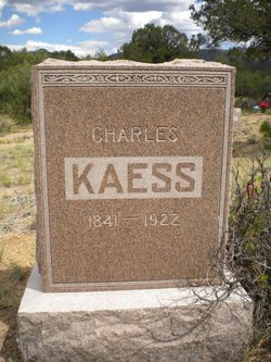
Charles Kaess
| Birth | : | 12 Jul 1841 Germany |
| Death | : | 2 Jan 1922 Chaffee County, Colorado, USA |
| Burial | : | Lake Of The Woods Cemetery, Kenora, Kenora District, Canada |
| Coordinate | : | 49.7764700, -94.4798500 |
| Description | : | The aged father of W. E. Kaess, of Adobe Park, passed away on last Monday morning, Jan. 2, at the ranch home, where he has resided for a long time. Mr. Kaess has been confined to his bed since June 23, when he fell, fracturing his hip. He was in the hospital for several weeks, but later returned to the ranch, where he passed away, never having been able to help himself at all. Charles Kaess was born near Stuttgart, Wuntemberg, Germany, July 12, 1841. He came to America In the early 60's, settling in Chicago. He later joined a... Read More |
frequently asked questions (FAQ):
-
Where is Charles Kaess's memorial?
Charles Kaess's memorial is located at: Lake Of The Woods Cemetery, Kenora, Kenora District, Canada.
-
When did Charles Kaess death?
Charles Kaess death on 2 Jan 1922 in Chaffee County, Colorado, USA
-
Where are the coordinates of the Charles Kaess's memorial?
Latitude: 49.7764700
Longitude: -94.4798500
Family Members:
Spouse
Children
Flowers:


Nearby Cemetories:
1. Lake Of The Woods Cemetery
Kenora, Kenora District, Canada
Coordinate: 49.7764700, -94.4798500
2. Pineridge Cemetery
Sioux Narrows, Kenora District, Canada
Coordinate: 49.3975171, -94.0623584
3. South East Whiteshell Cemetery
Falcon Lake, Eastern Manitoba Census Division, Canada
Coordinate: 49.7142730, -95.2546700
4. Fort Saint Charles Cemetery
Fort Saint Charles, Lake of the Woods County, USA
Coordinate: 49.3628400, -94.9807120
5. Good Shepherd Cemetery
Angle Inlet, Lake of the Woods County, USA
Coordinate: 49.3511110, -95.0822500
6. McIntosh First Nation Residential School Cemetery
McIntosh, Kenora District, Canada
Coordinate: 49.9794440, -93.6108330
7. McIntosh Cemetery
McIntosh, Kenora District, Canada
Coordinate: 49.9813175, -93.5870514
8. Vermilion Bay Catholic Cemetery
Vermilion Bay, Kenora District, Canada
Coordinate: 49.8782390, -93.4265730
9. Quibell Cemetery
Quibell, Kenora District, Canada
Coordinate: 49.9594491, -93.4252027
10. Norman Cottam Memorial Gardens
Nestor Falls, Kenora District, Canada
Coordinate: 49.1343810, -93.9210630
11. East Braintree Cemetery
East Braintree, Eastern Manitoba Census Division, Canada
Coordinate: 49.5985150, -95.6123610
12. Eagle River Cemetery
Eagle River, Kenora District, Canada
Coordinate: 49.7920670, -93.2036170
13. Saint Marys Riverside Cemetery
Prawda, Eastern Manitoba Census Division, Canada
Coordinate: 49.6903670, -95.7950330
14. Birch River Community Cemetery
Prawda, Eastern Manitoba Census Division, Canada
Coordinate: 49.7493580, -95.8491470
15. Minnitaki Cemetery
Minnitaki, Kenora District, Canada
Coordinate: 49.8157393, -93.0846587
16. Twin Rivers Mennonite Church Cemetery
Elma, Eastern Manitoba Census Division, Canada
Coordinate: 49.7973690, -95.8932610
17. Holy Cross Ukrainian Catholic Cemetery
Elma, Eastern Manitoba Census Division, Canada
Coordinate: 49.8742620, -95.9009350
18. Ukrainian Catholic Cemetery Ascension of Our Lord
Hadashville, Eastern Manitoba Census Division, Canada
Coordinate: 49.6945830, -95.9064670
19. St. Anthony of Padua Roman Catholic Cemetery
Elma, Eastern Manitoba Census Division, Canada
Coordinate: 49.8731000, -95.9073670
20. Saint John the Baptist Roman Catholic Cemetery
Hadashville, Eastern Manitoba Census Division, Canada
Coordinate: 49.6753170, -95.9071500
21. Prosper Township Cemetery
Birch Beach, Lake of the Woods County, USA
Coordinate: 48.8863450, -94.9375190
22. Hillside Cemetery
Lake of the Woods County, USA
Coordinate: 48.8436012, -94.8822021
23. Middlebro Community Cemetery
Middlebro, Eastern Manitoba Census Division, Canada
Coordinate: 49.0312000, -95.4318000
24. Stony Hill Cemetery
Stony Hill, Eastern Manitoba Census Division, Canada
Coordinate: 49.8688830, -95.9753670